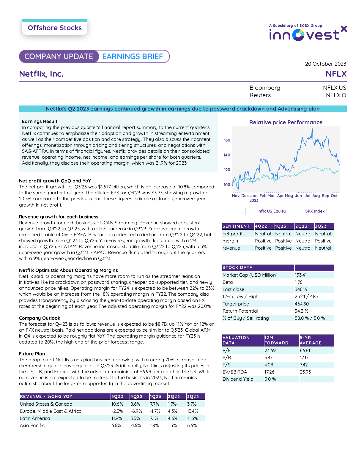
International cooperation in the peaceful uses of outer space: activities of Member States PDF Free Download
1 / 47/47
100%

United Nations
A
/AC.105/788
General Assembly
Distr.: General
2 December 2002
Original: Arabic/English/French/
Russian
V.02-60135 (E) 150103 160103
*0260135*
Committee on the Peaceful
Uses of Outer Space
International cooperation in the peaceful uses of outer
space: activities of Member States
Note by the Secretariat
Contents
Page
I. Introduction
..................................................................
2
II. Replies received from Member States
.............................................
2
Algeria
......................................................................
2
Azerbaijan
....................................................................
3
Finland
......................................................................
4
France
.......................................................................
8
Iran (Islamic Republic of)
.......................................................
14
Japan
........................................................................
20
Senegal
......................................................................
26
Slovakia
.....................................................................
26
Slovenia
.....................................................................
33
Syrian Arab Republic
...........................................................
34
Thailand
.....................................................................
36
Turkey
.......................................................................
36
Ukraine
......................................................................
40
United Kingdom of Great Britain and Northern Ireland
...............................
45

A/AC.105/788
2
I. Introduction
In the report on its thirty-ninth session, the Scientific and Technical
Subcommittee of the Committee on the Peaceful Uses of Outer Space agreed that
the Secretariat should continue to invite Member States to submit annual reports on
their space activities (A/AC.105/786, para. 15). In a note verbale dated 8 August
2002, the Secretary-General invited Governments to submit the reports by
15 November 2002. The present note was prepared by the Secretariat on the basis of
reports received from Member States in response to that invitation.
II. Replies from Member States
Algeria
[Original: French]
1.
The most prominent feature of Algeria’s space activity in 2002 is the
launching of the first Algerian microsatellite (ALSAT), scheduled for 28 November
2002. The project, carried out in collaboration with the Surrey Space Centre (United
Kingdom of Great Britain and Northern Ireland), is exclusively concerned with the
management and prevention of major risks.
2. The project, which forms part of an enlarged microsatellite constellation
involving China, Nigeria, Thailand, Turkey, the United Kingdom and Viet Nam, will
undoubtedly make it possible:
(a) To reduce the vulnerability of persons and property;
(b) To assess damage and facilitate the organization of disaster relief.
3. Recourse to space technologies has been adopted as a major strategic approach
to national socio-economic development. In that context, the political authorities
have included in the government programme for economic recovery a new ALSAT 2
high-resolution Earth observation microsatellite project.
4. The project forms part of a programme designed:
(a) To acquire capacities to gain access to space technologies through
international cooperation;
(b) To assimilate emerging applications;
(c) To provide the national user community with the resources for utilizing
data gathered by the satellite;
(d) To evolve space technologies to promote sustainable development and
environmental protection;
(e) To promote training and skills development in the field of space
technology applications.
5. Currently, space technology activities continue to be largely directed by the
National Centre for Space Technology, until such time as the new Algerian space
agency becomes operational.
A/AC.105/788
3
6. Initiatives to promote space technology activities have included the following
scientific events:
(a) The convening, by the Standing Committee on Space Technology of the
National Council of Geographical Information, of the Second National Colloquy on
Space Technology in Algiers on 24 and 25 June 2002;
(b) The convening, by the National Centre for Space Technology, of an open
day on space technology and its applications on 29 July 2002.
7. Mention should also be made of Algeria’s participation in a symposium
entitled “Space Technology Provides Solutions for Sustainable Development”, held
under the auspices of the United Nations, South Africa and the European Space
Agency (ESA), in Stellenbosch, South Africa, from 21 to 23 August 2002.
8. Lastly, in the context of its activities, the National Council of Geographical
Information has established a working group to assess the legal aspects of space
activities in Algeria. The work of this group, which was begun following Algeria’s
participation in the regional workshop on legal issues organized by the Regional
Centre for Remote Sensing of the North African States on 26 and 27 September
2002, is the result of a desire, first, to ensure that Algeria’s emerging space activities
are backed up by coherent legislation and, second, to provide an assessment of the
relevant international legal framework, particularly as elaborated by the United
Nations.
Azerbaijan
[Original: English]
1.
The use of the space information to provide the solutions necessary for
improving Azerbaijan’s economy is considered to be the priority for activities of the
Azerbaijan National Aerospace Agency (ANASA). Space images covering the
whole territory of Azerbaijan over recent years and data collected during previous
years are used for this purpose.
2.
In the former Union of Soviet Socialist Republics, ANASA had an opportunity
to carry out full-scale aerial photography of nearly the whole territory of Azerbaijan
using an MSF-6 camera on board an AN-30 laboratory plane. For this reason, the
data archive of Azerbaijan contains information dating back many years.
3.
Taking into account an intensive development of production and investigation
into new carbon sources, a project carried out by ANASA in which remote sensing
data and geological-geophysical research into the oil reserves of the Shemakha-
Gobustan area were used should be highlighted. The analysis of the results allows
the development of maps of tectonic intensity at different depth levels and,
indirectly, the prediction of oilfields and gas fields.
4.
Aerospace information is the only possible source of information for the study
of disaster processes such as landslides and land flows. These processes are very
important in the mountain areas of Azerbaijan, which account for up to 50 per cent
of the country. ANASA developed a method for the registration of such processes,
and on this basis maps of landslides, land flows and other disasters have been
created.
A/AC.105/788
4
5.
Disasters caused by seismic activity occur in Azerbaijan, where experts have
shown that earthquakes with a force of up to 7 or 8 on the Richter scale are possible.
The last strong earthquake, with a force of 6.5 on the Richter scale, was observed on
25 November 2001 several tens of kilometres from the capital of Azerbaijan. For
this reason, ANASA has developed and prepared for production a three-dimensional
seismometer with wide frequency (2x10⁻⁴-40 Hz) and dynamic (110-120 Db) range
that allows the user to register very weak seismic signals (10-2 µm) in analogue and
digital form.
6.
In addition, ANASA developed a number of sensors, such as thermometers,
compasses and digital sensors of wind speed and direction, for the collection of
remotely sensed data. These include a portable device (with a weight of up to 2 kg)
for source search and capacity measurement of doses of gamma radiation in the
range of 0.005-2.0 mR/h. The device allows the mapping of radiation conditions
along a certain route, with individual radiation measurements georeferenced using
the Global Positioning System (GPS).
7.
In 2001, ANASA, in cooperation with the Food and Agriculture Organization
of the United Nations (FAO), carried out a project using Geographic Information
System (GIS) technology and images taken during 1998 and 1999 with a thematic
mapper on the Land Remote Sensing Satellite (Landsat-5) on the creation of land-
cover/land-use maps on a scale of 1:50,000 covering the whole territory of
Azerbaijan. Those maps, as well as archived data from aerial photography, are the
basis of an activity conducted in ANASA on mapping degradation of arid areas of
the Caspian Sea coastal zone, including the formation of salt crusts.
8.
On the basis of land-cover/land-use maps in one of the southern areas of
Azerbaijan with a subtropical climate, the Lenkoran district, work has been carried
out to study the dynamics of land-cover/land-use changes and reveal the reasons for
those changes. Certain trends, including decreasing areas of woodland, sharp
changes in agricultural areas and other land-cover/land-use types, have been
identified. Moreover, urbanization of land most suitable for agriculture has also
taken place.
9.
The Caspian Sea plays a huge role in maintaining vital activities of Azerbaijan
as a whole. It is not only a source of marine products and energy resources such as
oil and gas but it is also one of the major factors influencing Azerbaijan’s climate.
Changes in the level of the Caspian Sea influence the level of groundwater and lead
to swamping in the coastal zone. For this reason, the Caspian Sea receives the
steadfast attention of ANASA experts.
Finland
[Original: English]
1. Administration
1. The Finnish bodies involved in space activities are described in table 1.

A/AC.105/788
5
Table 1
Finland: bodies involved in space activities
Organization Place in Government Major activities
National Technology
Agency (Tekes)
Reports to the Ministry of
Trade and Industry
Established in 1983, it is responsible for
Finland’s relations to ESA, global and
bilateral space cooperation, space
technology programmes, and funding
and implementation of the technological
and industrial part of the Finnish space
programme. It is the secretariat for the
Finnish Space Committee.
Finnish Space Committee Inter-ministerial coordination
body; reports to the Ministry
of Trade and Industry
Established in 1985, it is responsible for
drafting national space policy. It has
been appointed by the Government for a
three-year mandate period (2001-2004).
Academy of Finland Reports to the Ministry of
Education
It provides financing for the space
science programme.
2. A new Finnish space strategy for the period 2002-2004, prepared by the
Finnish Space Committee, was released in August 2002 and will be translated into
English in early 2003.
3. All in all, 36 companies and 10 research institutes in Finland are involved in
space activities. In addition, five universities in Finland study remote sensing or
space science. Detailed information on Finnish space activities is given in the third
published Finnish space directory entitled “Space directory of Finland 2002”, which
was issued in August 2002 (www.tekes.fi/space).
2. Outlook
4. Finnish space activity started in the early 1980s, first through bilateral
cooperation with the former Union of Soviet Socialist Republics on instruments for
the Phobos Martian probe, and then with Sweden for the Tele-X telecommunications
project. In 1987, Finland became an associate member of ESA; it became an ESA
member State in 1995.
5. ESA programmes are Finland’s main focus, and the country’s strategy is to
concentrate on selected areas such as remote sensing, telecommunications, satellite
navigation, technology research and development programmes and space science.
3. Budget trend
6. The Finnish space budget has been unchanged since 1995, although the share
devoted to ESA programmes has increased during this period. The ESA contribution
accounted for the main part of the budget in 2002. State parliamentary elections will
be held in March 2003. It is assumed that the Finnish space budget will also remain
at a constant level in the years ahead.
7. Finnish space funding comes mainly from the National Technology Agency
(Tekes). Its contribution amounted to €19 million in 2002. Several other ministries
also fund space activities.

A/AC.105/788
6
4. National activities
8. Finland’s main interests in space focus on Earth observation, science and
applications, and space science (primarily solar system research, high-energy
astrophysics and cosmology). Data provided by polar orbiting satellites (National
Oceanic and Atmospheric Administration (NOAA) and the European remote sensing
satellite (ERS-2)) are largely used for sea-ice mapping and water-quality
monitoring, and imagery from Landsat and the Satellite pour l’observation de la
Terre (SPOT) have been used for inventories of land use and vegetation since 1975.
9. The Antares space science programme started in April 2001 and ends in 2004.
It is jointly funded by Tekes and the Academy of Finland. It funds 11 research
consortia that study Earth observation science and space science. The total cost of
the programme is at least €10 million.
10. Avali is a new space technology programme pushing Finnish space industry
into commercial space activities in the sectors of satellite navigation,
telecommunications and remote sensing. Important aspects are spin-offs, that is, on-
the-ground applications of space technology. Avali started in 2002 and will continue
until 2005. The total cost of the programme is at least €15 million.
5. Ongoing international space programmes and projects
11. Finnish involvement in ongoing international space programmes and projects
is shown in table 2.
Table 2
Finnish involvement in international space programmes and projects
Organization or country Finnish involvement
ESA
Cluster II Power supply units, two instruments
Cryosat Power supply units
Environmental
satellite (ENVISAT)-1
Participation in the Global Ozone Monitoring by Occultation of
Stars (GOMOS) instrument: Global Ozone Measurement
Equipment (GOME) processor upgrade and ground segment
Galileo (Global Navigation
Satellite System (GNSS)-2)
Participation in pre-development
Gravity Field and Steady-
State Ocean Circulation
Mission
On-board software
Herschel Primary mirror polishing
Huygens Saturn’s Titan moon lander: radio altimeter and atmospheric
instrumentation
Integral
Participation in the Japanese Experiment Module (JEM) JEM-X
X-ray monitor (2 detector units), flight software validation
Mars Express Power supply units, participation in instruments
Meteosat Second
Generation-1 (MSG-1)
On-board software validation
MetOp-1 Power supply units for the GOME instrument

A/AC.105/788
7
Organization or country Finnish involvement
Planck Participation in low-frequency instrument; Cryostat control unit
Rosetta
Primary structure, power distribution system’s units, contributions
instruments
Small Mission for
Advanced Research in
Technology (SMART-1)
Space Potential, Electron and Dust Experiment instrument;
demonstration of a compact imaging X-ray spectrometer/X-ray
solar monitors
Soil Moisture and Ocean
Salinity (SMOS)
Participation in radiometer instrument
Solar and Heliosphere
Observatory (SOHO)
Two instruments: Costep-Erne Particle Analysis Collaboration and
Solar Wind Anisotropies
Venus Express Power supply units; participation in the Energetic Neutral Atoms
Analyser instrument
X-ray Multi-Mirror Mission
Newton
Telescope tube structure and mirror thermal control unit
Belgium/ESA Space debris detectors and their data-processing units on Project
for on-Board Autonomy Mission
Denmark
On-board data handling unit for Roemer spacecraft
Sweden
Microwave instrument on the Odin satellite
France/ESA Participation in NetLander Mars-landers for the Centre national
d’études spatiales (CNES) Premier 2009 mission
Netherlands/National
Aeronautics and Space
Administration (NASA)
Ozone monitoring instrument on the NASA Earth Observing
System Aura spacecraft
Italy X-ray instrument hardware for the X-ray Astronomy Satellite
United States of
America/NASA
NASA Twins mechanisms
NASA Cassini mechanisms; participation in the Cassini Plasma
Spectrometer instrument
NASA High Energy Transient Explorer II X-ray instrument
International Space Station debris instrument
NASA Contour; instrument participation: mission failure after
launch in 2002
NASA Near Earth Asteroid Rendezvous X-ray instrument:
mission ended successfully in 2001
NASA Stardust instrument participation
Japan International Space Station X-ray instrument
Russian Federation Silicon X-ray Array for Spectrum-X-Gamma: project in
hibernation
Radioastron very long base interferometry instrument: project in
hibernation
MetLander Mars-landers
China, France, Germany, Italy,
Russian Federation, Spain,
Switzerland, United Kingdom
of Great Britain and Northern
Ireland, United States
Alpha magnetic spectrometer; particle physics experiment on the
International Space Station (Search for antimatter)
Finland: silicon tracker, ground support and data handling
A/AC.105/788
8
France
[Original: French]
1. Space transport
1.
The Arianespace company carried out 10 successful launches this year, the last
scheduled for a few weeks hence.
2.
The recent failure of the Ariane-5 launcher has delayed qualification of the
new Evolution Cryogenic A (EC-A) version but does not put in question the basic
technological choices made for the European launcher; the EC-A cryogenic upper
stage was developed from the HM7 engine used to power the third stage of
Ariane-4.
3.
The basic version equipped with Vulcain-1 and EC engines should fly in mid-
January.
2. Earth observation
4.
In the area of Earth observation, 2002 was marked by successful launches of
the French SPOT-5 satellite and the European ENVISAT satellite.
SPOT-5
5.
The launch of SPOT-5 on 4 May 2002 is part of the satellite series begun in
1986 with the launch of SPOT-1. SPOT-5 differs from its predecessors in its
increased performance. Thanks to an improvement in resolution to 5 m and 2.5 m,
combined with the dimension of the images (60 km x 60 km or 60 km x 120 km),
Spot Image, the company responsible for operation of the SPOT satellites, will be
able to meet the new requirements in this area. The balance between high resolution
and wide-area coverage is a major asset for applications such as medium-scale land
mapping (1:25,000, and locally 1:10,000), urban and peri-urban planning, or
management of major hazards. The second major advantage of SPOT-5 is the
unparalleled capacity of its high-resolution stereoscopic instrument, which will
enable a wide swathe of territory to be covered in a single pass. The stereoscopic
images are indispensable for all applications requiring a precise knowledge of relief,
such as flight simulator databases or the introduction of mobile telephony networks.
6.
SPOT-5 became fully operational in July 2002 after successfully undergoing
the necessary tests. During the floods that struck southern France in September
2002, the Space and Major Disasters charter used SPOT-5 images to assess the
damage. As a back-up to the Global Monitoring for Environment and Security
(GMES) initiative, the European partners of the SPOT programme decided to make
the SPOT-Vegetation images available free of charge three months after insertion in
the Vegetation archive.
HELIOS 2
7.
HELIOS 2-A is the first second-generation satellite of the security and defence
observation system operated by France in cooperation with other European
Governments. The space component comprises the development and launching of
two satellites, carried out by the Astrium company, with CNES of France as prime
contractor and a number of European subcontractors. France is developing and
A/AC.105/788
9
operating the orbit-raising and station-keeping centre, located at the Toulouse Space
Centre. All the equipment tests carried out to date confirm the expected
performances, particularly for the main high-resolution instrument.
ORFÉO
8.
The two French Pléiades satellites constitute the optical component
complementing the four Italian COSMO-Skymed radar satellites, the whole
comprising a civilian and defence constellation known as Orféo. The definition
phase of this optical component should be completed in December 2002, and it
should be possible to begin work on development at the start of 2003.
GMES
9.
GMES is an initiative involving the European Commission, ESA, the national
space agencies and their industrial partners. The objective of GMES is to meet
social and policy needs, through:
(a) Implementation of international agreements on the environment;
(b) Prevention and management of natural and industrial risks;
(c) Analysis of environmental pressures conducive to conflicts.
10.
France is heavily involved in the initiative. It is developing, inter alia, through
its Réseau Terre et Espace (RTE) Earth/Space Network and CNES, national projects
within the framework of the GMES objectives. RTE is dedicated to Earth
observation and space technology applications in the field of environmental
protection. Its main thrusts are management of renewable resources, the
environment and landscape; planning of transport infrastructure and security; health
and risks; and education. A total of 15 projects have been defined in these various
fields. A call for tenders for the 15 projects was launched in 2002.
ENVISAT
11.
The ENVISAT programme of ESA came to fruition with the launching of the
satellite on 1 March 2002 and the receipt of the first images one month later. The
ENVISAT platform is equipped with 10 instruments that will provide data systems
in a number of areas of Earth observation, such as land masses, oceans, the
atmosphere and ice fields. As one of the participating States, France contributes
25 per cent of the cost of the mission through CNES, its scientific laboratories and
its industrial sector. In particular, it assists in the development and utilization of
instruments used in upper atmospheric chemistry and oceanography, with
contributions from the Doppler Orbitography by Radiopositioning Integrated on
Satellite (DORIS) orbitography system, and in the management of a data-processing
centre.
12.
France has also participated in the development of instruments: GOMOS,
which provides ozone vertical density profiles; Michelson Interferometer for
Passive Atomospheric Sounding, which identifies greenhouse gas concentrations;
and Scanning Imaging Absorption Spectrometer for Atmospheric Chartography,
which studies the chemistry of the atmosphere generally. All three are equipped with
atmospheric sensors enabling three-dimensional maps to be established, thereby
offering experts a comprehensive view of the chemical reactions particularly
affecting the ozone layer. An agreement has been signed between France and ESA
A/AC.105/788
10
with a view to conducting a stratospheric aircraft and balloon campaign to validate
the data obtained from those three instruments.
13.
The oceans are the main location of substantial heat exchanges with the
atmosphere. Such exchanges regulate climatic changes, but also play a disruptive
role. In response to those concerns, altimetric missions (measuring the distance
between the satellite and the ocean surface) are now providing significant results.
Temperature, water colour, speed and direction of winds and currents are parameters
that now make it possible to describe the state of the ocean, a fundamental
component of the climatic system. France already has a presence in this area, with
Ocean Topography Experiment (TOPEX)/Poseidon and Jason (see para. 15 below).
While Jason-1 allows for more frequent revisits, the ENVISAT altimetric system
composed of the RA-2 altimeter and the microwave radiometer permits smaller-
scale observation of those phenomena. The two systems thus complement one
another, allowing the fullest possible coverage of oceanic variations.
14.
If the measurements of several systems are to be combined coherently, they
must be expressed using a single reference system. DORIS was designed and
developed by CNES to enable the position of satellites in their orbit to be
determined with precision. It can also function in the opposite direction and
measure, to within centimetres, the absolute position of beacons on the ground. All
the altimetric data gathered by ENVISAT, Jason and TOPEX/Poseidon are thus
expressed and confirmed by means of a common reference system.
Polarization and Directionality of the Earth’s Reflectances
15.
CNES has developed Polarization and Directionality of the Earth’s
Reflectances (POLDER) 2, integrated in the Advanced Earth Observation Satellite
(ADEOS-II) of the National Space Development Agency (NASDA) of Japan (see
the discussion of the satellite-based location and data collection system (Argos), in
paragraph 27 below). This instrument will make it possible to improve knowledge
of the climate. It is an image detector, the purpose of which is to observe clouds,
aerosols and vegetation and ocean surfaces, in order to allow a better understanding
of the Earth’s radiation and the interaction of atmospheric movements. The
POLDER 2 campaign envisages a launch in November 2002.
Mini- and microsatellites
Jason and the oceans
16.
The Jason minisatellite, the result of cooperation between France and the
United States, was launched on 7 December 2001. After a phase of preliminary
adjustment of the processing algorithms, the first products were distributed to the
Jason research team on 29 March 2002. These products are of a quality at least
equivalent to that of TOPEX/Poseidon, and performance is better in certain respects,
such as the quality of orbit restitution. NASA of the United States and NOAA, the
European Organization for the Exploitation of Meteorological Satellites
(EUMETSAT) and CNES are preparing the definition phase of Jason 2, which
should start in 2006.
SMOS
17.
The SMOS mission, which comes under the ESA Earth Explorer programme,
is being carried out in cooperation with two ESA member States, France and Spain.
A/AC.105/788
11
CNES will provide a Protéus platform and will act as prime contractor for the
system as a whole and also provide control in orbit. With the launching of SMOS, a
satellite will be able for the first time to measure soil moisture and ocean salinity.
The definition phase of the project has been under way since February 2002.
Cloud-Aerosol Lidar and Infrared Pathfinder Satellite Observations and the climate
18.
The Cloud-Aerosol Lidar and Infrared Pathfinder Satellite Observations
(CALIPSO) mission to study the microphysical and radiative properties of clouds
and aerosols and their impact on the Earth’s radiation budget will be carried out
jointly by CNES and NASA, the latter taking overall responsibility for the mission.
Its objective is to provide inputs to the world climate research programme.
CALIPSO will be integrated in a mini- and microsatellite constellation, consisting
of the Aqua climatology platform, the CloudSat radar satellite and the CNES
Polarization and Anisotrophy of Reflectances for Atmospheric Sciences Coupled
with Observations from a Lidar (PARASOL) satellite, which will be equipped with
the POLDER polarimetric imager and launched in 2004.
19.
CNES will provide a Protéus minisatellite platform and will act as prime
contractor for the CALIPSO satellite. In addition to this task, CNES is developing
an infrared imager using a bolometric matrix detector derived from the infrared
atmospheric sounding interferometer imager. CNES will perform satellite control
during the operational phase, and NASA will control the payload. Launching is
scheduled for 2004.
Demeter and seismic activity
20.
Demeter is the first microsatellite in the Myriades series developed by CNES
to measure a range of geophysical parameters in the terrestrial ionosphere.
Measurement of these electromagnetic parameters is associated with the study of
earthquakes. Integration of the satellite has begun, and its launching is scheduled for
the end of 2003. Cooperation has been initiated with the Russian Federation, which
at the end of 2001 launched a Complex Orbital Magnetic-Plasma Autonomous Small
Satellite (KOMPASS) with objectives similar to the Demeter mission.
3. Radiocommunications
Alphabus
21.
Alphabus is a new-generation high-power large-platform programme launched
by CNES with industrial cooperation from Alcatel Space Industries and Astrium.
The project definition phase began on 5 September 2002.
Navigation and positioning
22.
At its meeting on 26 March 2002, the European Union’s council of ministers
of transport approved the development and validation phase of the Galileo European
satellite-based navigation programme.
23.
Galileo is a constellation of 30 satellites placed in phased orbit at an altitude of
about 24,000 km, continuously covering the entire Earth’s surface. The satellites are
equipped with an atomic clock permitting extremely precise measurement of time.
24.
The system will be independent of but complementary to and compatible with
GPS of the United States. However, Galileo offers several advantages over GPS.
A/AC.105/788
12
The United States radio navigation system was designed for military needs. That is
not the case with Galileo, which was designed by civilians for essentially non-
military applications. That fundamental difference will enable some of the proposed
services to offer all the legal operational guarantees that will be required by users.
25.
The structure of the constellation system and the means of ground control
provide the European system with an advantage in precision of positioning, which
will be of the order of 1 metre. Thanks to an integrity message alerting users to
signal errors, Galileo will offer greater reliability. Furthermore, the design of the
system is such that it can be utilized in extreme latitudes used by civil aviation.
26.
In view of its civilian character, Galileo will guarantee continuity of service to
its users. As it is complementary to GPS, all users will be able to receive signals
transmitted by the two systems from a single receiver.
Argos
27.
The Argos satellite system is the fruit of cooperation between CNES, NOAA
and NASA. New partners such as NASDA and EUMETSAT enhance that
cooperation by providing additional satellites. Argos has become the reference
system for study and protection of the environment, with more than 8,000 platforms
active throughout the world. Six NOAA satellites equipped with Argos instruments
are now integrated in the system, three of them second-generation satellites. In the
context of cooperation between France and Japan, the ADEOS-II satellite will carry
the new Argos-Next instrument, which is a modified Argos-II downlinked to new-
generation receiving stations. It will open up prospects for the development of new
applications such as downloading and increased data volume. A third-generation
instrument (the Argos-III project) incorporating, inter alia, the downlink function is
being developed; it will equip the EUMETSAT and NOAA meteorological
operational (METOP) satellites. Deliveries of instruments to manufacturers for
integration have begun.
International Satellite System for Search and Rescue
28.
The International Satellite System for Search and Rescue (COSPAS-SARSAT)
humanitarian programme, whose mission is to assist in the search for and rescue of
seagoing vessels, aircraft and land vehicles, celebrated its twentieth anniversary in
2002. Four founder countries, Canada, France, the Russian Federation and the
United States, collaborated in providing the space segments. The third generation of
instruments is being developed for a first launching on METOP 1 in 2005.
4. Space exploration
Herschel and Planck Surveyor
29.
The Herschel and Planck Surveyor is an ESA programme to which France
makes a significant contribution through Alcatel Space, which is the prime
industrial contractor, and through a number of scientific bodies involved in
development of the instruments.
30.
Herschel will take over from its predecessor, the Infrared Space Observatory
(ISO), and Planck will study the formation of stars and galaxies. The satellite will
carry an infrared telescope and three scientific instruments: a heterodyne instrument
for the far infrared and submillimetre telescope (HIFI) very-high-resolution
spectrometer, a photoconductor array camera and spectrometer (PACS) camera and
A/AC.105/788
13
a spectral and photometric imaging receiver (SPIRE) photometer. Together with the
United Kingdom, France, through its Commissariat à l’énergie atomique, is
developing the SPIRE photometer and will provide bolometric matrices for the
PACS camera. France is also working with scientific laboratories to develop the
HIFI spectrometer.
31.
Planck will study the origin of the universe and will be equipped with a
telescope and a low-frequency instrument (LFI) and high-frequency instrument
(HFI) instruments enabling it to measure the radiation of the universe. The Institut
d’Astrophysique d’Orsay is the prime contractor for the HFI instrument.
Integral
32.
An Integral satellite was successfully launched on 17 October 2002 by a
proton rocket. As an international gamma-radiation astrophysics laboratory, the
specific objective of Integral is to study fundamental galactic and extragalactic
astrophysical phenomena. Its purpose is to make it possible to observe directly for
the first time the nuclear reactions leading to the formation of elements in the
universe, reactions whose signature is the emission of gamma radiation. The
spectrometer, one of the two main instruments in Integral, was developed by various
ESA member States, together with CNES at Toulouse, which also integrated the
entire instrument, as prime contractor. France, and particularly the astrophysics
laboratory of the Commissariat à l’énergie atomique, played a leading role in the
design and production of the mission instruments.
5. Manned flights
33.
The French astronaut Philippe Perrin took part in the United States STS-111
shuttle flight for an 11-day mission on board the International Space Station. His
mission had two main objectives: loading materials necessary for scientific
experimentation on board the Station; and replacing the joint of the Canadian robot
arm and shields to protect the sensitive part of the service module against
micrometeorites. He participated in the rendezvous and approach phase as flight
engineer and performed two space walks.
6. Space applications and sustainable development
34.
The World Summit on Sustainable Development provided France with an
opportunity to present its activities in new areas of applications, remote services
(“tele-services”) and Earth observation. France pointed to the value of using space
technologies in medicine and education, fields crucial to sustainable development.
Transportable equipment and satellite links enable remote regions to overcome their
isolation at lower cost thanks to remote services. In France, CNES, in association
with medical teams, demonstrated that space technologies have made it possible to
develop potentially valuable services, inter alia in teleconsultation and tele-
epidemiology. France is also continuing its efforts in the field of remote education,
for which pilot projects are being run in France and abroad in cooperation with local
universities and training centres.
35.
Space technologies have proved indispensable to all in understanding the
Earth’s system and the environment. They provide answers to crucial questions on
such vital matters as the water cycle and the impact of human activities on the
natural environment: planetary resources, greenhouse gas emissions, coastal
pollution, changes in soil use, urbanization and agricultural practices.
A/AC.105/788
14
36.
It is, in part, to find solutions to these various problems that Europe is
developing GMES. Sustainable development is one of the strategic axes of the space
activities of France, whose action in this area is conceived in terms of multiple
partnerships.
Iran (Islamic Republic of)
[Original: English]
1. Introduction
1.
With a variety of natural resources, environments, climates, cultures and
people and a wide area, the Islamic Republic of Iran is situated in a strategic and
critical region in the world. The authorities pay great attention to the use of
efficient, modern and economic tools to support their plans for good management of
the country and for using its resources and the potential for improvement and
sustainable development.
2.
It has been realized for many years that space technology applications play an
important role in promoting the sustainable development of the country. Nearly a
decade ago, the Islamic Republic of Iran began to accelerate its efforts and took
steps towards the peaceful application of space technologies in order to benefit from
the extensive and wide advantages of space to support the country’s ongoing long-
term and short-term development plans. Presently, telecommunications, television
broadcasting, remote sensing, navigation, tele-education, weather forecasting, the
Internet and others are widespread and common applications of space technology in
the Islamic Republic of Iran.
2. Establishment of a national space agency
3.
Based on activities carried out during the last three decades in different
agencies, the institutionalization of a national body with the aims of policy-making,
planning, budgeting, research, development and coordination of ongoing activities
in different organizations within the country is in the process of being finalized. In
this respect, and in order to coordinate activities in research institutions,
administrative agencies and universities, a policy-making process is being carried
out carefully towards the ultimate goal of making that body the core of the Iranian
National Space Agency.
4.
The consolidation of space activities in the Islamic Republic of Iran is
considered to be a vital necessity. The Iranian Remote Sensing Center (IRSC),
affiliated to the Ministry of Telecommunications and Information Technology, in
cooperation with other related bodies, is committed to the establishment of the
Iranian National Space Agency. Issues concerning parliamentary approval are
proceeding successfully and promisingly. Through the establishment of the Iranian
National Space Agency, all space-related activities in the Islamic Republic of Iran
would be covered by a single organization.
3. Space policy
5.
Considering its specific conditions and geographical location, the Islamic
Republic of Iran trusts that space technology and its applications can make a
significant contribution to overcoming problems related to the development of the
A/AC.105/788
15
country. Using space science and technology, the Islamic Republic of Iran aims at
the following achievements:
(a) Commercialization of space applications such as broadcasting, Earth
observation, environmental change observations, climate prediction and surveys and
mapping;
(b) Human resource development for implementation of space development
in the future;
(c) Acquisition and mastery of space science and technology directed to
support the development of space applications and industrial activities;
(d) Encouragement of space activities in the private sector in order to
familiarize the public with space activities and integrate them into daily life;
(e) Promotion of space science and technology among Iranian youth, which
will play a key role in the future of the country;
(f) Establishment of a space information system at the national level;
(g) Promotion of international cooperation based on principles of mutual
benefits and reciprocity.
4. Capacity-building
6.
Various institutes and agencies in the Islamic Republic of Iran are currently
carrying out space activities according to their functions and areas of interest.
7.
To build the capacity required to develop and extend its activities in different
areas of the peaceful uses of space, including satellite communication, resource
investigation and satellite-based positioning, satellite meteorology and natural
disaster monitoring, space science and technology, the Islamic Republic of Iran is
currently not only taking measures to provide required facilities, hardware and
software but also extending its educational activities both by using national
resources and through the implementation of bilateral, regional or international
cooperation projects.
8.
There are presently more than seven universities offering postgraduate courses
or degree programmes in space remote sensing and GIS. In addition to those
universities, other administrative bodies such as the National Cartographic Center
(NCC), IRSC and the Soil Conservation and Watershed Management Research
Center provide discipline-oriented or special courses on new space technologies.
9.
To further their existing knowledge and stay up to date in their fields of
interest, Iranian specialists regularly participate in short-term and long-term courses
supported by the Economic and Social Commission for Asia and the Pacific
(ESCAP) or offered by other regional or international bodies such as the regional
Centre for Space Science and Technology Education in Asia and the Pacific
(CSSTE-AP), the Inter-Islamic Network on Space Sciences and Technology
(ISNET) and the Japan International Cooperation Agency (JICA). Attending various
seminars, symposiums, conferences and workshops also plays an important role
promoting the existing expertise of Iranian scientists.
10.
World Space Week ceremonies were held for the third time from 4 to
10 October 2002, another basic step for capacity-building for space science and
technology applications in the country.
A/AC.105/788
16
5. Natural resource monitoring and geomatics
11.
The background of the country’s involvement in the area of applications of
space remote sensing techniques and utilization of data acquired by Earth
observation satellites goes back to the launch of the first commercial Earth
observing satellites (Landsat series).
12.
Nowadays, the Earth resources monitoring and management agencies not only
are using almost any available data taken by various Earth resources satellites but
also are equipped with the most advanced facilities available for data analysis and
integration through the use of GIS.
13.
The main agencies involved in Earth resources remote sensing activities
include IRSC (the national coordinating body for Earth observation activities), the
Geological and Mineral Research Survey of the Islamic Republic of Iran, affiliated
to the Ministry of Mines and Metals, the Forest and Range Organization, the Soil
Conservation and Watershed Management Research Center, the Ministry of
Agricultural Jihad, the Iranian National Center for Oceanography, the Ministry of
Energy, the Ministry of Petroleum and the Ministry of Science, Research and
Technology.
14.
To expand its capabilities and to help it meet the increasing demand for newly
acquired remotely sensed data from space, IRSC has decided to establish a Multi-
Mission Remote Sensing Ground Station, capable of receiving data in both S- and
X-band frequencies acquired by existing and future satellites. In this connection, the
receiving station for data acquisition from the Terra Moderate Resolution Imaging
Spectroradiometer (MODIS) sensor was put in service early in October 2001 in
IRSC. In September 2002, the station was made capable of receiving data from the
Indian Remote Sensing (IRS) satellite.
15.
In addition to the activities mentioned above, NCC, a national body
responsible for topographic base maps and data production, is using GPS, designed
for navigation purposes, for projects including the Triangulation Networking and
National Leveling Project and its subsequent linkage with regional and international
GPS networks, the National 1:25000 scale Topographic Mapping Project, geodesic
surveying projects, accurate levelling projects, and the Determination of the Geoid
of Iran.
16.
Besides NCC, the National Geographical Organization of Iran is also enjoying
invaluable archives of various satellite imagery, which has enabled it to offer
technical services to other administrative bodies of the country.
6. Satellite meteorology and natural disaster monitoring
17.
The weather satellite receiving system PC/SAT for Meteosat primary data user
stations (PDUS) and secondary data user stations (SDUS) and NOAA automatic
picture transmission were installed at the Islamic Republic of Iran Meteorological
Organization (IRIMO) headquarters in early 1992. The major highlight in
operational changes is that IRIMO expanded the receiving station with high
resolution picture transmission (HRPT) and meteorological data distribution units in
1998.
18.
Data taken by meteorological satellites are used by the IRIMO forecasting
centre not only for weather forecasting purposes but also for atmospheric disaster
mitigation objectives. NOAA receiving facilities are also installed in the Iranian
A/AC.105/788
17
National Center for Oceanography and IRSC. While advanced very-high resolution
radiometer data received by the IRSC acquisition system are used for Earth resource
monitoring and studies as well as dissemination of results and documents in the
public domain, data received by the two other agencies are used for their own
studies and research projects.
19.
In addition to atmospheric disasters, the National Committee on Natural
Disaster Reduction, within the framework of a joint research project, is using space-
based positioning systems to monitor plate movements along major active faults in
Khorasan Province (in the north-eastern part of the country) and the Tehran region,
both of which have historical and recent earthquake records and reactivation
potential. The project is carried out through a trilateral endeavour including the
Geological and Mineral Exploration Survey of Iran and NCC.
7. Satellite communications and broadcasting
20.
Increasing and promising attention has been given to the application of space
technologies in recent decades in the Islamic Republic of Iran. The country entered
the space applications era in 1969 through establishing Asad Abad Ground Station,
with the installation of a standard A antenna with a 30-metre diameter to connect to
the Pacific International Telecommunications Satellite Organization (Intelsat)
system for international communications.
21.
The telecommunication network in the Islamic Republic of Iran is essentially
based on a microwave backbone with reasonable coverage in the well-populated
provinces. In general, there are three communications networks in Iran with more
than 1,000 ground stations providing voice and data services to the users. The
number of fixed communication lines will grow from 10,000,000 in 2000 to
12,000,000 in 2003. This means that one in five of the Iranian population will own a
phone line thanks to the availability of space communication technology in the
Islamic Republic of Iran. There are about 300,000 cellular mobile phone subscribers
with a capacity of 12,000 ports in the data network and more than 75,000 public
payphones throughout the country. International communications is mainly handled
by the Intelsat and Inmarsat satellite networks through more than 3,500 channels
and three international gateway Earth stations.
22.
The national Domsat system was put into effect in 1990 by implementing
phase 1, which consisted of 7 hubs and 61 terminals configured in 7 star sub-
networks. The technology employed therein was single channel per carrier
quaternary phase shift keying frequency division multiple access through
transponders of the Ku-band east spot of the Intelsat 63º E satellite. The Earth
segment was later augmented by the installation of two star networks comprising
two hubs and 900 very-small aperture terminals (VSAT) accessing the same satellite
using the time division multiple access (TDMA) technique. In addition, a separate
nationwide network consisting of two hubs and some 1,700 VSATs owned and
operated by the Central Bank of the Islamic Republic of Iran is now in service.
23.
Recently, a tender has been issued by the Telecommunication Company of Iran
(TCI) for the acquisition of 9 gateway hubs and 300 demand assigned multiple
access Earth stations using the TDMA access technique, all in the 14/11 GHz band.
24.
This expansion is intended to be used to improve rural and remote area
communications and also to satisfy the need for applications such as data transfer,
multi-point-to-point, point-to–point, short-term and emergency communication
services and Internet links. It is believed that satellite communication is a suitable
A/AC.105/788
18
solution for rural locations that are far from terrestrial telecommunication links or
are facing barriers or technical problems. In this regard, TCI is planning to provide
communication services for 2,000 rural locations and to 500 private users with
satellite communications systems in the near future.
25.
In addition, TCI is considering plans to provide telemedicine and tele-
education services for locations that are within easy reach of central hospitals and
universities.
26.
During 2002, TCI also announced a tender for the construction and launch of
two Ku-band geostationary orbit satellites, to be placed at 34º E and 47º E. The
satellites are named Zohreh and are intended to take over the domestic traffic
presently handled by the Intelsat satellite.
27.
The Islamic Republic of Iran has one Inmarsat land Earth station near Tehran
that provides services to a fleet of ships and land portable terminals of Standards A
and C. In addition, TCI has signed an agreement with Intermediate Circular Orbit
(ICO) Global Communications, an offspring of Inmarsat, to invest and provide
mobile satellite services in the region. Furthermore, studies are ongoing to
investigate the possibilities of joining various large low-Earth orbit (LEO) systems
such as Globalstar and the future global mobile personal communications by
satellite (GMPCS) networks.
28.
The Islamic Republic of Iran Broadcasting Organization (IRIB) has
implemented many expansion projects making effective use of three 72-MHz Ku-
band transponders on the 63º E Intelsat satellite. Four national television channels
now broadcast nationwide, making use of 2,600 television receive-only terminals,
thus rendering almost complete national television coverage.
29.
IRIB has also recently launched a Ku-band television broadcast over Europe
and the Middle East via the European Telecommunications Satellite Organization
(Eutelsat) satellite. In addition, IRIB owns two C-band Earth stations relaying news
items to Asiavision and also internationally through Intelsat. Two transportable
Earth stations are also available for satellite news gathering transmission from any
point around the country and neighboring countries.
30.
IRIB owns 31 VSAT Earth stations for its private communication purposes.
IRIB is also now conducting extensive studies on the transformation from analogue
sound and television to digital transmission via satellite.
31.
IRIB has already been using different facilities in order to broadcast and
receive internal and external programmes. These activities include the use of
Intelsat, Eutelsat HOTBIRD-3 and TELESTAR-5 through the utilization of four
fixed stations and three portable satellite news gathering stations.
8. Space science and technology
32.
As a member of the Asia-Pacific Committee on Multilateral Cooperation in
Space Technology and Applications (AP-MCSTA), the Islamic Republic of Iran is
one of the seven countries, including Bangladesh, China, Mongolia, Pakistan, the
Republic of Korea and Thailand, that have agreed to participate in manufacturing
and launching a small multi-mission satellite. The project is continuing with good
cooperation and understanding between the main partners, China, Thailand and the
Islamic Republic of Iran.
A/AC.105/788
19
33.
In another initiative, the Ministry of Science, Research and Technology of the
Islamic Republic of Iran, in cooperation with the Ministry of Posts and
Telecommunications, is fostering the educational and technological development
needed to take fundamental steps towards advancing space technology in the
country, especially in the field of satellite design and manufacturing. To meet this
goal, “Mesbah”, a small research satellite project, has been defined for design and
development purposes as a microsatellite for launch to LEO. The main task of the
project is to train Iranian specialists and to support Iranian research centres and
universities with satellite manufacturing technologies. Objectives of this project
include: (a) designing and developing a microsatellite in the amateur radio
frequency band to be deployed to LEO with the aim of research, e-mail and store-
and-forward data communication; and (b) scientific research work and training to
gain experience and potential for developing satellite communications systems of
the store-and-forward type.
34.
Technological goals involved in these areas include hardware establishment,
definition of steps required for space research, improvement of domestic industries
for space activities and familiarization with remote sensing, Earth observation and
related technologies.
35.
Exploration in the outer atmosphere is another basic activity of space-related
sciences within the country. In this regard, a variety of sounding rockets of low-,
medium- and high-altitude capability are planned to be developed. Ionosphere
studies, upper atmospheric winds, microgravity, atmospheric composition and
atmospheric structure (including pressure and density) are selected topics for further
investigation and to meet the objectives defined above.
36.
In this respect, the country’s industries have also been encouraged to
implement technological development plans for aerospace-related technologies and
subsystems that can also be applied to space systems.
37.
The Aerospace Research Institute (ARI), affiliated to the Ministry of Science,
Research and Technology, is another active organization in the field of space science
and technology applications that follows various space-related studies and activities
in the country. The Aerodynamic Group of ARI concentrates presently on
aerodynamic design and analysis of launch vehicles. The group is capable of
estimating the aerodynamic coefficients and determining flow patterns around
launch vehicles with various levels of accuracy required in the different phases of
the design process. Planning and conducting wind-tunnel tests for validation of
analytical and numerical results is also among the capabilities of the group. The
Sounding Rocket Group works on sub-orbital rockets called sounding rockets and
their payloads. It has carried out several study programmes in the field of sounding
rockets’ capabilities and applications, their payloads and the experiments conducted
by them, and other related subjects. The group is capable of planning sounding
rocket experiments as well as selecting and/or designing the required payloads and
equipment.
38.
Owing to the effects of humankind’s aerospace activities on the environmental
health of the Earth, the subject of space debris has emerged in recent decades as a
serious problem threatening the survival of orbiting spacecraft, space platforms and
astronauts conducting spacewalks in LEO. In this regard, the orbital debris team of
ARI, as a part of the Space Standards and Law Research Group, is working on a
variety of subjects such as categorization, characteristics, tracking and laws
A/AC.105/788
20
regarding orbital debris. Mathematical simulation, collision probability functions
and hazard analysis are the prospective topics of the group’s studies.
39.
The Galactic Dynamics and Celestial Mechanics Group is a part of the Space
Science and Technology Group and prepares dynamic models of galaxies and
models quantitatively and qualitatively. The data and solutions are then compared
with observational information for validation purposes.
9. International and regional cooperation
40.
Aiming to present its willingness for worldwide and regional collaboration and
to fulfil its obligations to international and regional bodies, the Islamic Republic of
Iran is not only a member of several specialized agencies, such as FAO, the
International Telecommunication Union (ITU) and the World Meteorological
Organization, and other bodies and programmes affiliated with the United Nations,
but it also cooperates closely with the Regional Space Applications Programme for
Sustainable Development of ESCAP. In addition, the Islamic Republic of Iran is an
active member of AP-MCSTA and many other regional and international societies,
institutions and projects.
41.
The Islamic Republic of Iran, emphasizing its willingness to join the network
of the Centre for Space Science and Technology Education in Asia and the Pacific
and to establish a similar node in the country, is actively committed to establishing a
centre for space science and technology applications in the Islamic Republic of Iran
to realize the idea of a node of networks for space science and technology education
centres.
42.
Furthermore, the Islamic Republic of Iran presently participates in various
action teams that are being organized to implement the recommendations of the
Third United Nations Conference on the Exploration and Peaceful Uses of Outer
Space (UNISPACE III). In this connection, the Islamic Republic of Iran contributes
jointly with the Syrian Arab Republic as the chair of action team 1 to develop a
worldwide environmental monitoring strategy.
Japan
[Original: English]
1. Introduction
1.
Japanese space development has mainly been promoted by the three space
organizations, namely the Institute of Space and Astronautical Science (ISAS), the
National Aerospace Laboratory (NAL) and NASDA. ISAS, which is an affiliated
national institute of the Ministry of Education, Culture, Sports, Science and
Technology (MEXT), has promoted research on space science. NAL, which is an
independent administrative institution supervised by MEXT, has pursued research
on aircraft, rockets and other aeronautical transportation systems. NASDA has
conducted space development under the supervision of MEXT, the Ministry of
Public Management, Home Affairs, Posts and Telecommunications and the Ministry
of Land, Infrastructure and Transport.
A/AC.105/788
21
2. Merger of the space organizations
2.
On 21 August 2001, MEXT announced a plan to merge ISAS, NAL and
NASDA. Japan is presently laying the groundwork to merge those organizations,
which constitute the mainstay of Japan’s space development efforts, and the bill for
merger was submitted to the current session of the Diet (an extraordinary session).
If things go smoothly, a new organization will be established in October 2003.
3. Major space activities in 2002
(a)
Launch vehicle
(i) H-IIA
3.
NASDA launched H-IIA Launch Vehicle No. 2 (H-IIA.F2) on 4 February 2002
from Tanegashima Space Center with two payloads, namely, the Mission
Demonstration Test Satellite-1 (MDS-1) and the Demonstrator of Atmospheric
Reentry System with Hyper Velocity. The second flight of the H-IIA launch vehicle
aimed to demonstrate the improved LE-7A engine with four solid strap-on boosters
and the new type of dual-payload fairing. H-IIA.F2 completed the objectives above
and demonstrated its flight performance successfully.
4.
On 10 September 2002, NASDA launched H-IIA Launch Vehicle No. 3
(H-IIA.F3) successfully with two payloads, namely, the Data Relay Test Satellite
(DRTS) and the Unmanned Space Experiment Recovery System (USERS)
spacecraft.
5.
H-IIA flights are scheduled more frequently during and after 2002. The flight
manifest contains a number of observation satellites (such as ADEOS-II) and
important national missions.
(ii) M-V
6.
ISAS has developed the M-V launch vehicle, which is a solid-propellant
satellite launcher for space science satellites. In the year 2002, the M-V-5 rocket
(number 5), which is scheduled for launch in May 2003, successfully completed its
series of coupling tests, which started on 14 June 2002, such as checking the wiring,
integrating instruments and confirming the extendible nozzle performance. M-V-5
will be ready for launch after completing assembly operations early next year.
(iii) Research on reusable space transportation systems
7.
NASDA and NAL have conducted research and development activities
regarding reusable space transportation systems. In October 2002, they successfully
conducted the flight experiment of the High Speed Flight Demonstration in
Kiritimati Island (also known as Christmas Island) in Kiribati. The aim of the flight
experiment was to verify the systems for the terminal phases of a winged re-entry
vehicle.
(b) International Space Station
8.
Japan is participating in the International Space Station programme with the
Japanese Experiment Module Kibo. The overall system test of Kibo components
was successfully completed in May 2002 at the NASDA Tsukuba Space Center. The
integration test with the ground operation system is scheduled for the autumn of
2002, and Kibo will be shipped to the Kennedy Space Center of NASA in 2003.
A/AC.105/788
22
Soichi Noguchi, one of the NASDA astronauts, is training for space shuttle mission
STS-114 and will fly to the International Space Station in the spring of 2003.
(c) Space science satellites
(i) GEOTAIL
9.
With the support of the Committee on Space Research (COSPAR), the
GEOTAIL tenth anniversary workshop was held as a COSPAR colloquium entitled
“Frontiers of magnetospheric plasma physics” from 24 to 26 July 2002 to celebrate
the successful operation of the GEOTAIL satellite since 24 July 1992. About 100
people from Japan and other countries participated in the three-day workshop.
10.
During the last 10 years, the GEOTAIL satellite has identified numerous new
phenomena in the magnetosphere. It has collected important data in particular on the
issue of magnetic reconnection, taking advantage of in situ observations, and stands
at the forefront of space plasma physics by providing data on the generation of non-
thermal particles by shock waves and the process of energy reduction by wave-
particle interaction.
(ii) MUSES-C
11.
A series of integration tests on an experimental engineering spacecraft,
MUSES-C, started in December 2001, and various tests and checking operations
have been undertaken. The launch has been rescheduled for May 2003 for technical
reasons. Although six years have passed since the project started in 1996, the
mission has never lost its significance as a cutting-edge project, targeting
technologies such as electric propulsion, autonomous navigation techniques and
techniques for collecting samples from an asteroid and returning them to Earth.
(iii) Other missions
12.
Following the MUSES-C mission, ISAS plans to launch five space science
satellites over several years: ASTRO-F, LUNAR-A, ASTRO-E2, SELENE and
SOLAR-B. ISAS engineers and scientists have been engaged in various research
and testing activities for these challenging missions.
13.
ASTRO-F (the infrared imaging surveyor) successfully completed a
comprehensive performance test of its mission instruments and the first series of
interface tests in 2002. As one of the tests, the instruments for ASTRO-F (including
the astronomical telescope) were cooled by liquid helium to a very low temperature
of approximately -270º C to ensure the success of highly sensitive infrared
observations in space. ASTRO-F, to be launched in early 2004, is expected to
contribute to solving many important astrophysical problems, with support from
international partners such as ESA.
14.
With respect to SOLAR-B, the third solar physics satellite of ISAS, the
structural models of telescopes and their bus modules, which were designed and
developed in collaboration with the United Kingdom and the United States, were
brought to ISAS in May 2002. They underwent a series of tests, including a micro-
vibration transmission characteristic test, in July 2002. The results obtained from
the tests will be reflected in the satellite’s definitive design.
A/AC.105/788
23
(d) Application satellites
(i) ADEOS-II
15.
The Advanced Earth Observing Satellite-II (ADEOS-II) is scheduled to be
launched on 14 December 2002 by H-IIA Launch Vehicle No. 4 (H-IIA.F4) from the
Tanegashima Space Center of NASDA. The satellite aims to monitor the Earth’s
environment, particularly its water and energy cycles, which determine the Earth’s
climate. ADEOS-II will carry two core instruments developed by NASDA, the
global imager and the advanced microwave scanning radiometer, as well as
instruments provided by other agencies: the Improved Limb Atmospheric
Spectrometer-II (ILAS-II), provided by the Ministry of Environment of Japan; Sea
Winds, provided by the NASA Jet Propulsion Laboratory; POLDER, provided by
CNES; and the Data Collecting System, provided by CNES and NASDA. The
satellite data will be provided to research and operational users around the world
and are expected to contribute to the monitoring of the Earth’s environment and to
the prediction of climate change.
(ii) KODAMA (DRTS)
16.
DRTS was launched by H-IIA Launch Vehicle No. 3 (H-IIA.F3) on
10 September 2002 from the NASDA Tanegashima Space Center and was placed
into geostationary orbit on 11 October. DRTS, named “KODAMA”, which means
“Echoes”, relays data between LEO spacecraft and ground stations in Japan. The
initial check out is now being performed, and the mission operation will start in
January 2003. KODAMA will demonstrate advanced inter-orbit communication
technologies for data relay and will conduct data relay experiments between ground
stations and Earth observation satellites such as ADEOS-II, the Advanced Land
Observing Satellite and the Japanese “Kibo” Experiment Module for the
International Space Station.
(iii) USERS
17.
The USERS spacecraft has been developed and operated by the Institute for
Unmanned Space Experiment Free Flyer, under commission of the New Energy and
Industrial Technology Development Organization. The purposes of USERS
spacecraft missions are:
(a) To establish a self-returning unmanned space experiment recovery
system;
(b) To process a high-temperature superconductor material under
microgravity conditions in orbit;
(c) To verify commercial parts in the space environment.
(iv) TSUBASA (MDS-1)
18.
MDS-1 was launched by H-IIA Launch Vehicle No. 2 (H-IIA.F2) on
4 February 2002, from the Tanegashima Space Center and was placed into
geostationary transfer orbit. Ten days thereafter, the mission operation started, and
MDS-1 was named “TSUBASA”, which means “Wings” and symbolizes a flight to
the frontier with innovative space technology. The purpose of TSUBASA is to test
commercial parts for use in space and to verify miniaturization technology by
A/AC.105/788
24
acquiring on-orbit data of the commercial parts along with space environmental
data.
E. Other activities
(a) Sounding rockets
19.
ISAS has, in addition to the M-V launch vehicle, four types of sounding
rockets: SS-520, S-520, S-310 and MT-135. ISAS launched two S-310 sounding
rockets on 3 August 2001 for the purpose of studying the structure and generation
mechanism of quasi-periodic echo produced by a sporadic E layer. All the on-board
instruments worked smoothly and the analysed data obtained from the experiments
are expected to provide valuable information.
(b) Scientific ballooning experiments
20.
A series of scientific ballooning experiments was conducted at the Sanriku
Balloon Center of ISAS from 14 May to 4 June 2002. Five balloons were
successfully launched and valuable data were obtained.
21.
BU60, one of the experiments, was launched on 23 May to verify the flight
performance of an ultra-thin film made of polyethylene 3.4 microns thick with a
volume of 60,000 m
3
. It reached an altitude of 53.0 km, which established a new
world record in altitude for the first time in 30 years.
(c) Static random access memory
22.
ISAS has developed a radiation-hardened static random access memory
(SRAM) by means of a commercial 0.2-micron silicon on insulator (SOI) process,
in collaboration with Mitsubishi Heavy Industries Ltd. This 128-kbit SRAM is
single-event-latchup free and has single-event-upset threshold linear energy transfer
of 45 MeV/(mg/cm
2
). SRAM has a very low probability of bit-error caused by space
radiation, namely one bit-error per 9,000 years for geostationary satellites. This is
the most advanced radiation-hardened device with SOI technology in the world. At
present, ISAS is developing a radiation-hardened processor with this technology,
which will be completed in two years.
23.
The device was presented at the Institute of Electrical and Electronic
Engineers Nuclear and Space Radiation Effects Conference, held in Phoenix,
Arizona, United States, in July 2002. Many overseas organizations, such as NASA
and Sandia National Laboratory, showed strong interest in the device.
F. International conferences
(a) UNISPACE III and the Committee on the Peaceful Uses of Outer Space
24.
Japan is determined to participate actively in efforts for the implementation of
UNISPACE III recommendations. For example, Japan is now serving as Chair of the
action team for recommendation 17, on enhancing capacity-building through the
development of human and budgetary resources. With the cooperation of the
countries and organizations represented at the Committee on the Peaceful Uses of
Outer Space, Japan would like to make a contribution to capacity-building to
enhance space development, utilization and science activities in the future. In order
to implement recommendation 17, Japan held four coordination meetings from
February to October 2002 and held a forum for capacity-building in October 2002 in
A/AC.105/788
25
Houston, Texas, United States, with more than 50 participants from 17 countries and
seven international organizations.
25.
Japan is also determined to actively engage in the activities of other action
teams, which will provide useful input to the working group established in 2002 to
review and appraise the implementation of UNISPACE III recommendations and to
prepare a report to be submitted to the General Assembly at its fifty-ninth session, in
2004.
(b) Asia-Pacific Regional Space Agency Forum
26.
The Asia-Pacific Regional Space Agency Forum (APRSAF) was established
on the occasion of the International Space Year in 1992 and holds its annual session
to exchange information on national and regional space activities, to discuss
possibilities of cooperation between space technology suppliers and users, and to
review the status of cooperative space activities in Asia and the Pacific. The ninth
session of APRSAF is planned to be held at Daejeon, Republic of Korea, in March
2003, in cooperation with the Republic of Korea. Approximately 100 participants
from 23 countries and international organizations are expected to attend the forum,
which includes four sessions: Earth observation; satellite communication
applications; education and awareness; and space environment utilization.
(c) Contribution to the World Summit on Sustainable Development
27.
The World Summit on Sustainable Development was held in Johannesburg,
South Africa, from 26 August to 4 September 2002. Japan submitted to the Summit
a set of proposals relating to the development of Earth observation. Widely
supported at the negotiations, the proposals were adopted and are included among
the actions listed in the Plan of Implementation of the World Summit on Sustainable
Development
1
as follows:
(a) Improve water resource management and scientific understanding of the
water cycle through cooperation in joint observation and research (para. 28);
(b) Enhance the implementation of strategies to monitor the Earth’s
atmosphere, land and oceans, including, as appropriate, strategies for integrated
global observations (para. 38 (h));
(c) Promote the development and wider use of Earth observation
technologies, including satellite remote sensing, global mapping and geographic
information systems, to collect quality data on environmental impacts, land use and
land-use changes (para. 132).
28.
Discussions at the Summit highlighted the importance of voluntary partnership
(“type-two partnership”) for the Plan of Implementation. In line with the concept of
Prime Minister Jun’ichiro Koizumi, the Japanese delegation expressed its support
for the IGOS Partnership. In addition, to promote the sharing of satellite data for
environmental monitoring, NASDA registered a type-two partnership with its Asia-
Pacific Earth Observation Pilot Project.
A/AC.105/788
26
Senegal
[Original: French]
1.
Senegal is not currently engaged in any outer space activities.
2.
Senegalese institutions are involved in the field of outer space use data
supplied by WMO and ESA.
3.
However, Senegal is prepared to cooperate with the Office for Outer Space
Affairs in initiating space activities that will be useful to it and to other countries of
the subregion.
4.
Furthermore, any suggestions or proposals for collaboration put forward by the
Office to ensure the practical realization of such cooperation will be carefully
examined.
Slovakia
[Original: English]
1.
The General Assembly, in its resolution 56/51 of 10 December 2001, decided
that Slovakia should become a member of the Committee on the Peaceful Uses of
Outer Space.
2.
National delegations were informed about several activities of institutions in
the Slovak Republic in the field of space research, including space meteorology,
space physics and astronomy, remote sensing and space biology and medicine,
during the thirty-ninth session of the Scientific and Technical Subcommittee of the
Committee, held in Vienna from 25 February to 8 March 2002, and during the forty-
fifth session of the Committee, held in Vienna from 5 to 14 June 2002.
3.
There was a change in chairmanship of the Slovak Commission on Research
and Peaceful Use of Space (the Slovak space agency) after the resignation of S.
Luby, President of the Slovak Academy of Sciences (SAS). Following the voting by
the members of the Commission, the Ministry for Science, Education and Sport of
the Slovak Republic appointed R. Kvetnansky, the Director of the Institute of
Experimental Endocrinology of SAS, as Chairman on 1 September 2002.
4.
At the present time, several research projects in the field of space research are
being carried out at SAS universities and institutes within the framework of
international collaboration.
1. Space meteorology
5.
The activities of the Slovak Hydrometeorological Institute (SHMI) are
oriented towards satellite information applications for flood forecasting,
“nowcasting” (short-range weather forecasting) and monitoring support.
6.
Within the framework of cooperation with EUMETSAT, SHMI has started
preparation of a project aimed at the utilization of satellite data in the hydrological
warning service. The project will belong to the Satellite Application Facility group
of projects and should start in 2003. The institutions participating in the project are
EUMETSAT (with administrative and scientific support from France, Germany,
Italy and Switzerland), the Meteorological and Hydrological Service of Croatia, the
A/AC.105/788
27
Hungarian Meteorological Service, SHMI and the Polish Institute of Meteorology
and Water Management.
7.
The second project that SHMI has been involved in is the Central European
Initiative Nowcasting Project. The project is oriented towards the utilization of
satellite and weather radar data in the “nowcasting” of severe weather phenomena.
The main task is to elaborate methods and create software for use in forecasting
centres in all meteorological services. Participating countries in the project are
Austria, Croatia, Hungary, Slovakia and Slovenia.
8.
In 2002, the first of the new Meteosat Second Generation (MSG) satellites was
launched by EUMETSAT. A representative of SHMI was one of the participants at
the event. The MSG system, based on advanced technology, will provide users with
data with better spatial and temporal resolution. This will aid weather forecasters in
the recognition and prediction of dangerous weather phenomena such as
thunderstorms and fog. Within the next months, SHMI plans to install a receiving
system for MSG data.
9.
SHMI took part in the Scientific and Technical Group Meeting, the
Administrative and Finance Group Meeting, the EUMETSAT Advisory Committee
Meeting, a remote sensing seminar organized by the Italian National Research
Council’s Institute of Atmospheric Sciences and Climate in Rome and the ESA
European Space Research Institute in Frascati, Italy, and the European Conference
on Severe Storms (2002) and a EUMETSAT workshop organized during the
Conference.
2. Remote sensing
(a) Image and CORINE Land Cover 2000 Project
10.
The Image and CORINE Land Cover 2000 Project is coordinated by the
European Environmental Agency. The aim of the project is to update the CLC90
database, which represents the state of land cover of Europe for the years 1986-
1995, to that in 2000 (plus or minus one year), as well as to identify land cover
changes in Europe for the years 1990-2000. The project work in the Slovak
Republic is supervised by the Slovak Environmental Agency in Banská Bystrica and
the SAS Institute of Geography in Bratislava. Updating of the CLC90 database was
needed for different environmental applications in individual countries and at the
European level (above all in connection with the identification, analysis and
evaluation of landscape changes). The Image and CORINE Land Cover 2000
Project consists of two parts:
(a) Image 2000, including the preparation of Landsat 7 Enhanced Thematic
Mapper satellite images for updating the CLC90 database;
(b) CLC 2000: updating of the CLC90 database.
(b) Generation of the Integrated Administrative Control System project
11.
The Ministry of Agriculture of the Slovak Republic coordinates the Integrated
Administrative Control System (IACS) project. One of the aims of IACS is to
ensure control of subsidies linked to agricultural land by means of aerial and
satellite images. Part of IACS is the Land Parcel Identification System (LPIS).
Preparation of the system is within the responsibility of the Research Institute for
Pedology and Protection of Soil in Bratislava. The essential mission of LPIS is to
produce a topical list of parcels (production blocks) of agricultural land of the
A/AC.105/788
28
Slovak Republic by means of geo-referred aerial images and to store the images in a
computer database. Future subsidy control will rely on the application of satellite
images to identify various agricultural crops on individual parcels.
(c) Projects for remote sensing and forestry
12.
In the area of forestry, the National Co-operative Programme on Assessment
and Monitoring of Air Pollution Effects on Forests is applied. The Programme also
includes a project entitled “Methods of Monitoring of Forest Health Conditions
Based on Remote Sensing Data” within the responsibility of the Forest Research
Institute in Zvolen. The aim of the project is to develop a methodology for
identifying the condition of health of forests in Slovakia using satellite images.
13.
The research work on these projects will also continue in the years ahead.
3. Space physics
14.
Several institutions are involved in space physics research in Slovakia,
including: the SAS Institute of Experimental Physics in Košice, collaborating with
the Technical University and University of P. J. Sarafik in Košice; the Faculty of
Mathematics, Physics and Informatics of the Comenius University in Bratislava; the
SAS Astronomical Institute in Tatranska Lomnica; and the Geophysical Institute of
SAS in Bratislava.
(a) Current experiments in space
15. The current experiments are:
(a) Measurements of energetic gamma rays and neutrons are being carried
out by the SONG M instrument (the Institute of Experimental Physics, jointly with
Moscow State University) on board the low-altitude, high-inclination CORONAS F
satellite, launched in July 2001. Several flares of solar radiation were observed by
that instrument and measurements are continuing;
(b) Passive measurements of cosmic rays and their products are being
carried out inside the Russian module of the International Space Station using an
instrument developed at the Institute of Experimental Physics, which is part of the
SCORPION complex that monitored environmental parameters within the
International Space Station (O. R. Grigorjan, Moscow State University).
(b) Experiments in preparation with the participation of Slovak institutions
16. Experiments that are being prepared, all of which involving international
collaboration, are:
(a) NUADU (S. McKenna Lawlor, Ireland) is an energetic neutral atom
imager dedicated for mission Double Star (cooperation between China and ESA,
scheduled for launching in 2003) designed and constructed with the participation of
a specialist from the Institute of Experimental Physics;
(b) An electrical support system for the communication processor for the
Rosetta mission (launch scheduled in early 2003) was constructed with the
participation of a specialist of the Institute of Experimental Physics (S. McKenna
Lawlor, Ireland);
A/AC.105/788
29
(c) The project for the SPRUT energetic particle measurement complex for
the International Space Station is in preparation at the Institute of Experimental
Physics.
(c) Institute of Experimental Physics
17. Results obtained by the Institute of Experimental Physics have been presented
in papers and contributions at various international conferences. Subjects include
the dynamics of energetic particles within the magnetosphere and near its borders,
using measurements both from high-apogee satellites (Interball data compared with
United States POLAR measurements, statistical and case studies, comparison with
SOHO data via collaboration with specialists in Hungary and Ireland) and low-
altitude orbits (CORONAS I measurements statistically analysed and compared with
United States SAMPEX measurements, active particle data dynamics and Mir
measurements). The relation of cosmic rays and cosmic energetic particles to space
weather effects have also been studied. Most of the new results were reported at the
Committee on Space Research (COSPAR) 2002 General Assembly and the World
Space Congress in Houston, Texas, United States, in October 2002.
(d) Faculty of Mathematics, Physics and Informatics of the Comenius University
18. At the Faculty of Mathematics, Physics and Informatics of the Comenius
University, cooperative studies on cosmic ray product computations are continuing,
in collaboration with laboratories in the United States and other countries.
(e) Astronomical Institute
19. At the Astronomical Institute, studies of solar and heliospheric processes,
along with cometary and cosmic dust research, have been continuing using satellite
data available from foreign experiments.
(f) Geophysical Institute
20. At the Geophysical Institute, issues of space geophysics are investigated with
emphasis on quantification, classification and forecasting of space weather
development. The topic is of high interest to the solar-terrestrial physics community.
Some interesting results obtained by means of non-linear analysis of the solar cycle,
solar wind characteristics and magnetospheric fluctuations were reported at
international meetings, such as the European Geophysical Society Assembly, held in
Nice, France, in April 2002, and the Solar Cycle Workshop held in Prague, in
September 2002. In the field of geomagnetism, magnetic storm modelling is carried
out through an international project on solar wind-magnetosphere coupling. The
participation of the Geophysical Institute in the project made it possible to discuss
questions on possible contributors to magnetic disturbances during storms directly
with participants from Germany, the Russian Federation, the United States and other
countries. The scientific workshop was held in the International Space Studies
Institute in Bern in 2002. Mathematical modelling of eclipse-induced geomagnetic
disturbances has shown that model and experimental data are in good accord
(International Solar Workshop held in Turcianske Teplice, Slovakia, in June 2002).
A/AC.105/788
30
(g) International meeting on solar activity effects on the Earth’s environment
21. Solar activity effects on the Earth’s environment will be the main topic of a
forthcoming international meeting to be held in Slovakia.
4. Space techniques and technology
22. Several activities were organized within the framework of European Science
and Technology Week, organized by the European Union from 4 to 10 November
2002. One of the subjects was space weather. The activities related to this were
prepared by scientists from several European countries and coordinated by the
University of Greifswald in Germany. The main purpose was to raise public
awareness of space weather for representatives from media, politics, business,
culture and science and to explain risks for space flight and aviation, electronics and
transport, telecommunications and navigation, electronic power transmission, the oil
and gas industry, weather and climate.
23. Although scientific and technical institutions in Slovakia are not members of a
consortium organized by the European Union on space weather, institutions in
Košice (the Institute of Experimental Physics, the Faculty of Electrotechnical
Engineering and Informatics of the Technical University and the Faculty of Science
of P. J. Safarik University) are dealing with the subject and have obtained some
results. That is why, as an additional activity linked to that project, a talk by
L. Michaeli and L. Vokorokos and presented by K. Kudela entitled “Space weather
and cosmic energetic particles” was organized at the Faculty of Electrical
Engineering and Informatics of the Technical University in Košice, on 5 November.
The presentation used materials prepared by the consortium organized by the
European Union and also discussed the potential contribution that research in
Košice could make to space weather activities in the broader European context in
the future.
5. Space biology and medicine
24. Five projects on space biology and medicine that are being carried out in
Slovakia are described below.
(a) Study of osteodystrophies, egg-shell formation abnormalities and reproductive
and adaptive processes in Japanese quail under hypodynamy, hypergravity and
microgravity
25. The project on the study of osteodystrophies, egg-shell formation
abnormalities and reproductive and adaptive processes in Japanese quail under
hypodynamy, hypergravity and microgravity is being carried out at the SAS Institute
of Animal Biochemistry and Genetics in Ivanka pri Dunaji, Slovakia. It is a
continuation of successful research on Japanese quail embryogenesis under
microgravity conditions, realized during the space flight of the first Slovak
astronaut on Station Mir in 1999. It was funded by the Institute as well as the
Slovak Grant Agency for Science (VEGA).
26. The general aims of experiments in 2002 were to determine the effects of
simulated weightlessness (hypodynamy) on post-embryonic development of
Japanese quail hens aged 2-56 days. The specific objective was to obtain
quantitative information about body mass, body mass gain, food consumption, food
A/AC.105/788
31
efficiency, length of thigh, shin and metatarsus, weight of heart, liver and kidneys,
age of sexual maturity and survival of quails. The hypothesis for the experiments
was whether hypodynamy would alter normal developmental processes in Japanese
quail hens. The results achieved demonstrated that, under the conditions of
hypodynamy used, 40 per cent of surviving quail hens were able to develop,
although all indicators studied were significantly reduced in comparison with the
control group. The experiment offers preliminary but important insights into
simulated microgravity’s influence on developing Japanese quails.
27. Further research activities will rear an F1 generation in hypodynamy from
parents that were raised in the same conditions.
28. Results of experiments on the postembryonic development of Japanese quail in
conditions of simulated weightlessness were presented at the twelfth Conference on
Space Biology and Aerospace Medicine, held in Moscow from 10 to 14 June 2002,
and at the twentieth Annual Conference on Animal Physiology, held in Trest, Czech
Republic, in October 2002.
(b) Accumulation and persistence of cytogenetic damage induced by radiation and
other factors of spaceflight
29. Research work for the project on the accumulation and persistence of
cytogenetic damage induced by radiation and other factors of spaceflight was
carried out at the Institute of Biological and Ecological Sciences, Faculty of
Science, P. J. Safarik University, in Košice, Slovakia.
30. On the basis of earlier findings of the project regarding the accumulation of
latent cytogenetic damage in slowly proliferating tissues (liver, kidney) during
continual exposure of animals to ionizing radiation, the latent damage in offspring
of irradiated rats was studied. It was discovered that the latent cytogenetic damage
manifested itself in the F1 and F2 generations of progeny of irradiated male rats
(3 gray (Gy) of gamma radiation) in the course of regeneration of the liver after
partial hepatectomy. The changes in progeny (decrease in proliferating activity,
increase in apoptotic fragmentation of deoxyribonucleic acid (DNA) and in
frequency of chromosomal aberrations) were similar to those in irradiated males of
the F0 generation. The extent of the latent changes in the progeny, however, was
smaller than in irradiated males of the parental generation. This finding is evidence
of transfer of part of the latent radiation genome damage from irradiated parents to
their progeny.
31. The study of accumulation and potential transgenerational transfer of latent
damage from exposed individuals to the progeny may be of special importance in
connection with long-term space flights. The results were published in international
scientific journals. The project was partially supported by VEGA and the Faculty of
Sciences.
(c) Changes of the function of neuroendocrine system during exposure to simulated
microgravity and hypergravity
32. The project on changes of the function of neuroendocrine system during
exposure to simulated microgravity and hypergravity is being carried out with the
participation of the Institute of Experimental Endocrinology, the Institute of Animal
A/AC.105/788
32
Biochemistry and Genetics and the Institute of Measurement Sciences, all of which
are in SAS in Bratislava.
33. The aim of the project is to carry out a series of experiments with rats exposed
to hypokinesia for various time periods, with blood sampling carried out during the
hypokinesia using a canula, and determination of plasma levels of hormones,
neurotransmitters and metabolites. After selected time intervals, it is proposed to
measure in isolated organs and tissues the levels of neurotransmitters and hormones,
the production of hormones, the activity of enzymes involved in the production of
neurotransmitters, and the expression of genes coding for these enzymes. The
response of the neuroendocrine system (changes of catecholamine, corticosterone,
prolactine and growth hormone) are to be determined. The results will be used to
evaluate the capacity of the organism to overcome several stress loads. In addition
to hypokinesia, the effects of hypergravity on the neuroendocrine system function
will also be studied. For these studies, electronic equipment for multiple blood
withdrawal with telemetric control from small experimental animals has been
developed and tested. A pair of rats was placed in a box rotating in a centrifuge with
maximum 6 G gravitational overloading; the control animals were placed in the
centre of the centrifuge where the value of G was 1. The equipment consists of a
telemetric transmitter (placed outside the room of the centrifuge) and receiver. Both
the transmitter and receiver are equipped with microcomputers. Before the start of
the experiment, it was possible to pre-programme the time schedule (sequence) of
blood withdrawal for each animal. It was also possible to measure the instantaneous
gravitational force using an accelerometric transducer placed near the box with
telemetric data transmission.
34. The results of the tests of this equipment were presented at the 8th European
Symposium on Life Sciences Research in Space, organized by ESA in Stockholm
from 2 to 7 June 2002.
(d) Mechanisms of neuroendocrine, cardiovascular and metabolic adaptation to
simulated microgravity
35. The project on mechanisms of neuroendocrine, cardiovascular and metabolic
adaptation to simulated microgravity is being carried out through collaboration
between the SAS Institute of Experimental Endocrinology in Bratislava and the
Faculty of Medicine in Lyon, France, with wide international collaboration under
the ESA project entitled “Long-term bed rest”. Previous studies have shown that
microgravity during spaceflight induces changes in physiological functions that
affect astronauts’ health and performance and the neuroendocrine and metabolic
responses to various stressors. Spaceflight simulations such as prolonged head-down
bed rest (HDBR) can mimic some of these changes and provide study conditions
that are more accessible than those during spaceflight. Therefore, ESA, CNES of
France and NASDA of Japan are performing extensive studies using long-duration
bed rest, and the Institute of Experimental Endocrinology is participating in the
project. The aim of the participation of the Institute of Experimental Endocrinology
is to investigate neuroendocrine response, especially that of the sympathetic nervous
system, to stressors during bed rest of various durations. The determinations of
plasma and urinary catecholamines and their metabolites were performed in human
subjects exposed to three months of HDBR. Preliminary data from the first part of
the experiments showed that plasma epinephrine levels were reduced during
A/AC.105/788
33
prolonged HDBR and stayed reduced even nine days after HDBR was terminated.
Exercise during the bed rest did not significantly affect plasma epinephrine levels.
Plasma norepinephrine levels did not show significant changes during HDBR in
control or exercised probands, but after termination of HDBR the norepinephrine
levels were elevated. These findings are in agreement with those on the urinary
excretion of norepinephrine, which was also elevated. Exercise potentiated the
norepinephrine excretion, especially after the termination of HDBR.
36. The data obtained are in agreement with previous results from the exposure of
human subjects to real gravity during spaceflights, which indicated activation of the
sympathoadrenal system mainly during the readaptation period after landing. The
data also support the view that simulation of hypogravity during HDBR is a good
model to study the effects of microgravity in human subjects.
(e) Influence of simulated microgravity on human postural responses to sensory
stimulation
37. The research on the influence of simulated microgravity on human postural
responses to sensory stimulation is being carried out at the SAS Institute of Normal
and Pathological Physiology in Bratislava.
38. The aim of the project is to investigate the role of altered sensory interaction
in postural instabilities after spaceflight. During 2002, voluntary head movements in
the pitch, yaw and roll planes of one cosmonaut were analysed before, during and
after a short space flight. During the first days of weightlessness, the angular
velocity of the head movements increased. Over the next days of microgravity, the
velocity of head movements gradually decreased. On landing day a significant
decrease of head rotation velocity was observed compared with the head movement
velocity before spaceflight. Significant asymmetry in the averaged velocity for
forward and backward head movements in the pitch plane were observed only on
the third day of the microgravity period. These results showed that sensory-motor
adaptation to microgravity should be monitored by the angular velocity of aimed
head movements of cosmonauts. Until now, the project has been partly covered by
the VEGA project on human posture control.
39. The results were presented at the sixth NASA Symposium on the Role of the
Vestibular Organs in Space Exploration, held in Portland, Oregon, United States,
from 1 to 3 October 2002, and were published in an internationally recognized
scientific journal.
Slovenia
[Original: English]
1.
In the absence of a specific research programme in Slovenia, space research
activities are stimulated through the existing instruments of science and research
policy of the Ministry of Education, Science and Sport and its Science Office. The
Ministry of Education, Science and Sport of the Republic of Slovenia supports and
stimulates some research activities that are related to the peaceful uses of space and
involve certain aspects of space-related components, along with the international
involvement of certain researchers and research groups in space research
programmes.
A/AC.105/788
34
2.
Several research teams in Slovenia carry out certain types of space research,
mainly specific applied research for selected sectors and services. The main
research teams and institutions that deal with applications within the framework of
space research are the following: Research Team for Communication Systems
within the Cifra company (GPS and satellite communication); Faculty of Civil
Engineering and Survey of the University of Ljubljana (satellite survey); the
Jožef Stefan Institute in Ljubljana (satellite communication); Faculty of Electrical
Engineering of the University of Ljubljana (satellite navigation); Spatial
Information Centre at the Scientific Research Centre of the Slovene Academy of
Sciences and Arts; National Institute of Geology; and Physical Planning Department
of the Forestry Institute.
3.
The financial means from the State budget are provided through five-year
research programmes and through basic and applied research projects. At present,
the total budget for research activities that involve certain aspects of space research
is estimated to be sufficient for approximately 10 full-time posts.
Syrian Arab Republic
[Original: Arabic]
1. The General Organization of Remote Sensing (GORS) has made use of space
data in the implementation of a number of development studies and projects, as well
as internal and external training courses designed to illustrate the concept of remote
sensing and its applications, as described below.
2. In the area of geological and hydrological applications, projects are being
carried out on:
(a) Updating geological maps, using remote sensing techniques (scale
1:50,000);
(b) Identifying sites for underground water well drilling operations, using
space and geophysical data in all regions;
(c) Studying hydrothermal iron deposits in the district of Sirghaya, using
space and geophysical data;
(d) Investment mapping for the districts of Aleppo, Hama and Der’a, using
space and other data;
(e) Developing a digital map for Homs, using space and other data;
(f) Identifying water leakage and the construction of dams, using space and
other data.
3. In the area of construction planning and organization, plans are being
developed for expanding construction in several districts and towns, such as Aleppo,
Homs and Damascus Rural Province, using space data.
4. In the area of environmental studies, activities include:
(a) Using remote sensing and GPS techniques to study solid and liquid waste
dumps in the cities of Aleppo, Latakia, Tartus and Homs;
(b) Using remote sensing techniques in the preparation of a space
archaeological atlas of the Syrian Arab Republic;
A/AC.105/788
35
(c) Using remote sensing techniques to study archaeological sites in the
Syrian Arab Republic;
(d) Using remote sensing techniques in the assessment and characterization
of the two fertile oases (ghoutas) of Damascus during the period 1989-2001;
(e) A climate studies project, using the existing Earth climate station of
GORS;
(f) A project for monitoring environmental oil pollution resulting from oil
well fires in Kuwait during the second Gulf War that is being implemented in
collaboration with the Directorate of Meteorology and the Ministry of State for
Expatriate Affairs.
5. In the area of agricultural studies, activities include:
(a) A project for studying the reality of forestation prospects in the Syrian
Arab Republic, using space data;
(b) A project for updating Syrian soil mapping, using space data;
(c) An integrated development project for the Syrian Desert, in cooperation
with the Arab Centre for the Study of Arid Zones and Dry Lands, using space data;
(d) A project for enhancing the monitoring of coastal land degradation in
Lebanon and the Syrian Arab Republic, using space data.
6. In the area of training and qualification and participation in international and
other space activities and events, activities include:
(a) A course on the principles and applications of remote sensing for
national technical staff, held at GORS headquarters;
(b) A course on visual interpretation of air and space images, at GORS
headquarters;
(c) A course on GIS, held at GORS headquarters;
(d) Participation in an international symposium on the monitoring of natural
hazards, held in Pakistan;
(e) Participation in a course on remote sensing, space imagery processing
and GIS, held in India;
(f) Attending a meeting on international navigation satellite systems and
mobile devices;
(g) Participation in a training course on remote sensing and its applications
in monitoring and combating desertification in the Libyan Arab Jamahiriya;
(h) Attending the thirty-ninth session of the Scientific and Technical
Subcommittee of the Committee on the Peaceful Uses of Outer Space;
(i) Participation in the preparation of a proposal for a study on a project to
draw in water from the Euphrates River to Damascus;
(j) Participation in meetings of a steering supervisory committee on a
project for geological applications of remote sensing, in cooperation with the United
Nations Educational, Scientific and Cultural Organization (UNESCO);
A/AC.105/788
36
(k) Participation in a project for the interpretation of radar images in the
development of digital topographic maps of the Earth, in Moscow;
(l) Attending the forty-fifth session of the Committee on the Peaceful Uses
of Outer Space, held in June 2002, as well as meetings of the action teams
implementing UNISPACE III recommendations;
(m) Participation in follow-up of the project for structural and hydrolic
studies for certain areas in the Syrian Arab Republic, using remote sensing
techniques, in France;
(n) Organization of a symposium on the concepts and applications of remote
sensing in the development of specific-purpose maps, including a digital map for
roads, held in Homs, Syrian Arab Republic, in September 2002;
(o) Organization of a symposium on the basics and applications of remote
sensing and the environmental reality in the district of Latakia, in cooperation with
Tishreen University and the People’s Council Committee;
(p) Participation in a symposium on water resources survey held in Beirut, in
cooperation with the National Centre for Remote Sensing of Lebanon, and
providing input to the findings of the thermal survey of the coast of Lebanon;
(q) Organization of a training workshop held from 23 to 27 October 2002 for
the coastal region on the economic and social implications of the degradation of
coastal lands, within the framework of a project for the enhancement of the ways
and means of monitoring land degradation in the Syrian coastal area, in
collaboration with the Centre for Environmental Remote Sensing of Japan;
(r) Several lectures on the concept of remote sensing for secondary and
university students;
(s) Publication of issue No. 13 of a periodical on remote sensing and
preparation for issue No. 14;
(t) Publication of the monthly bulletin on the activities and events of GORS.
Thailand
[Original: English]
A publication entitled
Space Activities in Thailand
will be distributed during
the fortieth session of the Scientific and Technical Subcommittee of the Committee
on the Peaceful Uses of Outer Space, to be held from 17 to 28 February 2003.
Turkey
[Original: English]
1. Establishment of a Turkish Space Agency
1.
A need has arisen in Turkey for a space agency that would coordinate and
control all civil and military space activities. In this context, a commission
comprising representatives from all related departments has begun preparing a draft
bill to be submitted to the Parliament for the establishment of a Turkish Space
A/AC.105/788
37
Agency. Parliament is expected to finalize the bill before the end of 2002. The
Agency is planned to be organized in a similar manner to space agencies in other
countries and function as a completely civilian establishment under the Prime
Ministry.
2. Accession to the United Nations treaties on outer space
2.
An understanding was reached in Turkey to accede to the United Nations
treaties on outer space, and legislative requirements necessary for accession are
expected to be finalized before the end of 2002.
3.
In addition, in order to accelerate space activities performed in Turkey in
recent times, Turkey plans to host the International Space Conference and Fair in
Ankara in 2003. The Conference and Fair, which draws interest especially from
many Eurasian countries as well as civil and military authorities, is expected to
contribute to the acquisition of national space capacity.
3. Space activities of the Information Technologies and Electronics Research
Institute
4.
The Information Technologies and Electronics Research Institute (BILTEN) is
a research institute of the Scientific and Technical Research Council of Turkey,
located at the Middle East Technical University Campus in Ankara. Space activities
of BILTEN may be categorized under two separate headings: (a) small satellite
projects; and (b) remote sensing and GIS activities.
(a) BILSAT (Small Satellite) Project
5.
The main purpose of the small satellite project is to provide BILTEN with
knowledge and expertise necessary for manufacturing small satellites. In the project,
a small Earth observation satellite will be designed and manufactured at the
premises of Surrey Satellite Technologies Ltd. in the United Kingdom in
collaboration with BILTEN engineers. In this way, it is expected that BILTEN
engineers will gain the necessary experience and knowledge to design, manufacture
and test a small Earth observation satellite that will weigh 120 kg, as well as to
conduct a launch campaign. The satellite, BILSAT-1, is expected to be operational
in orbit in mid-2003.
6.
The BILSAT satellite will carry five Earth observation cameras. One will be a
panchromatic camera and the remaining four will obtain images in the red, green,
blue and near-infrared bands. The satellite will have very accurate pointing and will
be capable of imaging the same area at different incidence angles, permitting the
virtual construction of stereoscopic images.
7.
In addition to these cameras, a new nine-channel multispectral camera that has
been designed completely by BILTEN engineers will be placed on the satellite as a
research and development payload. The BILSAT satellite has passed the test and
integration phases as of October 2002.
8.
Furthermore, for the processing and compression of the collected multispectral
images, a real-time image-processing card that uses the JPEG 2000 multispectral
compression algorithm will be placed on the satellite as a research and development
payload. The card has also been designed by BILTEN engineers. In addition,
BILTEN engineers are working on an X-band transmitter that will be capable of
A/AC.105/788
38
downloading data at a rate of 100 Mbytes/second as a research project. The ground
station will also be upgraded in order to receive the X-band data at this rate.
9.
A satellite control ground station for the command and control of BILSAT is
under construction at BILTEN premises in Ankara and is expected to be operational
at the end of 2002. The ground station will be capable of receiving satellite signals
in S-band and UHF bands while transmitting telecommand signals in S-band and
VHF band.
10.
Another important part of the project is the construction and installation of
facilities for designing, integrating, testing and manufacturing small satellites.
11.
BILTEN will be a partner of Disaster Monitoring Constellation by means of
BILSAT, together with Algeria, China, Nigeria, Thailand and the United Kingdom.
In this way, BILSAT products may be used in Disaster Monitoring Constellation
studies carried out in the framework of UNISPACE III.
(b) Remote sensing and GIS
12.
Remote sensing and GIS is another area of space-related activity in BILTEN
carried out by the Signal Processing and Remote Sensing Group of BILTEN. The
Institute has Meteosat Secondary Data User Stations (SDUS) and NOAA HRPT
receivers obtained through the TU-REMOSENS project, which is supported by the
North Atlantic Treaty Organization (NATO); in 1996. The group has continued to
receive and archive the satellite images since 1996, and these images are used for
various remote-sensing purposes.
13.
The images can be accessed at thumbnail size in real time from
the following Internet sites: http://noaa.bilten.metu.edu.tr/index.php3 and
http://meteosat.bilten.metu.edu.tr./ Meteosat SDUS images that also reflect
cloudiness images of Turkey as draped over a map are presented as raw images in
three bands (visible, infrared, water vapour).
14.
Currently, the NOAA HRPT receiver receives up to 15 images of Turkey and
its neighbours per day from NOAA 12, 14, 15 and 16 satellites. The images are
presented on the web site as quick-look images at reduced resolutions. The actual
image data are archived.
15.
In addition to these, a system for archiving, processing and presenting satellite
images that will eventually be used with the BILSAT satellite system is under
development.
4. Studies on satellite and space sciences in many universities
(a) Middle East Technical University
16.
Owing to a general increase in interest in space in Turkey, the Aviation
Engineering Branch has been reorganized as an Aviation and Space Engineering
Branch.
(b) Istanbul Technical University
17.
The Istanbul Technical University satellite ground receiving station (SAGRES)
has completed the establishment and testing phases and is ready for full operation.
Using this system, it is expected that many scientific and applied research projects
can be carried out using remote sensing satellites and data communications.
A/AC.105/788
39
18.
The SAGRES system is a satellite ground station system that is capable of
responding to all present and near-future needs in remote sensing. The system
makes it possible to receive in real time, store, archive and process data and procure
standard images, as well as to work with different satellites, as a result of the
station’s modular nature. The station is in a position to receive Earth images in an
area within a radius of 3,000 km, which covers an important part of Asia and
Europe. SAGRES has all the equipment necessary to receive data from the SPOT-2,
SPOT-4, ERS-2, RADARSAT-1, NOAA and Meteosat satellites and to store, archive
and process those data. Negotiations for international cooperation regarding the
operation of the system are still taking place.
19. In addition, space studies performed at the Faculty of Aeroplane and Space
Sciences are continuing in the domain of near ground space sciences and in the field
of design-structure-material. Within the context of near ground space sciences fall
the physics of the Sun as well as regions such as the magnetosphere, ionosphere and
neutral atmosphere, whereas designing microsatellites and designing rocket nozzles
using ceramic and composite materials are mostly studied in the field of design-
structure-material. Furthermore, in order to train and raise managers in the field of
aviation and space, an Aerospace Master of Business Administration programme has
been organized. The programme became operational in 2002 with international
participants.
(c) Anatolian University
20. Studies at the Institute of Research of Satellite and Space Sciences, which was
established as a part of Anatolian University, are continuing as ground science
applications and deep space research.
21. In the context of studies relating to ground sciences, research and applications
are performed in the field of remote sensing and GIS. In addition, parallel to the
expertise of researching personnel, studies on risk maps, numerical map production,
erosion risk maps, effective databases of numeric maps, land application maps,
analysis maps to be used for planning in times of disaster, and analysing satellite
images and aerial photos are being carried out in the fields of environment,
geophysics and city and regional planning. Along with these applications, courses
are given to public institutions and organizations on remote sensing and GIS.
22. In the context of deep space studies, data from satellites with cosmic
wavelength sensors are being assessed. X-ray satellite data are being analysed using
the database of the Roentgen satellite (ROSAT) through the High Energy
Astrophysics Science Archive Research Center.
23. Anatolian University also has relations with other campuses and serves as a
supplementary campus for the International Space University. In this way, studies of
remote sensing and GIS, which must be sustained parallel to developing technology,
are followed closely in national and international scientific platforms.
(d) Aegean University
24. Aeroscience studies at Aegean University are performed in the Astronomy and
Space Science Department of the Science Faculty. Primary studies are: astrophysics;
aeromechanics; altering stars; identifying the inner structure of stars; magnetic
A/AC.105/788
40
activities of the Sun and stars; examining magnetic fields; and cosmology and radio
astronomy.
25. Studies are mostly performed on stars that are older than the Sun and with
magnetic activities similar to those of the Sun. The studies are of great importance,
as they will show how magnetic field activities of the Sun will transform as it
evolves. Observations to support these theoretical studies are conducted by ground-
based telescopes at Aegean University. GPS equipment attached to the telescopes in
the Observatory of the University are used to ensure precision.
26. Other fields studied using space activities are weather forecasting reports and
images acquired by ground observation satellites. These reports and images are
made use of at the phase of planning observation studies.
5. Space camp
27. A space camp was established in the Izmir-Aegean Free Zone in 2001 in order
to provide young people with an understanding of space at an early age. The camp,
one of seven space camps in the world, has been functioning thanks to contributions
from many international organizations, and training programmes are supported by
modern simulators. Consequently, the camp plays an important role in promoting
and popularizing interest in space and astronomy among the young generation.
Ukraine
[Original: Russian]
1.
Space activities in Ukraine in 2001 were directed towards meeting the
country’s obligations under international programmes and projects, implementing
the priority projects of the National Space Programme for the period 1998-2002 and
improving the effectiveness of the work of the national space sector through
restructuring and commercialization, increasingly large-scale introduction of
advanced space technologies, creation of the conditions for increasing competition
and private initiative and establishing broad cooperation with international
financial, scientific and technical and other organizations.
2.
Activities that were carried out to implement priority projects under the
Programme are described below:
1. Development of space technologies
(a) Space telecommunications systems
3.
A satellite network for data transmission by television and radio throughout
the territory of Ukraine and for the transmission of Ukrainian television
programmes abroad was completed and trial operation commenced.
(b) Satellite radio-navigation system
4.
Work continued on the establishment of a space navigational timekeeping
system in Ukraine.
A/AC.105/788
41
(c) Remote sensing
5.
Remote sensing data from the space-based Sich Earth observation system and
data from the Okean-O, Meteosat and NOAA satellites have continued to be used by
the State Hydrometeorology Department to forecast, provide warnings of and
respond to natural disasters such as hurricanes, storms and floods; by the Ministry
for Emergency Situations to assess and deal with the consequences of natural
disasters, notably in the Chernobyl zone, which is affected by floods and forest
fires; and by the Ministry of the Environment, in collaboration with the National
Space Agency of Ukraine (NSAU) and the National Academy of Sciences of
Ukraine, to monitor pollution of surface water, particularly in the Dnieper reservoir
cascade.
(d) Terrestrial information and communications centres
6.
The National Space Technologies Operating and Test Centre worked on the
following tasks in 2001:
(a) Operation of spacecraft, pursuant to international and national space
programmes;
(b) Support to space research from national terrestrial space facilities;
(c) Reception of specialized data from spacecraft;
(d) Monitoring of the State navigational field;
(e) Monitoring and analysis of conditions in space;
(f) Activities conducted within the framework of the Seismic Research
Programme (in 2001, national facilities registered more than 2,500 earthquakes
around the globe).
2. Space research
7. Space research in 2001 was directed towards integrating the sector in the
international space community in the context of the Variant, Sensing, Interferometer,
Ionosphere-2, Coronas-F, Kurs-KNA and Tsentr projects, which encompass the
following areas:
(a) Research on near space and the Earth from space;
(b) Astrophysics and extra-atmospheric astronomy;
(c) Technological and scientific experiments on board an orbital research
module;
(d) Development of a terrestrial data-processing centre;
(e) Support to scientific programmes.
3. Technical systems
8. Technical systems for support to space activities have been further developed
as described below.
A/AC.105/788
42
(a) Space transport systems
9. Work continued to establish a new generation of competitive launching
systems through the modernization of existing standard and converted launch
vehicles.
(b) Basic space platforms
10. Work is being completed on the development of a new-generation basic space
platform (Mikrosputnik project).
4. Space launches
11. In 2001, 15 satellites were launched by six Ukrainian-made launch vehicles, as
follows:
(a) The XM Rock and XM Roll satellites (United States) were launched into
geostationary orbit on 18 March and 18 May, respectively, by Zenit-3SL launch
vehicles;
(b) The AUOS-SM-KF-IK satellite (Russian Federation) was launched into
Earth orbit by Tsyklon-3 on 31 July;
(c) The Meteor-3G satellite (Russian Federation) and four microsatellites,
BARD-R (Pakistan), MAROCTUBSAT (Morocco), Reflector (Russian Federation-
United States) and Compass (Russian Federation), were launched on 10 December
by the Zenit-2 launch vehicle;
(d) The Cosmos-2383 satellite was launched by the Tsyklon-2 launch vehicle
on 21 December for the Russian Federation;
(e) The Cosmos-2384, Cosmos-2385 and Cosmos-2386 satellites and three
satellites of the Gonets series (Russian Federation) were launched on 28 December
by the Tsyklon-3 launch vehicle.
5. Cooperation with international organizations
(a) Inter-Agency Space Debris Coordination Committee
12. NSAU shares the concern regarding the danger of man-made space debris and
regards the problem of removing space debris from near-Earth space as being of the
utmost urgency. Aware of the global nature of the problem, the NSAU is actively
participating in IADC measures.
13. In compliance with the recommendations of the eighteenth session of IADC,
Ukraine is conducting a series of studies on space debris issues, the results of which
were presented at the Third European Conference on Space Debris and at the regular
session of IADC held in March 2001.
14. Measures are envisaged to prevent debris creation in near-Earth space by
launch vehicles that are currently in use or being modernized or designed in
Ukraine, notably the Zenit-2, Zenit-3SL, Dnieper-1, Dnieper-M, Tsyklon-3 and
Tsyklon-4M launch vehicles.
A/AC.105/788
43
(b) International Space Life Sciences Working Group
15. A session of the International Space Life Sciences Working Group and the
International Seminar on Gravity Perception in Cells was held in Kiev from 24 to
27 April 2001, with the participation of academics and representatives of ESA and
the space agencies of France, Germany, Japan, the Russian Federation, Ukraine and
the United States.
6. Bilateral cooperation
(a) Cooperation in 2001
16. In connection with the signing of cooperation agreements and with planning
meetings, joint scientific seminars, conferences and round tables in 2001, official
delegations visited Ukraine and meetings were held with representatives of
diplomatic missions in the country and with aerospace companies and space
agencies as follows: Brazil, China, Egypt, Israel, Japan, Republic of Korea, Spain,
Turkey, United States, Viet Nam and ESA.
17. In 2001, top priority was given to cooperation with the Russian Federation and
work connected with the trial operation of the Ukrainian-Russian satellite Okean-O,
which is an important element in the space-based Sich Earth observation system.
The system is capable of receiving integrally high-resolution (50-metre)
multispectral data using the microwave sounding unit (MSU-V) scanner and
medium-resolution (157 x 245-metre) data using the MSU-SK scanner, as well as
information from radars and radiometers, and thus of performing a wide range of
tasks in pure and applied fields.
18. In addition, at a summit meeting held in Dnepropetrovsk on 12 February 2001,
a number of agreements were signed between the Governments of the Russian
Federation and Ukraine on the development of bilateral cooperation in the
exploration and peaceful uses of outer space.
(b) Development of cooperation with other countries
19. In 2001, Ukraine concluded important international documents for the future
of the national space sector, namely bilateral treaties on cooperation in the field of
outer space with Argentina, Brazil, Israel and Turkey. The documents expand the
legal framework for cooperation with those countries and provide the basis for
carrying out a range of large-scale commercial projects.
20. The agreements with Brazil (the intergovernmental agreement on the
protection of technologies and the memorandum on the conditions for the common
use of the Alcantara cosmodrome) are especially noteworthy. The international
instruments concluded, together with the draft implementing agreements and the
draft organizational-constitutive and technical-economic documents prepared by
NSAU and the Yuzhnoe Design Bureau, are intended to complete the formation of
the legal foundation for creating a common enterprise and commencing practical
work on the use of the Alcantara cosmodrome for launches of the Tsyklon-4M
launch vehicle, which is under development.
A/AC.105/788
44
7. Exhibitions and educational activities
21. In 2001, Ukraine organized or took part in the following aerospace exhibitions
and conferences:
(a) The international exhibition “Space technologies—to serve society”, held
from 24 to 28 August;
(b) EXPO 2001, held in Hanover, Germany, from 21 to 31 August;
(c) The international exhibition “Space-2001”, held in Beijing from 18 to
21 September;
(d) The first Ukrainian conference on the future of space research, organized
by NSAU, in collaboration with the Space Research Institute, from 8 to 10 October:
More than 150 scientific and technical reports on fundamental areas of space
research were presented at the conference. Approximately 250 specialists from
Russian and Ukrainian scientific research organizations and institutes of higher
education took part in the work of the conference;
(e) The NSAU display at the Second International Forum on Economic
Cooperation, held in Kiev from 5 to 7 December;
(f) The display by the Ukrainian space sector at the international exhibition
devoted to the tenth anniversary of the Commonwealth of Independent States, held
in Moscow from 10 to 14 December.
22. Representatives of NSAU and of space sector enterprises participated in:
(a) The international symposium entitled “Global navigational satellite
systems: aims and strategies”, held in Seville, Spain, from 8 to 11 May 2001;
(b) The fourth international conference entitled “Geoinformation
technologies in the management of territorial development”, held in Yalta, Ukraine,
from 28 May to 1 June 2001;
(c) The eleventh expert meeting of the International Organization of Space
Communications (INTERSPUTNIK), held in Sofia from 5 to 7 June 2001;
(d) The presentation of the Tropisat project at the Embassy of Ukraine in the
Russian Federation on 20 September 2001 for the ambassadors of equatorial
countries, where a proposal was made regarding the establishment of a satellite
communication and observation system for countries in the equatorial zone,
involving the launching into orbit of satellites of this group using the Ukrainian
launch vehicle Dnieper;
(e) The thirtieth session of INTERSPUTNIK, held in Moscow in November
2001;
(f) The symposium entitled “Space activities in the Russian Federation and
Ukraine at the dawn of the twenty-first century”, organized by the International
Aeronautical Federation, with the participation of ESA, CNES, the Russian Aviation
and Space Agency and NSAU, held in Paris from 3 to 5 December 2001;
(g) The work of the twenty-first session of the International Working Group
on Space Life Sciences, in Florida, United States: the question of the selection and
preparation of space experiments in space biology and space medicine on the
International Space Station and the space shuttles was discussed at the meeting.
A/AC.105/788
45
United Kingdom of Great Britain and Northern Ireland
[Original: English]
1. British National Space Centre
1.
The British National Space Centre (BNSC) is the United Kingdom’s own
space agency, established in 1985 in order to maximize the United Kingdom’s
opportunities in national and international space activities. These activities are
helping to keep the Earth safe, in areas such as environmental research using Earth
observation from space and the development of new satellite navigation systems.
BNSC also supports the pursuit of excellence in space science, as well as ensuring
that the United Kingdom gets the best economic returns on its investment in space.
It reports to the Minister of Science and Innovation, Lord Sainsbury.
2.
As knowledge of space grows, and all its different and exciting uses become
apparent, the role of BNSC becomes even more important. BNSC ensures that the
United Kingdom gets the most out of all these discoveries, making sure that the
needs of the country’s citizens are considered first and foremost when investments
in space are made. It promotes the advances in space technology and science that
are being made and makes sure that the United Kingdom’s investment in space is
made with the prospect of the maximum return.
3.
BNSC is a voluntary partnership between 11 government departments and
research councils. Their combined expenditure on civil space amounts to around
£170 million per year, roughly 60 per cent of which is channelled through ESA.
2. Space strategy of the United Kingdom
4.
In collaboration with government departments and research councils with
interests in civil space, BNSC has formulated a United Kingdom space strategy that
reflects the Government’s wider industrial and scientific goals. These goals are to
translate scientific results into products and services that benefit every member of
society with the maximum speed. Consequently, the United Kingdom’s space
strategy seeks to help industry maximize profitable business opportunities in the
development and exploitation of space systems that improve quality of life and
increase choice for customers. It also fosters the development of innovative
technology, its commercial exploitation and its application in research. BNSC
determines priorities in close consultation with the space community and is
currently preparing a new strategy.
5.
BNSC aims to achieve its objectives as cost-effectively as possible, by
focusing investment in areas with the greatest commercial potential, such as Earth
observation, satellite communications and navigation. At the same time, BNSC
strives to promote space science excellence in order to obtain new information
about the universe that may lead to huge scientific, environmental and economic
advances in the future. BNSC ensures that the technological developments that take
place within the space industry can be shared with other industries. It is also
important that results are communicated to the public as much as possible.
6.
The proven competitive edge of the United Kingdom in producing small
satellites is being given an extra boost via the BNSC Micro Satellite Applications in
Collaboration (MOSAIC) programme, which supports the development of
microsatellites. When used as a constellation, microsatellites could dramatically
reduce the cost of access to space for both Government and commercial users.
A/AC.105/788
46
BNSC is also playing a vital role in Europe’s development of its own civilian global
navigation system, Galileo. Galileo is planned to be operational by 2008 and will
provide an accurate, secure and certified satellite positioning system that has many
applications in road, rail, air and maritime traffic control, not to mention a whole
host of exciting consumer services, as well as potentially creating many new jobs in
the United Kingdom.
3. Importance of space in daily life
7.
Although it may not be apparent to some, space is playing an increasingly
important role in people’s daily lives. Satellite imagery showing up-to-date news
events and weather forecasts are now commonplace, but satellite and broadband
technologies are also helping to introduce a whole range of new services to
consumers in the United Kingdom and worldwide. For instance, cell phone
transmitters use satellites to connect speakers in different countries; many cars are
now fitted with GPS systems to guide drivers on their journey; and rescue services
are finding new ways to use satellite information to help them save lives on a daily
basis.
8.
Environmentalists have come to rely on Earth observation images taken from
space in their research. Satellites were the first instruments to spot the hole in the
ozone layer, and nowadays weather patterns and global climate change are
constantly monitored from space. These observations can also help agricultural and
fishing industries operate more efficiently, by allowing farmers to observe crop
health patterns from space and by directing trawlers to the best fishing areas. These
increased efficiencies ultimately bring down costs for the consumer.
9.
Satellite links are being used in education to bring weekly updates on news
and current affairs to the classroom via the “Espresso for Schools” service. Teachers
and pupils appreciate the faster download times, which are a major benefit of the
service. Satellite technology is also being more widely used in medicine. For
instance, the Satellite Network Telematics Training for Surgeons programme,
developed by the University of Plymouth, broadcasts regular satellite live television
sessions of specialists from teaching hospitals demonstrating surgical techniques for
trainee surgeons around the country.
4. Working with other countries
10.
As a natural resource, space is there for the benefit of everyone. Consequently,
BNSC works closely with the international community in order to develop the best
scientific and technical expertise, and to share the costs of its space activities. The
United Kingdom’s most important collaboration is with ESA, which is made up of
15 member States. ESA forms the cornerstone of the United Kingdom space
programme, providing cooperation in space research, technology and applications,
and the United Kingdom was proud to host the meeting of ESA ministers in
Edinburgh in November 2001.
11.
The United Kingdom also works closely with NASA of the United States on a
variety of projects, as well as with a number of other countries. Naturally, the
potential dangers posed by near-Earth objects (NEOs) affect every country equally.
BNSC is therefore supporting an international approach to tackling the problem.
The Government is working with many other nations and a wide range of
international organizations to establish a European strategy to tackle the issue, as
well as leading the action team established by the Committee on the Peaceful Uses
A/AC.105/788
47
of Outer Space to carry forward the recommendation from “The Space Millennium:
Vienna Declaration on Space and Human Development”
2
of UNISPACE III on
improving the international coordination of activities related to NEOs.
5. Where to find out more information
(a) British National Space Centre web site
12. The BNSC web site (www.bnsc.gov.uk) acts as the launch pad for all the latest
information on BNSC activities and the space industry as a whole. It contains links
to many other relevant sites, and includes an exciting learning zone, designed for
students and teachers, which acts as an excellent self-research tool for anyone
interested in space.
(b) Publications
13. BNSC publishes the following:
(a)
Space Activities
. This brochure acts as the BNSC annual report,
explaining all BNSC current activities in space in a simple and accessible format;
(b)
Space UK
. This lively magazine is published three times a year, giving
news and updates on space for students, enthusiasts, the media and opinion formers.
Its centre pages are devoted to space news for students;
(c)
United Kingdom Space Strategy
. The latest edition of this detailed
technical document describing every aspect of the United Kingdom space policy is
due to be published at the end of 2002, following a public consultation;
(d)
United Kingdom Space Directory
. This is a comprehensive directory that
lists companies with space-related activities and capabilities in the United Kingdom;
(e) Specialist Leaflets. BNSC produces a series of leaflets covering the areas
of the United Kingdom space expertise, such as satellite communications, careers in
space, Earth observation, near-Earth objects and future launches and missions.
14. A free copy of any of these publications can be obtained through the web site
(www.dti.gov.uk/publications) or via e-mail (pubs.unit@dti.gsi.gov.uk).
Notes
1
Report of the World Summit on Sustainable Development, Johannesburg, South Africa,
26 August-4 September 2002
(United Nations publication, Sales No. E.03.II.A.1), chap. I,
resolution 2.
2
Report of the Third United Nations Conference on the Exploration and Peaceful Uses of Outer
Space, Vienna, 19-30 July 1999
(United Nations publication, Sales No. E.00.I.3), chap. I,
resolution 1.
____________