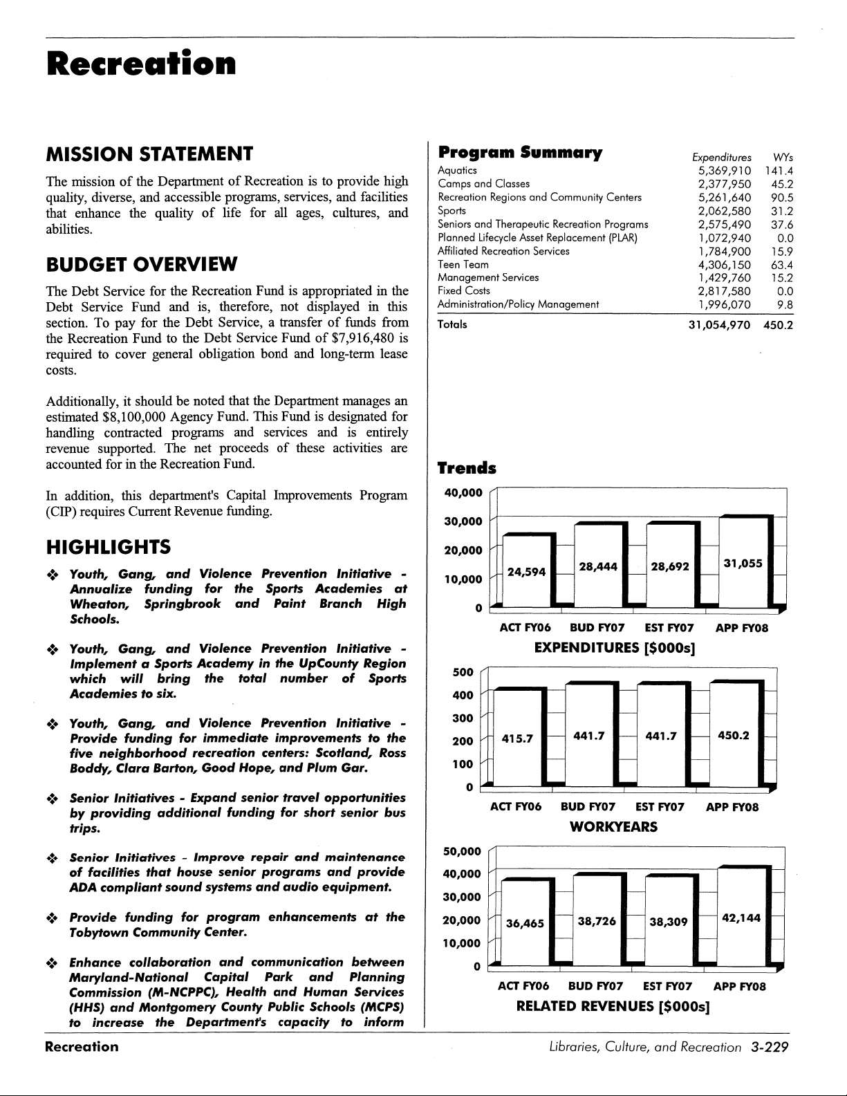
Walking the Map PDF Free Download
1 / 23/23
100%

Vol. 26, No. 1 International Journal of Multicultural Education 2024
8
Walking the Map
Kimberly Powell
The Pennsylvania State University
U.S.A.
ABSTRACT: In this article, I discuss how walking as mapping serves as a method
for observing and disrupting spatial geopolitics, opening possibilities for
alternative systems of living. I explore three theoretical perspectives—
posthumanism, Indigenous and decolonializing theories of land, and Black
geography—that, while distinct, nonetheless share some overlapping
characteristics: the recognition and contestation of knowledge systems, the turn
toward a relational ethics of living, and a call for critical and creative methods of
intervention into existing systems. In the final half of the paper, I consider these
orientations and their call for creative and critical methods of intervention as I
review my scholarship on walking and how it has served as a form of counterstory
mapping.
KEYWORDS: Asian American studies, mapping, walking, qualitative research,
spatial racism
Mapping and Walking Methodologies
Posthumanist Walking and Mapping
Indigenous and Decolonial Walking and Mapping
Black Geographies, Walking, and Mapping
Walking’s More-than Interventions into Mapping
Walking San Jose Japantown: Counterstory Mapping
Notes
References
Author Contact
Many geographers and educational researchers have noted that, while
mapping orders spaces and places, its fixed categorization of data belies the
fluidity of spaces and places as experienced by their inhabitants. This concern has
led to research exploring how places and spaces are produced by human, animal,
and plant experiences, processes, and activities (e.g., Feld & Basso, 1996;
Gershon, 2017; Powell, 2010). These concerns grapple with the map as an
expressive form open to reinvention, in which the conventions of mapping, such
as legends, grids, and boundaries, are reformed or supplemented by new aesthetic
forms of spatial depictions. The uses, methods, and forms of such mapping in
qualitative research have been extensively written about across disciplinary fields,
including arts-based, sensory, cultural, community, asset, and participatory
mapping (see Duxbury & Redaelli, 2020).

Vol. 26, No. 1 International Journal of Multicultural Education 2024
9
In this article, I discuss how walking as a mapping practice serves as a
method for rupturing spatial systems and structures, thus opening possibilities for
alternative systems of living. I discuss three theoretical frameworks—
posthumanism, Indigenous and decolonializing theories of Land, and Black
geography—that while distinct, nonetheless share some overlapping
characteristics: the recognition and contestation of knowledge systems; the turn
toward a relational ethics of living; and a call for critical and creative methods of
intervention into existing systems. I consider these perspectives and their call for
critical and creative methods concerning my scholarship on walking as a means of
counterstory mapping (Dyke et al., 2020). I focus on education in its broadest
sense, occurring not just within schools but within communities, cultural
institutions, and the land. Thus, many of the examples in this paper draw from
scholars who conceive of education as occurring everywhere or whose thoughts
inform critical spatial and place-based politics for educational scholarship and
practice.
While I previously accounted for the important role of the sensory and the
embodied in mapping place politics in my collaborative research in the El Chorrillo
neighborhood of Panama City, Panama (Powell, 2010, 2008), I did not account for
the significant role that walking played in our inquiry, perhaps because I had
considered it a necessity for mapping rather than a process of and for mapping.
Initially, the purpose of walking through the streets of El Chorrillo was to mark our
area CAD maps to note existing structures, landmarks, streets, and social
activities. However, the act of walking produced what Deleuze and Guattari (1987)
describe as a line of flight, not an actual flight but a movement that perturbs existing
structures. Whether those structures are buildings or minds, a line of flight is an
abstract line of creative potential that (in our case) differentiated conventional
mapping methods, usage, and product to something embodied, fluid, and
performative: the walking and mapping, walking as mapping, are expressive forms
of place and space that are both actual and virtual – that is, in the process of being
actualized yet are also indeterminate. Walking in Panama was an embodied
mapping process that opened up the potential for thinking of mapping, as well as
geographies themselves, as something constantly differentiating from itself.
The consideration of walking as a means of expressive, actual, and in the
process of becoming holds important implications for educational researchers
concerned with race and ethnic studies; critical geography; diversity, equity, and
inclusion; and multicultural, international concerns. In the latter part of this article,
I describe my collaborative research project in San Jose Japantown, California
(U.S.) called StoryWalks, arguing that walking as a research method for
counterstory mapping facilitates an irreducible politics of both race and place: the
past, present, and future enacted through these storied walks highlight the
expressive, performative nature of democratic, inclusive ideals pertaining to
activism, redress, interdependency, community knowledge, collective memory
work, and advocacy in a historically marginalized community.
Vol. 26, No. 1 International Journal of Multicultural Education 2024
10
Mapping and Walking Methodologies
Mapping research has a well-established history of use in critical qualitative
research, employed in anti-oppressive and collaborative approaches to both
research processes and outcomes (Marx, 2023). Sherry Marx (2023)
acknowledges the creative and innovative contributions of such scholarship toward
more equitable research through the disruption of existing hierarchies of research
conduct as well as to understandings of place and space. Indeed, education
scholars have developed creative approaches for examining normalized racist
ideas and marginalized youth through sonic cartography (e.g., Gershon, 2017),
journey mapping (Annamma, 2018), hand-drawn mapping of teacher taskscapes
(Nolte-Yupari, S., 2020), counterstory mapping (e.g., Dyke et al., 2020; Taylor &
Helfenbein, 2009), and GIS mapping (Vélez & Solórzano, 2017). Scholars
examining social issues concerning children's geographies have worked with
similar methods, accounting for children's movement and sense of agency through
neighborhoods, schools, and communities through cognitive mapping,
photography, and digital media (e.g., Nespor, 1997; Taylor, 2017), or for
reimagining children's geographies amidst contemporary threats (see Lanouette &
Taylor, 2022).
As a research method, walking has a long history of practice across multiple
fields such as anthropology, the arts, architecture, philosophy, geography, and
participatory approaches to qualitative research. In the social science fields,
walking has often been used to study social-spatial relations such as mobility,
place, and urban design; experiential encounters with place, health, and nature;
settler colonialism and land use; and race, gender, and disability in relation to
movement. Walking interviews, tours, and "go-along" interviews (e.g., Carpiano,
2009; Kusenbach, 2003; Lynch & Mannion, 2016) are longstanding ethnographic
methods for both creating and understanding lived connections to place and local
knowledge. In both the social sciences and the arts, walking has been a method
for creative, critical inquiry; for creating embodied, sensory ways of knowing
(Ingold, 2011; Pink, 2015); as interventions into spatial narratives of place (Aoki &
Yoshimizu, 2015; Powell, 2019); as an artistic practice for mindful cultural activism
(Pujol, 2018); as an aesthetic practice of transforming and generating architectural
and landscapes (Careri, 2017); and as a creative methodology that opens to
speculative practices (Springgay & Truman, 2019). In this latter category are
experimentations with walking that subvert notions of walking as a privilege (and
for whom) to examine political and ecological migration, colonial settlerism,
racialized spaces, and place-based stories that counter formalized historical
narratives (e.g., Lasczik et al., 2023; Powell, 2022; Springgay & Truman, 2019).
Critical walking methodologies have considered walking as a form of
pedagogy in the broadest sense: the study of place as a form of public pedagogy
regarding citizenship (Powell, 2019); movement’s facilitation of sensory
relationships between bodies, spaces, and places; environmental and land politics;
Vol. 26, No. 1 International Journal of Multicultural Education 2024
11
and the interrogation of walking's normalcy of movement through the lens of queer,
feminist, and Crip theories (see Cutter-Mackenzie-Knowles & Rousell, 2022;
Springgay & Truman, 2019). Critical walking methodologists have also argued that
walking is complicated through geographical specificity. Motala and Bozalek
(2022), for example, have argued that walking methodologies in the Global North
do not translate to the Global South; they call for more global, multicultural
engagements with this methodology to interrogate the ways in which the specificity
of place is socially, politically, and materially entangled with walking. In these ways,
walking pedagogies might contribute to citizenship education, environmental
education, disability justice education, multicultural education, settler colonial and
land education, and social justice education through approaches that examine the
embodied politics of places.
The relationship between mapping and walking is not always evident in the
literature. Few publications explicitly address this relationship. Much of the
literature that overtly examines this relationship appears to focus on practical
matters of urban planning and streetscapes (e.g., Ortega et al., 2020; Rosvall &
Bergstrom, 2008). Several implicitly or explicitly suggest walking as a cartographic
practice suited for exploring the fluid, embodied, and emergent nature of place,
particularly when created through artistic practices (e.g., Lasczik et al., 2023;
Motala & Bozalek, 2022; O'Rourke, 2013; Springgay & Truman, 2019). In the
following sections, I examine three theoretical orientations and examples of
walking and mapping research that offer critical perspectives on walking and
mapping as methodological interventions into entangled knowledge systems of
geopolitics, racism, the environment, and conceptions of the human.
Posthumanist Walking and Mapping
Rosi Braidotti (2013) discusses the posthuman turn in the humanities, which
considers the intangible nature of human boundaries (e.g., of where life begins
and ends) and of all matter having agency. Braidotti argues that posthumanism
can help us re-think "the historical moment when the Human has become a
geological force capable of affecting all life on this planet" (2013, p.5). Questions
raised from posthuman perspectives include the boundaries of "human": where the
human ends and the "other" begins and the very assumptions upon which
humanism and its foundations for democratized and egalitarian promises rest. A
principal critique concerns the universal human, as described by a humanist
philosophy, that focuses on the Western, white, able-bodied male (e.g., DaVinci's
iconic Vitruvian Man) and an assumed species hierarchy; relatedly, a critique of
Western capitalist narratives of progress have also been countered with accounts
of precarious, relational entanglements with life on the planet that challenge human
time-scales (Braidotti, 2019; Haraway, 2016; Tsing, 2015). Braidotti (2019) calls
for developing critical methods that attend to how humans are embedded in
differential geopolitics.
Vol. 26, No. 1 International Journal of Multicultural Education 2024
12
A posthuman perspective underscores the inter-relations and entanglement
of species, ecosystems, and modernity. Feminist scholars, for example, have
emphasized concepts of entanglement, vulnerability, and precarity that a
posthuman perspective offers. Citing Marilyn Strathern's feminist, speculative
method, Donna Haraway (2016) argues that it matters what stories/theories/worlds
we tell other stories, theories, and worlds with. Haraway's concerns are with the
inseparability of thinking-with and being-with humans and nonhumans in a type of
tentacular relation, and she relies on a complex signifier, SF, to signal a playful
worldmaking built through Speculative Fabulation, Science Facts, String Figures,
and so on. Anna Tsing (2015, 2005) focuses on the precarity of ecosystems and
biodiversity caused by colonialism, plantations and slavery, land use and
ownership, and how modernity, global capitalism, racism, and the environment are
entangled, leaving some more vulnerable than others. Tsing’s intervention
strategies vary across her work but are perhaps best summarized as a plurality of
methods collectively referred to as the "arts of living" that point to interspecies,
tentacular, arboreal, and weather arts across academic fields of study, as
illustrated in her co-edited collection (Tsing et al., 2017).
Posthuman cartographies exist, many of which are informed by the arts and
multidisciplinary fields of study (e.g., Harmon & Clemans, 2009). Posthuman
walking methodologies include the work of Springgay and Truman (2019), Lasczik,
et al. (2023), and Taylor et al. (2023) and focus on the entanglement of geopolitics,
materiality, movement, embodiment, climate, and conceptions of the human.
Mapping the Posthuman City (Ahlert & Skowronnek, 2021,
https://posthumancity.com/) is an art installation that examines non-human
species in Berlin, Germany to examine how nature and cities affect each other,
how human infrastructures offer new animal habitats, and the material
relationships between architecture and animals. The resulting 4-channel
installation, consisting of maps, AI-generated video from citizen science data
archives, and animal sound archives from Berlin's Museum of Natural History,
reveals how algorithmic networks see nature and how they create new realities
through visualization. While walking isn't an explicit method, the project tracks
movements—walking, flying, creeping—to examine nature-city relations.
Indigenous and Decolonial Walking and Mapping
While place is central to walking and mapping research, Indigenous
scholars have critiqued the concept of place within settler colonial histories and
practices, wherein there is an attention to Indigenous understandings of land (e.g.,
Tuck & McKenzie, 2015) that include the consideration of nonhuman inhabitants
and how they determine place. In an analysis of territory and settlement of settler
states similar to posthumanist perspectives, there is a critique of human-
centeredness and the animacy that attends to all matter; yet, Indigenous scholars
such as Kim Tallbear (2012) argue that the vibrancy found in matter has always
been attended to by Indigenous peoples both in geological forces and animals and
Vol. 26, No. 1 International Journal of Multicultural Education 2024
13
not just in humans. Tuck and McKenzie (2015) argue that it is necessary to attend
to the "cracks and fissures through which Indigenous life and knowledge have
persisted and thrived despite settlement" (p. 8). Like Haraway, Tallbear also warns
about the stories we use to story our knowledge of the world. Genetics research,
for example, is viewed as the dominant epistemology regarding human origins
rather than as a white settler storytelling practice, a view of evolution that enacts
racist understandings of Indigenous peoples despite its efforts to undo racism by
proving that there is no biological category to race (Reardon & Tallbear, 2012).
Storying the land to make, name, and reconstruct places after colonization
is a practice and process discussed by several Indigenous scholars (Yi, 2016). In
exploring the literacies of the Land, Sandra Styres (Kanien'kehá:ka) acknowledges
how Indigenous landscapes are storied, forming spatial and temporal tracks left by
ancestors over time that can be read. "From the time we are born our stories
intersect and connect with other stories as we walk this earth" (Styres, 2019, p.
28). Overlapping layers of storied tracks are buried deep or near the surface. Yi
(2016) argues that storying the land enacts cartographies after colonization that
meld geography with Indigenous histories, wherein the past becomes pathways
through a storied landscape and the transmission of such stories and place names
becomes a means of cultural and physical survival in relation to colonial land
settlements and the remapping of boundaries and properties.
Indigenous practices of walking and mapping are numerous. One example
is the Indigenous Mapping Workshop Collective
(https://www.indigenousmaps.com/), which offers a virtual space for mappers to
share resources and training to map Indigenous lands so that Indigenous peoples
can practice land stewardship practices such as preservation. Mapping, the
collective write, "is critical to supporting Indigenous rights and interests,
decolonizing place and pace, and sharing Indigenous stories of the land"
(Indigenous Mapping Collective, 2021, para. 1). Australian Aboriginal walks are
often expressed through songlines (oral maps of the landscape), dreaming tracks,
and song spirals; sometimes the depictions are a means of maintaining pathways,
stories, songs, passages, and cartographies (Norris & Harney, 2014). Artist
Dorothy Napangardi describes her paintings of women's walking and singing
across Country1 as an invitation for placing oneself in movement, a mapping of
passages rather than territory. Country is not simply representative of land, but
"has awareness" and animacy (Gay'Wu Group of Women, 2019, p. xxii, cited in
Lasczik et al., 2023).
Black Geographies, Walking, and Mapping
Katherine McKittrick examines how questions of race and Blackness inform
"geographic thought" (Hudson & McKittrick, 2014, p. 234). What happens, she
asks, when we notice how our intellectual politics, our systems of knowledge, "are
deeply embedded in practices of territorialization" (p. 234)? More recently,
McKittrick (2021) has written about how the "types and kinds of geographic terms
Vol. 26, No. 1 International Journal of Multicultural Education 2024
14
such as space, location, position, and mapping are utilized without attending to the
politics that underwrite these terms." Modernity and the map, underpinned by
Transatlantic slavery and colonialism, situate Black people and places outside of
modernity. Existing spatial concepts and theories, in other words, serve to
normalize social inequalities and uneven geographies (McKittrick, 2021). Black
geographies—the slave plantation, urbicide, the prison, transatlantic slavery and
slave ships, and slave quarters, among others—are predicated on spatialized
violence and the erasure of a Black sense of place (McKittrick, 2011). McKittrick
(2006, 2011) highlights how slavery prompted alternative mapping practices during
and after the transatlantic slave trade that existed in an alternative space to 'real'
maps: fugitive maps, literacy maps, family maps, and music maps, among others.
Writing about these challenges, McKittrick asserts that critical interventions
employing creative aesthetics and emphasizing relational and connective
knowledge might address the call to observe an existing social system (such as
mapping and its inherent social and physical ordering). Such interventions might
call out a social system’s normalcy, thereby potentially providing new conditions to
rupture an existing social system and build different living systems from the
"'something else' that is always ‘going on’" (Wynter, 2003, cited in McKittrick, 2016,
p. 9). Such techniques, she warns, must also be wary of falling back into existing
systems of knowledge.
An example of walking and mapping techniques that engage the public in
conversations about race and spatial narratives is artist Walis Johnson's The Red
Line Archive and Labyrinth. Johnson's work focuses on the history of redlining
practices, an illegal yet sustained practice of coding and delineating
neighborhoods to evaluate risks for real estate development, and the systematic
denial of loans and mortgages, among other financing to those living in certain
coded areas (see more description, below) based on race or ethnicity. For one of
her public art projects, Johnson created a maze from red ribbon to connote the
once-redlined area that now houses the Weeksville Heritage Centre in Brooklyn,
New York. Participants walked this red line with the artist as a means of
countermapping that questions racist and classist mapping practices while
generating conversation about new Black geographies (as well as communities of
color and the working class) of New York (WalkingLab Podcast Episode 2:
https://walkinglab.org/podcast/walking-as-counter-mapping). In their WalkingLab
podcast series, Springgay and Truman (2019) reference McKittrick in their analysis
of Walis Johnson's project. Their reference serves to examine Black geography as
placelessness and to emphasize the artist's method of intervention.2
Walking’s More-than Interventions into Mapping
What interests me about walking and mapping in the above theoretical
perspectives and research are three areas of concern for mapping research. The
first involves exploring a “more-than” perspective, a call to inquire into the more-
than-human and more-than-meets-the-eye. This challenges the conventional
Vol. 26, No. 1 International Journal of Multicultural Education 2024
15
understanding of the human category, contesting it along the lines of racism,
capitalism, and the interconnectedness of ecosystems via veins, roots, rhizomes,
creatures, weather, commerce, materials, and other matter. A more-than-human
cartography suggests a mapped account that looks less like grid lines and more
like collaged time-spaces, less like nation-state boundaries, and more like walking
and flight paths with interspecies lines of movement and border crossings. The
second concern examines the onto-epistemology of research methodologies. The
theories that frame and guide them should be critically observed so that we
recognize and attend to a knowledge system's normalcy and its sedimented
inequities and beliefs. This involves questioning who is forcibly expelled from the
category of 'the human' and, consequently, from various urban, rural, suburban,
woodland, and tourist spaces, including homes. The third concern calls for
interrogating normalcy through creative interventions. Interrogating normalcy—
taken-for-granted systems of knowledge—can involve employing creative
aesthetics and interventions to unsettle and make possible new social conditions.
Walking can intervene in mapping's system of knowledge by foregrounding
movement, story, paths, and performative elements of life, emphasizing relational
and connective knowledge to people, species, and land. Through walking, a map
might start to differentiate from itself, offering new insights and perspectives. The
examples cited in the previous section are a sample of the wide variety of critical
approaches to addressing such questions.
In my walking research, I have analyzed the intertwined relationship of
walking and storytelling in the historic neighborhood of San Jose Japantown,
California (U.S.). Because I have previously discussed Indigenous practices of
mapping and walking and their connection with storying, I acknowledge the Tamien
Nation, whose citizens have direct lineages to precontact villages of the Greater
Santa Clara Valley and were there long before white settlerism and immigration
established the city of San Jose and its surrounding areas. My research focuses
on Asian American immigration and the neighborhood of San Jose Japantown;
therefore, I do not explicitly address Indigenous land politics or the storying and
mapping of the land by the Tamien Nation. My walking research starts with the
historical, racial, and politically motivated discrimination of Asian Americans, with
a particular focus on Japanese Americans, rather than on indigeneity, land, and
settler occupation. Secondly, while my research focuses on Asian Americans living
in Japantown, I recognize the significant scholarly contributions of Black
geographers in arguing that U.S. racial and economic inequalities are definitively
spatial and that, beyond mere recognition of inequalities such as those found in
redlining, interventions are needed to create new possibilities. These scholarly
insights affect my own inquiry. My concerns have focused on the spatial racism
inflicted by the redlining of Japantown and the forced incarceration of its residents
during World War II, which displaced thousands of Japanese American residents,
and how the seemingly mundane gestures of a walk might matter for critical place
inquiry (Powell, 2022). With these concerns in mind, I discuss below how walking
serves as a process and practice of counterstory mapping.
Vol. 26, No. 1 International Journal of Multicultural Education 2024
16
Walking San Jose Japantown: Counterstory Mapping
A research project in collaboration with my community research partner and
a long-time resident of Japantown, PJ Hirabayashi, our StoryWalks project
consisted of asking neighborhood residents to take us on a walking tour of the
town. Over three years, we engaged in about 30 StoryWalks with individuals, pairs,
or small groups, ranging in ages from 5 to 91 years. We realized early on that while
a walk through town is a patterned habit—e.g., walking from one's apartment to
the market—the opportunity to reframe a walk as a tour could serve to defamiliarize
walking habits, yielding stories that, in many ways, counter-mapped specific
locations across time and place. Defamiliarization is a technique for dislodging
habits, preconceptions, and assumptions that involves experimentation with new
practices that allow for multiple processes and outcomes (Braidotti, 2013). While
we hadn't intentionally utilized the technique of defamiliarization, our extensive
walking tours nonetheless created opportunities wherein participants would reflect
on how they were able to see the neighborhood with a new perspective and,
importantly, see walking as a connective tissue among sites as well as histories,
other places, and timescales. As a result, the walks became practices of
counterstory mapping. Counterstorying employs community knowledge, traditions,
collective memory work, autobiography, and critical historical research; rather than
validating one story over another, counterstories seek "to complicate
understanding of the truth" (Atwood & López, 2014, p. 1145). Countermapping
recognizes mapping as a political practice of nation-state control regarding
dominant, often colonial views of territory and often employs cartographic
techniques to create culturally informed knowledge of place (Halder & Michel,
2018).
In the 1930's, the Federal Housing Administration (FHA) promoted home
ownership through federally backed loans as part of President Roosevelt's New
Deal to stimulate the economy. In 1934, the FHA Underwriting Handbook
incorporated “residential security maps” into their standards to determine where
mortgages could or could not be issued. These maps listed neighborhood
characteristics like "inharmonious racial or nationality groups" alongside "Smoke
and odor" (Jackson, 1980, pp. 435-436). Developed by the Home Owner's Loan
Coalition (HOLC) and used by the Federal Home Loan Bank Board to deny lending
and investments to minorities, these were color-coded maps—Green for "Best"
and Red for "Hazardous"—to indicate the level of security for real estate
investments in 239 American cities (Mitchell & Franco, 2018, p. 20). Redlining
derives from the practice of drawing a red line on a map to delineate areas where
financial institutions would not invest or back mortgages based on racial, ethnic,
and religious composition without regard to residents' qualifications or
creditworthiness (The Fair Housing Center of Greater Boston, 2021).
Neighborhoods predominantly made up of African Americans, Catholics, Jews,
and immigrants from Asia and southern Europe were deemed undesirable.

Vol. 26, No. 1 International Journal of Multicultural Education 2024
17
The discriminatory practices captured by the HOLC maps continued until
1968, when the Fair Housing Act banned racial discrimination in housing.
However, as Rothstein (2017) notes, redlining was a state-sponsored system of
segregation that has impacts on communities today. A study released by the
National Community Reinvestment Coalition (Mitchell & Franco, 2018) showed
that the vast majority of neighborhoods marked "hazardous" in red ink on maps
drawn by the federal Home Owners' Loan Corp from 1935 to 1939 are today much
more likely than other areas to comprise lower-income, minority residents, locking
neighborhoods into concentrated areas of poverty. San Jose was one of those
redlined cities, and Japantown was a redlined neighborhood. Figure 1 is a 1937
map showing the HOLC color codes for neighborhoods of San Jose. Figures 2 and
3 are a contemporary map of San Jose and an overlay of the original redlined area
on today’s Japantown, respectively.
Figure 1
A 1937 A San Jose "residential security map" and a closeup of the map legend,
created by the Home Owners' Loan Corporation [Map].
https://joshbegley.com/redlining/
Vol. 26, No. 1 International Journal of Multicultural Education 2024
18
Figure 2
Map of Japantown. Google Maps, 2015.
Figure 3
Begley, J. (n.d.). Redlining California [Digital Map].
https://joshbegley.com/redlining/
Vol. 26, No. 1 International Journal of Multicultural Education 2024
19
Another significant event was the internment of over 120,000 Japanese
Americans in 1942 under Presidential Executive Order 9066, issued after the
Japanese bombing of Pearl Harbor (Powell, 2022). This order served to empty San
Jose Japantown of many of its residents, housing, and businesses. Executive
Order 9066 called for the relocation of approximately 120,000 Japanese American
citizens along the Pacific coast to what is commonly referred to as internment
camps and relocation centers, although many today take issue with the language
and seek to call them concentration camps (see, for example, the Japanese
American Incarceration collection at the National Museum of American History).
These 10 relocation centers were built in remote, desolate areas far inland,
typically in desert-like conditions, imprisoning Japanese Americans in
concentration camps across the United States, scattering families, destroying
businesses, and violating U.S. citizenship.
Japantown today is home to Japanese Americans, Chinese Americans,
Filipino Americans, and Latino Americans. It is also home to The Japanese
American Museum of San Jose (JAMSJ), which houses archives from the
internment, including an installation of a barracks created by a resident of
Japantown who was interned as a young man. Additionally, numerous historical
plaques, signs, public memorials, and art installations refer to immigration,
settlement, internment, and individuals who resided in the town. These sites serve
as intentional forms of public pedagogy, designed by residents and civic planning
boards to educate those embarking on self-conducted or docent-led tours of the
town about its history and Asian immigrant settlement. Moreover, an annual Day
of Remembrance (DOR) is observed on February 19th, marking the day that
Executive Order #9066 was signed and authorized the Japanese American
internment. On this day, reflections and personal stories about the internment and
its impact on the loss of civil liberties are shared, alongside discussions about its
implications for contemporary civic life. The event, for example, has extended its
support to movements like Black Lives Matter. A national event, the San Jose
Japantown DOR is hosted by the neighborhood's Buddhist Church, featuring guest
speakers from civil rights groups, politicians, and those who were incarcerated. As
part of the event, there is a candlelit, silent walk through the main street of the town
for remembrance and reflection.
Many stories shared during our walks intertwined identity politics
concerning the illegal mortgage lending practice of redlining and, notably, the
Japanese American internment issued via Presidential Order #9066, policies and
practices of spatial racism that profoundly impacted the neighborhood. Several
walking participants reflected on Filipino, Chinese, and Japanese immigration to
the Santa Clara Valley and the Japantown area, highlighting policies and events
that physically shaped its borders and buildings. For instance, the Chinese
Exclusion Act of 1882 and The Immigration Act of 1924 limited the number of
immigrants allowed entry into the United States through a national origins quota
that excluded Asian immigrants altogether, aiming to "preserve the ideal of U.S.
homogeneity" (Office of the Historian, 2021, para. 8). Although matters of public
and historical record, these policies were interwoven into many participant stories
as they walked PJ and I to medical and law practices, churches, and business
Vol. 26, No. 1 International Journal of Multicultural Education 2024
20
centers within Japantown. During one walk, José Muriera, then President of the
South Bay Filipino Society, elaborated on the shared history of discrimination that
gave rise to a Pinoy town and Chinatown adjacent to Japantown, which provided
safe spaces for these immigrant groups.
Among our walking tours, many participants visited the same public stops:
the museum; the memorials and monuments at the center intersection of town;
several historic buildings such as the Issei Memorial building; the Ikoi no Ba
benches, peaceful places for reflection symbolically marking five moments in
Japanese American history—internment, festivities, farming, immigration, and
culture (Japantown Business Association, 2021); Hori Midwife house; Roy's Café,
a coffee shop in the middle of Japantown; San Jose Buddhist Church Betsuin; the
Wesley United Methodist Church; the Corporation Yard that was once Chinatown
(and now current holds a Civic Center); and Okida Hall, a former theater and
rehearsal space but now an Ethiopian Church. However, the pathways, routes,
and stories they shared differed remarkably, punctuated with personal accounts,
past and current events, and future imaginings; and, of course, other sites unique
to each participant. Effectively, the stories individually and collectively collaged and
threaded together spatial-temporal dimensions of place that belie any single
narrative or map.
Counterstory-mapping Incarceration
The counterstory mapping (Dyke et al., 2020) that occurred through walking
is best described through the stories themselves. Several of our walking
participants referred to internment, with a few experiencing incarceration directly:
Jimi, Joe, and Arlene are three such participants, whose accounts are briefly
described here. Jimi, 91 years old at the time of our walk (and since deceased),
was imprisoned at age 20. A volunteer docent, curator, and contributing artist at
the Japanese American Museum of San Jose, Jimi's tour included a barrack room
installation built from blueprints, photographs, and his memories. Jimi's walk was
full of historical accounts. At one point, we went to one of the museum's offices so
that he could share some historic maps of the area. Joe, also a volunteer docent
at the museum and in his late 70s at the time of our walk, took me on a 2-hour
walk through the museum rather than through the neighborhood; our walk
entwined the museum's exhibitions with Joe's personal stories of incarceration as
he described his experiences as a boy in the camps. We viewed aerial maps and
photographs of the prison camps, as well as many other exhibits. At one point, Joe
pointed to an aerial photograph of the barracks where he and his family were
imprisoned. His father, a U.S. government translator for the immigration
department, was arrested when Joe was just 9 years old. Deemed a security threat
due to his duties, his father was sent to a high-security camp for dangerous
prisoners. Joe, along with his mother and three siblings, were sent to a different
camp, where he did not see his father for two years.
Vol. 26, No. 1 International Journal of Multicultural Education 2024
21
Arlene began her tour of the store by telling the story of how she and her
siblings were born in the Japanese American Topaz detention camp. Coming from
a long line of merchants, reaching five generations back, Arlene's father came from
Japan to the States and set up his store initially in San Francisco in 1902 before
relocating to Japantown. During WWII, her father helped manage a cooperative
department store at the Topaz, Utah detention camp, where Arlene and one of her
brothers were born. Notably, Arlene described her store as a "quasi-museum,"
explaining, "We figured we have history, [so] we're going to share it with people.
Plus, it gives us an opportunity to talk about internment because many people in
our country still don't know." Among the archives in her store are customer-signing
books dating back to 1939, initiated by her father out of human interest.
Occasionally, someone viewing these books will recognize a name. While Arlene
has donated some of her archives to the local museum, she has several different
collections, many of which have been consigned. She refers to the items that come
into her store as "cherishables," including plates, ochawan (rice bowls), yukatas,
kimonos, textiles, and her grandfather's hand-drawn sketches of hats, gloves, and
shoes transferred to metal engravings for printing advertisements for the store.
She pointed to a photo of her father and his unauthorized home movie taken while
in the prison camp, the only one ever made. Her father and his films were featured
in a later documentary, she explained, accepted into the national registry in 1996,
the second only private film ever accepted after Abraham Zapruder's Kennedy
assassination short film. She also shared a news clipping about her brother, who
helped carry the 2002 Olympic torch through Twin Falls, Idaho. Eventually it would
end up in Salt Lake City, Utah, where her brother had spent the first three years of
his life in the Topaz prison camp, Arlene noted.
The walks led by Jimi, Joe, and Arlene served to map the policies and
places where racialized bodies were labeled as the criminal other, deemed
undeserving of citizenship. Yet, their personal stories, which accompanied these
walks, also mapped their creative engagement in founding and developing both
formal and informal museums, serving as docents, participating in civic programs
like the annual Day of Remembrance, and, in Jimi’s case, creating museum
installations and other public art projects. These endeavors actively resist any
singular narrative regarding place and race politics. Jimi, Joe, and Arlene
demonstrate a critical understanding of the pedagogical imperative in their
pursuits, each of which fosters open-ended gatherings, connecting people and
history across different times and places.
Counterstory-mapping Redress, Reformation, and Development
At the request of PJ, my community research partner, we conducted
numerous walks with community activists from Japantown's Sansei (third)
generation, who were born after World War II and engaged in activities related to
redress, reparation, and redevelopment, alongside younger generations. In this
section, I highlight a few individuals who contributed to our research: Duane, a
Vol. 26, No. 1 International Journal of Multicultural Education 2024
22
documentary filmmaker and retired professor; Susan, a civil liberties activist and
member of the Nihonmachi Outreach committee; Carol, a local business owner
and lifelong resident; Tamiko, Carol’s daughter and a local artist; Matt, a performer
in San Jose Taiko with long-term involvement in the town’s cultural events; and
Ken and PJ, both of whom led separate artwalks for young children.
Both Duane and Susan separately discussed the Issei Memorial building,
formerly a Japanese American hospital that served individuals rejected by the San
Jose hospital due to racial discrimination. It has since been repurposed as a civic
office building hosting numerous cultural organizations. They highlighted its role
as an incubator over time, fostering ideas for the community's future. For instance,
Duane recalled its use as a meeting place for young activists in the 1970s. As he
explained, "These meetings gave birth to San Jose Taiko, Asian Law Alliance, Yu-
Ai Kai [the local senior center]. It's really kind of an incubator, I think, and still acts
as an incubator today for community ideas" (Powell, 2022, p. 263). Susan also
mentioned how redlining drew the boundaries and containment area that became
the neighborhood known as Japantown. Despite its origins in racist and
discriminatory practices, she emphasized how such boundaries provided safe
spaces and opportunities for civic practices, organizations, businesses, and
political movements, including reparations and redress measures.
Carol, a local business owner who grew up in Japantown, spoke of a
relational ethics of care and sustainability within the community and for the
preservation of the main street's environment. During our walk, she pointed out
buildings that once housed businesses, as well as relatives' and friends'
residences. Notably, her family's café occupies the space where her father's gas
station once stood—an important historical landmark for many residents. In tribute
to her father's business, she named her café "Roy's Station.” As a business owner,
Carol collaborates with others to avoid duplicating specialty items sold by
neighboring businesses, emphasizing her consciousness for the other
establishments. Her ethics of sustainability and community care extends to
nurturing the plants long the main street’s stores and sidewalks with coffee
grounds from her café and the local tofu shop (which, at the time of this writing, no
longer exists), as well as bat guano. She notes that the city trees and storefront
plants would not have survived the drought—a climate event that occurred during
the time of our walk – without her efforts.
PJ and I walked with several artists, including Carol's daughter, Tamiko,
who worked at Roy's Station along with her seven siblings and is also a local
website designer, tattoo artist, and community artist. She described her visions
and activities as an artist and a long-time community member with extensive family
connections. In addition to walking me through the main street to point out graphic
design and banners designed by family and friends, she also walked me to the
Corporation Yard, which at the time of the walk was a fenced-in, empty lot. It had
also been the site of her Japantown Mural Project. Hired by the city of San Jose,
she coordinated an effort that included 60 9x6 foot panels created by over 50
artists; they covered the fencing that spans the length of Jackson Street between
6th and 7th Streets, so that people could walk down the street and see other artists
Vol. 26, No. 1 International Journal of Multicultural Education 2024
23
who are from Japantown. Other artists include several from the San Jose Taiko
ensemble, a group that PJ and her husband, Roy, cofounded in 1973 with others
to create performances and educational programming to empower diverse voices
and build cultural understanding (see https://taiko.org/mission). Like Duane and
Carol, Tamiko’s stories and tour referred to a diverse racial and ethnic past,
present, and future hope for what Duane termed a “multicultural community.”
Tamiko discussed the history of the neighborhood, which had been historically
Chinatown and also had a large Filipino community as having an ethnically
inclusive sensibility. For her, Japantown isn't about specific racial and ethnic
groups but rather a common history that is important to the identity of the
neighborhood and respect for that history. Her vision for Japantown was an
inclusive one, involving the maintenance of a small business atmosphere.
One San Jose Taiko performance member, Matt, described how taiko
drumming sonically mapped and brought together the neighborhood during their
annual Obon festival performances, commenting on the corresponding time-lapse
videos of Obon, in which hundreds of festival goers would ebb and flow at the
sound of the drumming performance. Beyond that specific event, a few walking
participants from the group commented on how drumming acted as a sonic
presence of ethnic and community identity that mapped an undeniable and vibrant
presence—a sonic cartography of a living community.
In contrast to these participant-led walking tours with multi-generational
adults, PJ and I also organized two art walks with young children and their teacher
from the local preschool. PJ, who co-founded San Jose Taiko and is still active
with taiko (see https://taikopeace.love/) led a sound walk in which she and the
children listened to the sounds in their neighborhood, locating and placing sounds;
they created their own sounds and discussed the city sounds that they didn't hear
during the walk yet comprised the city's soundscape. During another art walk, the
children walked with Ken, a local stone artist, visiting several stone sculptures, the
World War II internment memorials, and Ken's studio to touch and listen to the
sounds of stone. They also made clay impressions and crayon rubbings of textures
during our walk. These were stories produced by the spatial geographies of
children.
These are but a few of the many StoryWalks that occurred as part of our
project. Separately and together, the walking paths and stories countermap what
Caroline Chung Simpson (2002) refers to as an "absent presence" (p. 3), a
dominant representational narrative of Japanese American economic and social
disenfranchisement caused by internment, relocation, and Cold War culture
figured a haunted identity. Simpson argues that nation-state narratives diminish
the complexity of political and historical experiences and that an absence is
created through the loss of situated particulars. McKittrick's (2021) insights
regarding spatial concepts and theories that normalize social inequalities
underscore the geopolitics of narratives. Taken together, these arguments suggest
that dominant narratives have a spatial component of placelessness for minoritized
citizens.
Vol. 26, No. 1 International Journal of Multicultural Education 2024
24
These counterstory maps methodologically unsettle dominant narratives of
community, ethnicity, racial identity, and place. The map in Figure 4 depicts the
mapped storylines and paths of some of the walks using an app called Runkeeper,
which depicts movement with red lines. These red lines do not symbolize
“hazardous demarcations” found in the historic maps; I have juxtaposed 12 of
these walking routes onto a redlined map of Japantown, part of a larger map of
San Jose created by artist Josh Begley (n.d.), as well as an image of a Civilian
Exclusion Order, a flyer posted on storefronts and telephone poles containing
instructions for the evacuation and relocation of those of Japanese ancestry, a
replica of which still hangs as an archive on a telephone pole in the neighborhood.
Doing so allows me to foreground red lines of speculation, fabulation, facts, hopes,
dreams, trauma, memories, memorialization, mourning, wanderings, and voluntary
movements. Using the aesthetics of collage in Figure 5, I collapse time, space,
and borders, creating a field of co-existing images that are at once in tension and
in relation with one another. Rather than emphasizing borders and boundaries,
these maps make visible lived stories across time, space, and place, evocative of
lived experiences with displacement, redress, and new social conditions, as well
as new lines.
Figure 4
Powell, K. Walking and mapping red lines. [Digital Collage].
Vol. 26, No. 1 International Journal of Multicultural Education 2024
25
Figure 5
Powell, K. Walking Japantown. [Digital Collage].
StoryWalks participants created place-based stories weaving personal and
collective memories of specific buildings, streets, businesses, people, sounds,
smells, images, empty lots, and blank walls. Facts don't hold still among these
various agents. Cyndi Katz's (2004) concept of "countertopographies" recognizes
both the specific attributes of places and their analytic connections to other places
through what she refers to as contour lines: particular relations to a process (e.g.,
global streams of capitalism). Story, in this view, is more than just a human,
discursive event, it is a thing made through an experience of unfolding relations
moving beyond a particular place and time, producing a more-than-human
cartography even while stories are intimately bound in and with humans. The
StoryWalks countermapped what Lipsitz (2007) refers to as a white spatial
imaginary centered on settlerism, economic competition, and racist demarcations
of places and people. Instead, the StoryWalks highlighted a relational ethics of
community care and sustainability. That aligns well with Haraway’s (2016) concept
of ‘response-ability,’ a matter of not just responding, but responding well toward
how we are entangled in our relations with others. For Haraway, this is created
through our relations with others, and it is inventive, uncertain, and precarious. The
participants’ countermaps revealed a response-ability towards people, buildings,
landscapes, business plans, stories spanning past, present, and future, public art,
memorials, as well as archives collected and maintained by a museum and
Japantown’s citizens.
Maps and mapping function as assemblages (Deleuze & Guattari, 1987)
composed of an interaction between the corporeal (the material, the physical) and
noncorporeal, or the immaterial (movement, space, sensation), performatively

Vol. 26, No. 1 International Journal of Multicultural Education 2024
26
enunciating our presence in and with the world. The performative potential of
walking refers to its expressive and pedagogical function, limited not just to the
usual ways we think of movement as bodies, materials, and objects traveling
through space and time, but to an expanded notion of movement as that which
produces difference: to become something other than itself wherein it might
interrogate notions of the human; to become counterstory mappings; to arrange
geopolitics of histories, memories, lived experiences and places across time and
space. A line, a map, a story, a walk: they are inseparable. All compose a
countercartography hinging on movement that fluxes fast and slow, here and there,
in habitual patterns and spontaneous wanderings.
1 Country is a term often used by Aboriginal and Torres Strait Islander people that,
while holding many meanings, connotes interconnections among people, land,
waters, skies, and ancestry. Pol (2023), among others, states that Country is a
proper noun in the same way that a person is and is thus capitalized: “Country is
alive. Country is timeless. And Country is us.” As defined on the AIATSIS (2024)
website, Country “contains complex ideas about law, place, custom, language,
spiritual belief, cultural practice, material sustenance, family and identity.” Videos
of Ngunnawal Elder Jude Barlow describing the significance of Country can also
be found at https://aiatsis.gov.au/explore/welcome-country
2 For a comprehensive resource on redlined maps, see Mapping Inequality:
Redlining in New Deal America, a website that provides interactive redlined maps
of the racial and ethnic discrimination in U.S. housing policies. See
https://dsl.richmond.edu/panorama/redlining.
References
Ahlert, M. & Skowronnek, A. (2021). Mapping the posthuman city. Installation,
Berlin Germany. Retrieved from https://posthumancity.com
AIATSIS (n.d.). Welcome to Country. The Austrailian Institute of Aboriginal and
Torres Strait Islander Studies. https://aiatsis.gov.au/explore/welcome-
country
Annamma, S.A., 2018. Mapping consequential geographies in the carceral state:
Education journey mapping as a qualitative method with girls of color with
dis/abilities. Qualitative Inquiry, 24(1), 20–34. https://doi.org/10.1177/
1077800417728962
Aoki, J. & Yoshimizu, A. (2015). Walking histories, un/making places: Walking
tours as ethnography of place. Space and Culture, 18(3), 273–284.
https://doi.org/10.1177/1206331215579719
Atwood, E. & López, G. R. (2014). Let’s be critically honest: Towards a messier
counterstory in critical race theory. International Journal of Qualitative

Vol. 26, No. 1 International Journal of Multicultural Education 2024
27
Studies in Education, 27(9), 1134–1154.
https://doi.org/10.1080/09518398.2014.916011
Begley, J. (n.d.). Redlining California: 1936-1939. https://joshbegley.com/redlining/
Braidotti, R. (2013). The posthuman. Perlego.
Braidotti, R. (2019). Posthuman knowledge. Polity Press.
Careri, F. (2017) Walkscapes: Walking as an aesthetic practice. Culicidae
Architectural Press.
Carpiano, R. (2009). Come take a walk with me: The “Go-Along” interview as a
novel method for studying the implications of place for health and well-
being. Health & Place, 15(1), 263-272.
https://doi.org/10.1016/j.healthplace.2008.05.003.
Deleuze, G. & Guattari, F. (1987). A thousand plateaus: Capitalism and
schizophrenia. University of Minnesota Press.
Duxbury, N. & Redaelli, E. (2020). Cultural mapping. In Moy, P. (Ed.), Oxford
Bibliographies in Communication.
https://doi.org/10.1093/OBO/9780199756841-0249
Dyke, E.L., El Sabbagh, J., & Dyke, K., 2020. “Counterstory mapping our city”:
Teachers reckoning with Latinx students’ knowledges, cultures, and
communities. International Journal of Multicultural Education, 22 (2), 30–45.
https://doi.org/10.18251/ijme.v22i2.2445
Feld, S. & K. Basso, K. (Eds.), Senses of place. School of American Research
Press.
Gay’wu Group of Women, Burarrwanga, L., Ganambarr, R., Ganambarr-Stubbs,
M., Ganambarr, B., Maymuru, D., Wright, S., & Lloyd, K.
(2019). Songspirals: Sharing women's wisdom of Country through
songlines. Allen & Unwin.
Gershon, W. S. (2017). Sonic cartography: Mapping space, place, race, and
identity in an urban middle school. Taboo: The Journal of Culture and
Education, 13 (1). https://doi.org/10.31390/taboo.13.1.04
Halder, S. & Michel, B. (2018). This is not an atlas. Retrieved from
https://notanatlas.org/book/
Haraway, D. (2016). Staying with the trouble. Duke University Press.
Harmon, K. & Clemans, G. (2009). The map as art: Contemporary artists explore
cartography. Princeton Architectural Press.
Hauser & Wirth. Allan Kaprow, paintings New York. Retrieved from
https://www.hauserwirth.com/hauser-wirth-exhibitions/6234-allan-kaprow-
paintings-new-york/
Hudson, P.J. & McKittrick, K. (2014). The geographies of Blackness and Anti-
Blackness. The CLR James Journal, 20(1/2), p. 233-240.

Vol. 26, No. 1 International Journal of Multicultural Education 2024
28
Ingold, T. (2011). Being alive: Essays on movement, knowledge and description.
Routledge. https://doi.org/10.4324/9780203818336
Jackson, K. T. (1980). Race, ethnicity, and real estate appraisal: The Home
Owners Loan Corporation and the Federal Housing Administration. Journal
of Urban History, 6(4), p. 419–52.
Katz, C. (2004). Growing up global: Economic restructuring and children’s
everyday lives. Minneapolis, MN: University of Minnesota Press.
https://doi.org/10.1111/j.1467-8330.2009.00710.x
Kusenbach, M. (2003). Street phenomenology. Ethnography, 4(3), 455–485.
https://doi.org/10.1177/146613810343007
Lanouette, K. & Taylor, K. H. (2022). Learning within socio-political landscapes:
(Re)imagining children’s geographies. Occasional Paper Series, (48), 3-12.
DOI: https://doi.org/10.58295/2375-3668.1471
Lasczik, A., Cutter-Mackenzie-Knowles, A., & Rousell, D. (Eds.) (2023). Walking
as critical inquiry. Springer. https://doi.org/10.1007/978-3-031-29991-9_1
Lipsitz, G. (2007). The racialization of space and the spatialization of race:
Theorizing the hidden architecture of landscape. Landscape Journal, 26(1),
10–23. https://doi.org/10.3368/lj.26.1.10
Lynch, J. & Mannion, G. (2016). Enacting a place-responsive research
methodology: Walking interviews with educators. Journal of Adventure
Education and Outdoor Learning, 16(4), 330-345.
https://doi.org/10.1080/14729679.2016.1163271
Marx, S. (2023). Mapping as critical qualitative research methodology.
International Journal of Research & Method in Education, 46(3), 285-299.
https://doi.org/10.1080/1743727X.2022.2110231
McKittrick, K. (2006) Demonic grounds: Black women and the cartographies of
struggle. Minneapolis, MN: University of Minnesota Press.
McKittrick, K. (2011). On plantations, prisons and a Black sense of place. Social
and Cultural Geography, 12:8, 947–963.
https://doi.org/10.1080/14649365.2011.624280
McKittrick, K. (2016). Diachronic loops/deadweight tonnage/bad made measure.
Cultural Geographies, 23(1): 3–18.
https://doi.org/10.1177/1474474015612716
McKittrick, K. (2021). Dear science and other stories. Duke University Press.
https://doi.org/10.1515/9781478012573
Mitchell, B. & Franco, J. (2018). HOLC “Redlining” maps: The persistent structure
of segregation and economic inequality. https://ncrc.org/holc/
Motala, S. & Bozalek, V. (2022). Haunted walks of District Six: Propositions for
counter-surveying. Qualitative Inquiry, 28(2), 244-256.
https://doi.org/10.1177/10778004211042349

Vol. 26, No. 1 International Journal of Multicultural Education 2024
29
Nespor, J. (1997). Tangled up in school: Politics, space, bodies, and signs in the
educational process. Lawrence Erlbaum.
Nolte-Yupari, S. (2020). Working visually, mapping artfully: Taskscapes of the K-
12 beginning art teacher. Cultural Studies ↔ Critical Methodologies, 20(1),
43–51. https://doi.org/10.1177/1532708619885411
Norris, R. P. & Harney, B. Y. (2014). Songlines and navigation in Wardaman and
other Australian aboriginal cultures. arXiv preprint arXiv:1404.2361.
Office of the Historian. (2021). https://history.state.gov/milestones/1921-
1936/immigration-act
O’Rourke, K. (2013). Walking and mapping: Artists as cartographers. London and
Cambridge: MIT Press. https://doi.org/10.3390/arts3020298
Ortega, E., Martín, B., De Isidro, A., & Cuevas-Wizner, R. (2020). Street walking
quality of the ‘Centro’ district, Madrid. Journal of Maps, 16(1), 184-194.
https://doi.org/10.1080/17445647.2020.1829114
Pink, S. (2015). Doing sensory ethnography. Sage.
Pol, G. (2023). What is Country? Common Ground First Nations. Retrieved from
https://www.commonground.org.au/article/what-is-country
Powell, K. (2008). Remapping the city: Palimpsest, place, and identity in art
education research. Studies in Art Education, 50(1), 6-21.
https://doi.org/10.1080/00393541.2008.11518752
Powell, K. (2010). Making sense of place: Mapping as a multisensory research
method. Qualitative Inquiry, 16(7), 539-555.
https://doi.org/10.1177/1077800410372600
Powell, K. (2019). Walking as precarious public pedagogy. Journal of Public
Pedagogies, 4, 191-202. https://doi.org/10.15209/jpp.1188
Powell, K. (2022). Moving encounters with spatial racism: Walking in San Jose
Japantown. Qualitative Inquiry, 28(2), 257–266.
https://doi.org/10.1177/10778004211042345
Pujol, E. (2018). Walking art practice: Reflections on socially engaged paths.
Triarchy Press Ltd.
Reardon, J. & Tallbear. K. (2012) “Your DNA is our history.” Genomics,
anthropology, and the construction of whiteness as property. Current
Anthropology, 53(5), 233-245. https://doi.org/10.1086/662629
Rosvall, M. & Berstrom, C. (2008). Maps of random walks on complex networks
reveal community structure. PNAS, 105 (4), 1118-1123.
https://doi.org/10.1073/pnas.0706851105
Rousell, D. & A., Cutter-Mackenzie-Knowles. (2022). Posthuman research
playspaces: Climate child imaginaries. Routledge.
Springgay, S. & Truman, S. (2019). Walking methodologies in a more-than-human
world: WalkingLab. Routledge.

Vol. 26, No. 1 International Journal of Multicultural Education 2024
30
Styres, S. (2019). Literacies of land: Decolonizing narratives, storying, and
literature. In L. T. Smith, E. Tuck, and K. W. Yang (Eds.), Indigenous and
decolonizing studies in education: Mapping the long view. Routledge.
Tallbear, K. (2012). An Indigenous ontological reading of cryopreservation
practices and ethics (and why I’d rather think about pipestone).
www.kimtallbear.com/homeblog/an-indigenous-ontological-reading-of-
cryopreservation-practices-and-ethicsand-why-id-rather-think-about-
pipestone
Taylor Jr., L. H. & Helfenbein, R. (2009). Mapping everyday: Gender, Blackness,
and discourse in urban contexts. Educational Studies, 45(3), 319-329.
https://doi.org/10.1080/00131940902911006
Taylor, C., Hogarth, H., Cranham, J., Hewlett, S., Bastos, E., Barratt Hacking, E.,
& Barr, K. (2023). Concept-ing with the gift: Walking method/ologies in
posthumanist research. Journal of Posthumanism, 3(1), 13-31.
Tsing, A. L. (2005). Friction: An ethnography of global connection. Princeton University
Press. https://doi.org/10.2307/j.ctt7s1xk
Tsing, A. L. (2015). The mushroom at the end of the world: On the possibility of life
in capitalist ruins. Princeton University Press.
https://doi.org/10.2307/j.ctvc77bcc
Tsing, A. L., Swanson, H., Gan, E., & Bubandt, N. (Eds.) (2017). Arts of living on
a damaged planet: Ghosts and monsters of the anthropocene. University of
Minnesota Press. http://www.jstor.org/stable/10.5749/j.ctt1qft070
Tuck, E. & McKenzie, M. (2015). Place in research: Theory, methodology, and
methods. Routledge. https://doi.org/10.4324/ 9781315764849
Vélez, V., & Solórzano, D. (2017). Critical race spatial analysis. In D. Morrison, S.
Annamma, & D. Jackson (Eds), Critical race spatial analysis: Mapping to
understand and address educational inequity (pp. 8–31). Stylus.
https://doi.org/10.4324/9781003443896
Wynter, S. (2003). Unsettling the coloniality of being/power/truth/freedom:
Towards the human, after man, its overrepresentation – An argument. CR:
The New Centennial Review, 3(3), 257–337.
https://doi.org/10.1353/ncr.2004.0015
Yi, I. (2016). Cartographies of the voice: Storying the land as survivance in Native
American oral traditions. Humanities, 5(3), 62.
https://doi.org/10.3390/h5030062
Author Contact
Kimberly Powell, kap17@psu.edu