Marine Resources PDF Free Download
1 / 16/16
100%

Our Marine Water Bodies
PISCATAQUA RIVER
“The Piscataqua River ows 12.25 miles to the Gulf
of Maine through the towns of Eliot and Kittery,
Maine, and Dover, Newington, Portsmouth, New
Castle, and Rye, New Hampshire, functioning as
the state border between these two states.
The river gets its name from the Abenaki word
meaning, “a river with a strong current.”
- Wells Reserve at Laudholm
The Piscataqua River begins near Eliot’s northern
boundary, at the conuence of the Salmon Falls
and Cocheco Rivers. Passing Great Bay and I-95,
it widens into Portsmouth Harbor. The Piscataqua
Region Watershed is over 1,000 square miles,
almost all in New Hampshire and Maine. This
includes the Hampton-Seabrook Estuary; the
Piscataqua River Watershed itself is smaller
and located entirely in New Hampshire and Maine.
Boats on the Piscataqua
“Shipping along the river is very active, with
several million tons of cargo entering each year
for New Hampshire, eastern Vermont, and southern
Maine. Items include petroleum products, rubber
and plastics, iron and steel scrap, salt, limestone,
gypsum, and sh products. The harbor is used by
submarines from the Portsmouth Naval Shipyard
on Seavey Island in Kittery and for fuel deliveries
to Pease International Tradeport in Newington.
Additionally, Portsmouth Harbor is used
extensively by a large lobster shing eet,
charter shing vessels, commercial shermen,
excursion boats, and local and transient vessels
based at or visiting about 20 boating facilities.”
- Wells Reserve at Laudholm1
Eliot has about eight miles of shoreline on the
river, plus over another mile of shoreline along
Spinney Creek. With that much shoreline, we
have a responsibility to be good stewards of the
river and help ensure its water is clean.
Town of Eliot: 2025 Comprehensive Plan Marine Resources || 195
MARINE RESOURCES
Eliot is a coastal community. The Piscataqua River provides
direct access to the Atlantic Ocean, enabling saltwater
fishing, shellfishing, and recreation.
MARINE
RESOURCES GOALS
Healthy marine life and clean
water quality in the Piscataqua
River and its tributaries
A shoreline that people can
access for recreation,
enjoyment, and commerce
A shoreline and marine
environment that is
resilient to climate change
1
GOAL
2
GOAL
3
GOAL
See the end of this section for the full
table of goals, policies, and strategies.
Wells Reserve describes the river’s shipping activity:
Shipping along the Piscataqua River is very active,
with several million tons of cargo entering each year.

Town of Eliot: 2025 Comprehensive Plan Marine Resources || 196
FIGURE 11.1 MARINE RESOURCES
4
|
2023 STATE OF OUR ESTUARIES REPORT
Little
Bay
W
i
n
n
i
c
u
t
R
.
S
q
u
am
s
c
o
t
tR.
Great Bay
L
a
m
p
r
e
yR.
Bel
l
a
m
y
R
.
O
y
s
t
e
r
R
.
G
r
e
a
t
W
o
r
k
s R.
S
p
r
u
c
e
C
reek
P
i
s
c
a
taq
u
aRiv
e
r
C
o
c
he
c
o
R
.
Atlantic Ocean
Isles of Shoals
Portsmouth
Harbor
Hampton-Seabrook
Harbor
Sal
m
o
n
F
alls R.
Salmon Falls R.
E
x
e
t
e
r
R
.
No
r
th
B
r
anc
h
R
i
v
er
Is
i
ngl
a
ss
R
i
v
e
r
M
a
d
R
i
v
e
r
E
la
R
i
v
e
r
Pickers Brook
P
isc
ass
i
c
R
ive
r
T
aylor
Rive
r
L
i
t
t
l
e
R
i
v
er
§
¨¦
95
UV
101
SALISBURY
YORK
WELLS
ACTON
LEBANON
LEE
SANFORD
MILTON
DEERFIELD
STRAFFORD
DOVER
BERWICK
CANDIA
WAKEFIELD
BARRINGTON
ROCHESTER
NOTTINGHAM
EPPING
ELIOT
RYE
NEW
DURHAM
RAYMOND
DURHAM
FARMINGTON
CHESTER
EXETER
NORTH BERWICK
NORTHWOOD
KITTERY
KINGSTON
SOUTH BERWICK
BROOKFIELD
FREMONT
MIDDLETON
STRATHAM
HAMPTON
SANDOWN
BRENTWOOD
DANVILLE
MADBURY
PORTSMOUTH
NEWMARKET
GREENLAND
NEWINGTON
KENSINGTON
SEABROOK
NORTH HAMPTON
HAMPTON
FALLS
NEWFIELDS
SOMERSWORTH
EAST
KINGSTON
ROLLINSFORD
NEW
CASTLE
Piscataqua Region
Watershed
Town Boundaries
Sub-Watersheds
Bellamy River
Coastal Drainage
Cocheco River
Exeter River
Great Bay
Great Works River
Hampton Harbor
Lamprey River
Oyster River
Piscataqua River
Salmon Falls River
Winnicut River
µ
02461
Miles
NEW
HAMPSHIRE
MAINE
MASSACHUSETTS
Piscataqua
Region
Watershed
Map created by Matthew A. Wood, NHDES, October 2022
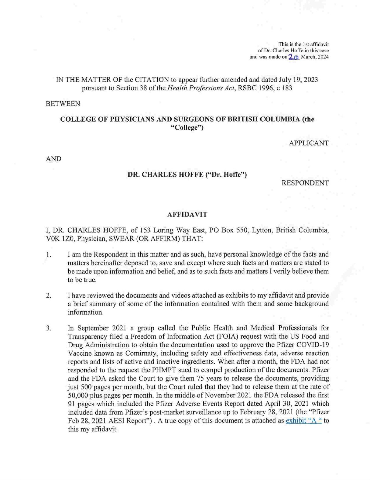
Piscataqua Region
Watershed
The Piscataqua Region Watershed is the land area
from which water drains to the Great Bay Estuary and
the Hampton-Seabrook Estuary. The watershed covers
1,086 square miles in New Hampshire, Maine and
Massachusetts.
Watershed Map

SPINNEY CREEK
Spinney Creek is a subtidal creek located just north of
the I-95 Piscataqua River Bridge, with shoreline in both
Eliot and Kittery. The Route 103 causeway separates
Spinney Creek from the Piscataqua River near their
conuence.
The causeway includes a tidal oodgate. The gate
was rebuilt in 2023 by MaineDOT, and it is operated
by the Town. The Town manages the gate to maximize
recreational activities on weekends and holidays and
manage aggressive widgeon grass (Rupia maritima)
growth.2
STURGEON CREEK
Sturgeon Creek runs from the conuence of Little Brook
and Great Creek to the Piscataqua River. It ows past
various land uses: industrial, institutional (Marshwood
Middle School), conserved wetlands, agricultural, and
rural residential before widening out at its meeting
with the Piscataqua. Its tidal portion extends from the
Piscataqua to Route 236. MaineDOT is beginning the
preliminary engineering for a project to replace the stone
arch culvert conveying the creek under Route 236.3
Sturgeon Creek and its watershed are described in more
detail in Water Resources.
SHOREY’S BROOK
Shorey’s Brook ows from Great Hill, between Goodwin
Rd. and Brixham Rd., to the Salmon Falls River. Its
last ¾-mile is the Eliot-South Berwick line, and its tidal
inuence extends about ¼-mile in from the river.
Shorey’s Brook and its watershed are described in more
detail in Water Resources.
Marine Water Quality Monitoring
Water quality, sh, salt marsh, and other monitoring
in the watershed is documented by the Piscataqua
Region Estuaries Partnership (PREP). Monitoring
sites documented by PREP that are close to Eliot’s
shoreline include:
>Water quality monitoring station in the Piscataqua
River at the Sturgeon Creek conuence (Upper
Piscataqua River station)
>Fish monitoring stations in the Piscataqua River
approximately in line with Houde Rd. and Pleasant
St. and at Dover Point
>Mussel tissue toxic pollution monitoring
station at Dover Point
TOXIC CONTAMINANTS IN MUSSEL TISSUE
The PREP State of Our Estuaries 2023 Report (“PREP
Report”) includes data on these contaminants collected
primarily between 1993 and 2016. Contaminant
concentrations were found to be generally decreasing
or staying the same; none were found to be increasing
(Table 11.1). Contaminants are grouped as either
inorganic, such as heavy metals, or organic, such as
polychlorinated biphenyls (PCBs).
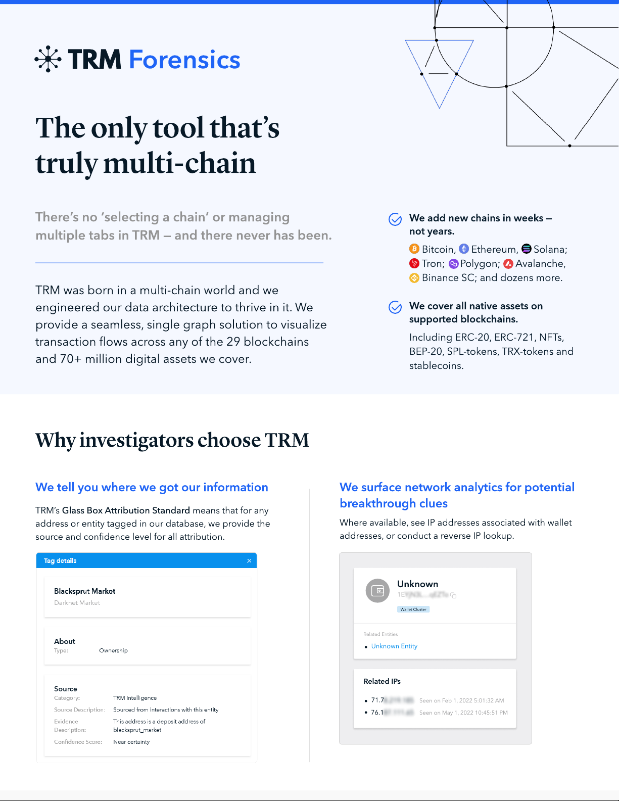
At Dover Point, concentrations of seven heavy
metals were found to be decreasing between 1993
and 2014, while PCBs showed no signicant trend
(Figure 11.2). Additional data collected in 2015-16
did not nd any upward trend, but suggested that the
concentration of one other heavy metal (mercury) may
also be decreasing. Referring to Dover Point, the report
concluded that “none of the recent data have exceeded
US Food and Drug Administration ‘tolerance’ or ‘action’
levels for mercury or PCBs in shellsh and seafood”.
Town of Eliot: 2025 Comprehensive Plan Marine Resources || 197
Photo from New Hampshire Sea Grant
“Toxic and persistent contaminants, such as PCBs,
mercury, and contaminants of emerging concern, can
accumulate in the tissue of filter-feeding bivalves
(e.g., mussels, clams, and oysters) and other marine
organisms, posing health risks to people and non-
human organisms when consumed”
– PREP State of Our Estuaries 20234

Town of Eliot: 2025 Comprehensive Plan Marine Resources || 198
TABLE 11.1 MARINE RESOURCES
FIGURE 11.2 MARINE RESOURCES
TOXIC CONTAMINANTS IN SHELLFISH AND SEAFOOD
Parameter Period Trend at 2014 Change with 2015-16 Data
Aluminum 1994-2014 No signicant trend No change
Cadmium 1994-2014 Decreasing No change
Chromium 1994-2014 Decreasing Change to no trend
Copper 1994-2014 No signicant trend No change
Iron 1994-2014 Decreasing No change
Lead 1994-2014 Decreasing No change
Mercury 2003-2014 No signicant trend Change to decreasing
Nickel 1994-2014 Decreasing Change to no trend
Silver 2003-2014 Decreasing No change
Zinc 1994-2014 Decreasing No change
PAH-Total 1994-2014 No signicant trend No change
PCB-Total 1994-2014 No signicant trend No change
Excerpt from Table 21.1 in the PREP Report: Trends in contaminant concentrations in mussel tissue…1993-2016. The excerpt only
includes the NHDP (Dover Point) monitoring station.5
Figure 21.1 in the PREP Report: Average concentrations (parts per billion dry wt.) of PCBs in blue mussel samples
from Dover Point (NHDP) from 1994 to 20166
PCBs in blue mussel samples from Dover Point from 1994-2016
PCB (PPB per dry g)

Town of Eliot: 2025 Comprehensive Plan Marine Resources || 199
>Point source nitrogen loading has gone down
thanks to investments in wastewater treatment
upgrades by the watershed municipalities. From 2012
to 2020, wastewater treatment facilities’ point source
nitrogen loading dropped 64%
>In 2020, the nitrogen load (627 tons) was the
lowest on record
>Precipitation and nonpoint source nitrogen loading are
correlated. Abnormally dry conditions between 2016 and
2020 likely inuenced lower nonpoint source loading,
suggesting that nonpoint source and total loading could
go back up in wetter years, other things equal
>The estuary has seen a drop in average dissolved
inorganic nitrogen – one of the three components of
total nitrogen load – a positive sign because it could be
inhibiting the excessive growth of nuisance seaweeds
>Despite trends in the right direction, the report
concludes that “nitrogen loading remains higher than the
amount recommended by the EPA [U.S. Environmental
Protection Agency] in the Great Bay Total Nitrogen
General Permit, issued in 2021. To meet that long-term
goal, nitrogen loading would have to be further reduced
by approximately 39% from the 2020 level”
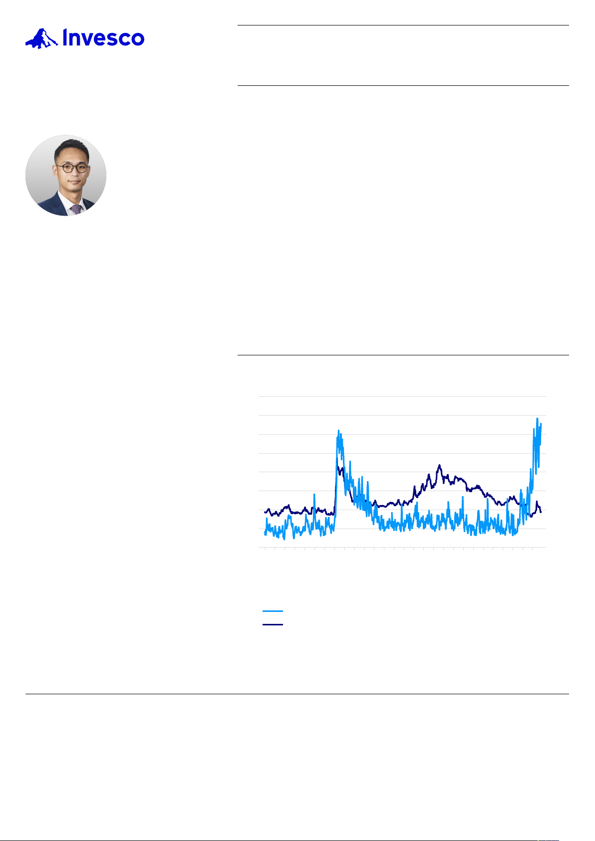
Focusing on Eliot’s part of the watershed, the report
found that the Upper Piscataqua River station showed
an apparent signicant decrease in inorganic nitrogen
concentrations (Figure 11.3).
NITROGEN LOADING
“Nitrogen ‘loading’ involves measurement of the rate at
which nitrogen is being added to estuarine water from
various sources, such as the land and atmospheric
deposition…Nitrogen loading levels that are too high
can cause problems in an estuary such as excessive
growth of phytoplankton, epiphytes, and nuisance
seaweeds. When these organisms die, bacteria and
other decomposers use the available dissolved oxygen
to break down the dead organic matter, decreasing
oxygen availability for other organisms, including sh and
shellsh. In addition, excessive phytoplankton, epiphytes,
and seaweed growth can have negative impacts on
sediment quality, water clarity, eelgrass, and benthic
invertebrates.”- PREP State of our Estuaries 20237
The PREP Report tracks the two types of nitrogen
loading: point source, such as wastewater treatment
facilities, and nonpoint source, such as stormwater runoff
and septic systems. The report showed mixed results:
>Average total nitrogen load in the Great Bay Estuary
stayed about the same in 2017-20 relative to 2012-16
– around 900 tons per year
>Estuary nitrogen load levels are generally lower than
they were in the mid- to late 2000s, when our
last Comprehensive Plan was developed
>Nonpoint sources contributed to 78% of the 2017-
20 nitrogen load
FIGURE 11.3 MARINE RESOURCES
Figure 8.3 in the PREP Report: Dissolved inorganic nitrogen (DIN) at
the Upper Piscataqua Station indicates a downward trend based on
data collected monthly at low tide between 2007 and 20218
Low Tide DIN (mg-N\L)
“In 2020, the nitrogen load (627 tons) was the lowest on
record.” – PREP State of Our Estuaries 2023
Photo of phytoplankton. Source: NOAA

Town of Eliot: 2025 Comprehensive Plan Marine Resources || 200
DISSOLVED OXYGEN
The PREP Report sets a dissolved oxygen threshold
of 5 mg/L. When it drops below this level, there
are negative impacts for aquatic life. The report
documents no signicant trends in dissolved oxygen
levels in the Great Bay Estuary.
While dissolved oxygen levels mostly “remain well
above 5 mg/L in the bays and open waters located at
the center of the Great Bay and in Portsmouth Harbor”,
there are mixed results for the Upper Piscataqua River
station. The report notes that “low dissolved oxygen
events do occur in the Upper Piscataqua River” among
other locations, but also that “both the Great Bay and
the Upper Piscataqua River Stations remain consistently
above the 5 mg/L threshold”.
TOTAL SUSPENDED SOLIDS
“Total suspended solids are particles suspended
in the water column measured as the dry weight
of particles ltered from a known volume of water.
They can consist of phytoplankton or pieces of plant
matter, but most total suspended solids are generally
made up of inorganic particles, such as sediment.
Sources of suspended solids include erosion from
streambanks, salt marshes, and the upland portion
of the watershed. Surface water inows, stormwater
runoff, and wastewater treatment euent all can
deliver total suspended solids to estuaries. In addition
to external sources of suspended solids, they can
also originate from resuspension within an estuary.
Increasing suspended sediments reduces water
clarity and light availability for primary producers
such as eelgrass, seaweeds, and phytoplankton. High
total suspended solid values can also negatively
impact oyster feeding and the aesthetic value of our
estuaries.” - PREP State of our Estuaries 202311
The PREP report finds that total suspended solid
(TSS) concentrations are generally higher now than
they were in 1989, but “appear to be decreasing in
recent years”. The Upper Piscataqua River station has
seen no significant change in TSS from 2007 to 2021,
with the range of median values at this station being
generally lower than all other stations except the
Lamprey River.12
Riverbank erosion has been identied as an issue along
various parts of the Piscataqua River in Eliot, such as
around the Boat Basin. Future erosion could put upward
pressure on TSS concentrations.
In summary, there are positive trends in the
Piscataqua Region for reduced nitrogen loads. That
is tentative good news for fish, shellfish, benthic
invertebrates, eelgrass, and water clarity. However,
wetter years could lead to increased loading through
added nonpoint source pollution from stormwater
runoff.
As a PREP municipality, Eliot can play a role in
reducing nitrogen loading. Through our shared
sewer system and Intermunicipal Agreement (IMA)
with the Town of Kittery, we have an avenue for
discussing point source nitrogen loading issues (if
any) with the Kittery wastewater treatment plant. For
nonpoint source nitrogen loading, septic systems
and stormwater management are key topic areas.
PREP’s Municipal Guide, discussed below, has
recommendations for each of these.
For more on stormwater management, see
Water Resources.
Photo from New Hampshire Sea Grant
“Fish and many other organisms need dissolved oxygen in the
water to survive. Dissolved oxygen levels can decrease due to
various factors, including rapid changes in wind, temperature,
and salinity, as well as prolonged periods of dense cloud cover.
Dissolved oxygen levels can also decrease because of nutrient
inputs. When nutrient loading is too high, phytoplankton and
seaweed can bloom and then die, after which bacteria and
other decomposers use oxygen to break down the dead organic
matter.” – PREP State of Our Estuaries 20239

Town of Eliot: 2025 Comprehensive Plan Marine Resources || 201
decline. Nutrients, such as nitrogen, spur the growth
of seaweed, epiphytes (algae growing on eelgrass
leaves), and phytoplankton, which then outcompete
eelgrass for light. Suspended sediments, too, block
light from eelgrass, which needs much more light than
most algal competitors...Eelgrass is also sensitive to
warming waters, a phenomenon that is occurring all
along the US East Coast.”
BACTERIA
“Activities such as shellsh harvesting and swimming
depend on safe water quality, which is tracked by
measuring concentrations of bacterial indicators of
fecal contamination. These water quality indicators
are affected by point and non-point pollution,
human (sewage) and non-human (animal) sources
of pollution, environmental conditions, and climate
change. Tracking these indicator organisms allows for
evaluation of water quality relative to potential risks for
human illness”.- PREP State of our Estuaries 202313
Measurements of fecal indicator bacteria have dropped
in the Great Bay Estuary, leading the PREP Report to list
it as one of six positive trends. (However, long-term data
tracking only occurs at two sites within the Great Bay,
so Upper Piscataqua River data is not reported.) The
report attributes this positive trend, in part, to “improved
stormwater infrastructure and wastewater treatment at
all facilities in the watershed”.14
The report notes: “Septic systems constructed too
close to waterbodies, poorly maintained, or failing can
also introduce harmful bacteria into local waterbodies
and contribute to nutrient loading”.15 Accordingly,
PREP recommends establishing a 100 ft. septic
system setback from water bodies, in addition to
recommendations on proper septic system inspection,
pumping, maintenance, upgrade, and replacement.
(See the Municipal Guide discussion below.)
EELGRASS
PREP tracks the acreage of eelgrass meadows and its
biomass (the weight of plant material per area), both
indicators of eelgrass health.17
>The total Great Bay Estuary acreage has not
changed notably in recent years (2017 vs. 2021)
but is 43% below the 1996 peak of 2,900 acres.
>Total biomass of eelgrass has also increased
since 2014 but is still much lower than the peak
period in the late 1980s and early 1990s
>Some parts of Great Bay have lost eelgrass
while other parts have gained
PREP notes that many factors affect eelgrass health:
“Eelgrass is a plant sensitive to several stressors
including wasting disease, temperature, habitat
disturbance, and predation. Most commonly, excessive
nutrients and sediments contribute to eelgrass
Photo from New Hampshire Sea Grant
“Eelgrass (Zostera marina) leaves slow the flow of water,
encouraging suspended materials to settle, thereby promoting
water clarity. Eelgrass roots stabilize sediments and both
the roots and leaves take up nutrients from sediments and
the water while providing habitat for fish, shellfish, and other
small invertebrates, which in turn support other wildlife such
as wading birds. Finally, eelgrass is sensitive to pollution —
especially nutrients and sediments — and often indicates the
status of an estuary’s water quality.”
– PREP State of Our Estuaries 202316

Town of Eliot: 2025 Comprehensive Plan Marine Resources || 202
FIGURE 11.4 MARINE RESOURCES
Figure 11.1 in the PREP Report: Seagrass distribution in the Great Bay Estuary in 2021, with biomass values for two sites.
Black outlined polygons show the extent of eelgrass in 1996.18
TABLE 11.3 MARINE RESOURCES
THE PREP GUIDE FOR MUNICIPAL LEADERS AND DECISION-MAKERS: FIVE ACTION TABLE
BUFFERS &
SETBACKS LAND
CONSERVATION SEPTIC
SYSTEMS STORMWATER
MANAGEMENT CLIMATE
RESILIENCE
Buffers are naturally
vegetated strips of land
directly upslope of a
water resource, such
as a lake, stream, river,
pond, estuary, or other
wetland type.
Permanent land
conservation is a
critical tool used to
protect water resources
and wildlife habitat.
An estimated 50% of
the population in the
Piscataqua Region
Watershed is served by
onsite septic systems.
Stormwater runoff
is a signicant source
of non-point source
pollution that
contributes to poor
water quality.
Climate change poses
an immediate and
increasing risk to all
aspects of life including
public health and safety,
natural resources,
infrastructure, and more.
The ve Action Table categories of recommendations from the PREP Guide for Municipal Leaders and Decision-Makers (2023). The full set of
recommendations can be found in the guide, which is linked to in the endnotes.

Town of Eliot: 2025 Comprehensive Plan Marine Resources || 203
Plans to Identify and Eliminate
Water Pollution Sources
At least two plans guide our efforts to identify and
eliminate pollution sources for both freshwater and
saltwater resources. The Stormwater Management
Plan (discussed further in Water Resources), is required
under our General Permit for Municipal Separate Storm
Sewer Systems (MS4 Permit). It is a local plan, but it
is developed through the Southern Maine Stormwater
Working Group (SMSWG), of which Eliot is a member,
and the recommended actions are similar across all
SMSWG community stormwater plans.
The PREP Guide for Municipal Leaders and Decision-
Makers (“Municipal Guide”)19 is another regional
resource. Designed as “a complementary piece to the full
2023 State of Our Estuaries report”, the Municipal Guide
provides recommendations for actions and informed
decision-making to support the health of our estuaries,
rivers, lakes, wetlands, and natural resources across the
Piscataqua Region Watershed” (Table 11.3).
Water Dependent Uses in Eliot
SHELLFISHING
Spinney Creek Shellsh, a local company, operates
a clam and oyster farm and shellsh processing
57
%
RESPONDED THAT
AQUACULTURE
(growing harvestable plants/animals in water)
IS A DESIRABLE TYPE
OF COMMERCIAL
DEVELOPMENT
COMMUNITY SURVEY FEEDBACK
Photo from Spinney Creek Shellsh in Eliot.
business in Spinney Creek, selling their products to
local restaurants and at festivals. Further inland,
Atlantic Aqua Farms (formerly J.P.’s Shellsh)
operates a distribution facility on Route 236.
There is commercial shing and shellshing (such
as lobstering, clamming, and oystering) from the
Kittery border up into the Salmon Falls River, with the
concentration in Eliot’s Lower Piscataqua. As of 2023,
Eliot had 34 lobster/crab harvester licenses, about half
of which were commercial licenses (Figure 11.5).20 Most
lobsters are ooaded to private or cooperative docks
and, occasionally, at the Boat Basin.
WATER QUALITY FOR SHELLFISHING
According to MaineDEP’s latest Integrated Water
Quality and Monitoring Assessment Report (2024
Draft), the Piscataqua River is a Category 2 marine
waterbody, which means it has attained a shellsh
harvesting designated use, except part of it is Category
3 – Estuarine and Marine Waters with Insucient Data
or Information to Determine if Shellsh Harvesting
Designated Use is Attained.
Previous reports listed impairment designations and
Total Maximum Daily Loads (TMDLs, referring to the
maximum amount of pollutant that may enter a water
body to meet water quality standards) along different
segments of the river, such as:
>Category 4-A: Estuarine and Marine Waters with
Impaired Non-Shellsh Harvesting Designated Uses
– TMDL Completed (Dissolved Oxygen); TMDL was
approved in 1999
>Category 5-A: Estuarine and Marine Waters
Impaired by Pollutants Other Than Those Listed
in 5-B Through 5-D – TMDL Required (Nutrient/
Eutrophication, Biological Indicators)21
Spinney Creek is Category 5-B-1: Estuarine and Marine
Waters Impaired for Shellsh Harvesting Designated
Use by Bacteria Only – TMDL Required (fecal coliform).
For this category, shellsh harvesting is restricted,
needing a special permit from Maine DMR or needing
to be done within growing areas.22 Shellsh harvested
from the designated growing area in the creek must be
depurated before being sold to the public. Spinney Creek
Shellsh operates a depuration plant near the shore.23
Spinney Creek is not individually listed in 2006-2016
MaineDEP Integrated Water Quality and Monitoring
Assessment Reports. It rst appears under Category
5-B-1 in the 2018/2020/2022 Report.24

Town of Eliot: 2025 Comprehensive Plan Marine Resources || 204
COMMERCIAL FISHING
As of 2023, Eliot had ve licensed Commercial Fishing
Crews, three licensed Commercial Fishing Singles, and
one licensed Commercial Pelagic and Anadromous
Crew (Figure 11.5).25
In 2023, commercial shing landings in York
County brought in about 7 million lbs. of sh,
shellsh, and seaweed, valued at about $25 million.
That ranks York sixth of Maine’s eight coastal
counties in weight and value. By comparison,
the highest-ranking county for weight, Knox,
brought in over 45 million lbs., and the highest-
ranking county for value, Hancock, brought in
about $160 million.26
Maine’s commercial shing industry will continue
to face challenges in the years ahead, such as
shifting sh and shellsh species distribution,
threats from invasive species, and climate change.
RECREATIONAL FISHING
As of 2023, Eliot had 33 registrants in the Recreational
Saltwater Registry and nine licensed Recreational
Saltwater Fishing Operators (Figure 11.5).28 Maine DMR
recommends the Boat Basin as an access point for
recreational saltwater shing, noting that it is “easily the
busiest boat ramp on the Piscataqua River”.29
RECREATIONAL BOATING AND BOAT REPAIR
Recreational boats dock at private residential
piers and the Great Cove Boat Club. Safe Harbor
Marina (formerly Kittery Point Yacht Yard) provides
boat repair and storage services. Another business
on site makes canvas boat covers and boat
accessories, as well as other canvas products.
SHIPPING
Eliot has no port or docking facilities, but shipping
occurs in the federally-maintained 35-foot channel
located in Eliot’s lower third of the Piscataqua River.
FIGURE 11.5 MARINE RESOURCES
0 5 10 15 20 25 30 35
Aquaculture (AL)
Commercial Fis hing Crew (CFC)
Commercial Fis hing Single (CFS)
Commercial Pelagic and Anadromous Crew (CPC)
Commercial Pelagic and Anadromous Single (CPS)
Commercial Shellfish (CS)
Lobster/Crab Class 1 (LC1)
Lobster/Crab Class 2 (LC2)
Lobster/Crab Class 2 +70 (LC2O)
Lobster/Crab Class 3 (LC3)
Lobster/Crab Class 3 +70 (LC3O)
Lobster/Crab Non Commercial (LNC)
Lobster/Crab student (LCS)
Menhaden Non Commercial (MENR)
Recreational Saltwater Fishing Operator (SWRO)
Recreational Saltwater Registry (SWR)
Vibrio Harvester (VH)
“Climate warming is expected
to facilitate the spread of
more invasive species in the
Northeast, and Maine’s streams,
river shores, and floodplains
are particularly vulnerable.
Intense flooding and increased
temperatures will impact fish
species such as brook trout
and Atlantic salmon.”
– Maine Won’t Wait (2024)27
The Piscataqua River Bridge as viewed from Great Cove Boat Club.
Photo by Brookelyn Gingras, SMPDC
Recreational shing on the Piscataqua River
Harvester licenses in Eliot by type, 2023. Source: MaineDMR

Town of Eliot: 2025 Comprehensive Plan Marine Resources || 205
Land Use Regulations
Affecting the Shoreline
The Town maintains a shoreland zoning ordinance (Town
Code Ch. 44) regulating land uses and establishing
building setbacks near the shoreline. The setback for new
buildings is generally 75 ft. from the normal high-water
line of rivers, streams, and regulated wetlands. Resource
Protection and Limited Residential shoreland zones line
most of the Piscataqua River and Spinney Creek, with
only a few parcels in the General Development zone.
Many riverfront residences have piers. New or
expanded pier systems are reviewed by the
Planning Board for consistency with shoreland
zoning standards.
Other regulations that help protect marine
resources, such as stormwater and oodplain
ordinance provisions, are discussed in
Water Resources.
TABLE 11.4 MARINE RESOURCES
ACCESS POINTS AND FACILITIES ALONG THE SHORE
Facility Location Access Use and Capacity Physical Condition Improvement Plans
Eliot Boat Basin 63 Junkins Ln. Public Paved boat ramp and
oat allowing smaller
and larger boats access
to the river
Satisfactory; adequate
public parking Recommendations in
Recreation and Open
Space to improve
amenities, shoreline
stability, and stormwater
management
Pleasant Street
Boat Ramp Pleasant St near
Riverside Ave. Public Paved boat ramp
allowing smaller boats
access to the river
Satisfactory; no public
parking available None
Great Cove Boat
Club 225 Main St. Private Marina with docks for
members, winter storage,
amenities
Satisfactory None known
Safe Harbor
Marina 857 Main St. Private Marina with boat
maintenance and storage Site, buildings, and
boat ramp approved
for upgrades
Upgrades approved by
Planning Board as part of
case PB23-2
Long Reach
Landing Marina 213 Pleasant St. Private Marina Bait shop recently
rebuilt Bait shop rebuilt after
Planning Board approval
in case PB21-21
Greenbriar
Estates Stacy Ln. Private Private boat ramp
owned by Greenbriar
Homeowners
Association
Unknown Unknown
Riverview
Subdivision Crescent Ln. Private Private water access and
dock owned by Riverview
Homeowners Association
Unknown Unknown
This plan does not recommend any new major access points to the Piscataqua River or Spinney Creek. However, discussion of a possible
small Spinney Creek public access point is in Recreation and Open Space.

Town of Eliot: 2025 Comprehensive Plan Marine Resources || 206
Harbor and Bay Management Plans
Portsmouth Harbor, comprising the last 8.8 miles of
the Piscataqua River, is managed by the US Army Corps
of Engineers. The Corps has managed the harbor and
conducted navigation improvement projects, such as
channel widening, since the 1880s.30
HARBOR ORDINANCE, HARBORMASTER,
AND HARBOR COMMISSION
Eliot has a Harbor Ordinance, codied in Chapter 30 of
the Town Code. The ordinance governs how moorings
are issued, renewed, used, and reassigned. It includes
provisions for allowed and restricted activities and for
protection of the marine environment.
The Town maintains a Harbormaster position that
manages and enforces the Harbor Ordinance, including
reviewing and issuing mooring permits. As of this writing,
the position is housed within the Eliot Police Department.
BRINGING BACK THE HARBOR COMMISSION
Eliot used to have a Harbor Commission, but it
was dissolved several years ago. A reinstated
Harbor Commission could advise the Harbormaster
and Town on harbor management; play a role
in reviewing waiver requests, appeals, and
complaints related to the Harbor Ordinance
(Sections 30-13 to 30-16); and be a forum for
discussing marine topics within the Town’s
purview, such as good environmental stewardship
of the river and tidal waters and ways to support
local marine businesses.
ACCESS POINTS AND FACILITIES ALONG THE SHORE
This plan does not recommend any new major access
points to the Piscataqua River or Spinney Creek.
However, discussion of a possible small Spinney Creek
public access point is in Recreation and Open Space.
TABLE 11.5 MARINE RESOURCES
SCENIC RESOURCES ALONG THE SHORELINE
Scenic resource Ownership Protections
All of River Road Road is Town-owned; abutting
properties are privately owned, except
for William Murray Rowe Park
Shoreland zoning, one conservation
easement on the south side of the road
Route 103
From the causeway
to Sturgeon Creek
Road is State-owned; abutting
properties are mostly privately owned;
Boat Basin is publicly owned
Shoreland zoning
Spinney Creek
Eliot and Kittery Shoreline parcels are mostly privately
owned; some small shoreland parcels
are Town-owned
Shoreland zoning
Shorey’s Brook
at the Salmon Falls River
Border of Eliot and South Berwick
Great Works Regional Land Trust
(Savage Preserve); some private
residential parcels
Permanent conservation via land trust,
shoreland zoning
Expanding upon the scenic resources listed in the 2009 Plan, p. 130

Town of Eliot: 2025 Comprehensive Plan Marine Resources || 207
Preserving a Working Waterfront and
Supporting Marine Businesses
While most of our shoreline is residential, preserving
existing working waterfront uses and marine businesses
is important to our local economy. Water-dependent
businesses and economic activity have been part of our
economy for centuries. Past and present, they include:
>Boatbuilding
>Boat maintenance
>Marinas
>Recreational boating
>Boat storage and hauling
>Commercial shing and shellshing
>Aquaculture
>Seafood warehousing and wholesaling
>Production of canvas boat covers and accessories
Since Eliot, like the Seacoast region, has a very
strong housing market, these working waterfront
uses are susceptible to residential development
pressures. Preserving these waterfront properties
requires a sustained commitment from their owners
to keep them as working waterfronts, such as the
recent effort by Safe Harbor Marinas to upgrade the
former Kittery Point Yacht Yard.
Safe Harbor Marinas (formerly Kittery Point Yacht Yard) boat maintenance
facility. SHM was approved by the Eliot Planning Board in 2023 to upgrade
the boatyard. Photo by Brookelyn Gingras, SMPDC
The goals, policies, and strategies outline how we can preserve
and support our working waterfront and marine industry.

Town of Eliot: 2025 Comprehensive Plan Marine Resources || 208
MARINE RESOURCES GOALS, POLICIES & STRATEGIES
Goal, Policy,
or Strategy
Description Responsibility or
Partnership
Implementation
Timing
Goal 1 Healthy marine life and clean water quality in the Piscataqua River and its tributaries
Policy 1 Protect, maintain and, where warranted, improve marine habitat and water quality
Strategy 1 Encourage owners of marine businesses and industries to participate in
clean marina/boatyard programs Conservation Commission,
Planning Oce
Ongoing
Strategy 2 Support implementation of local and regional harbor and bay management
plans, including, but not necessarily limited to, recommendations of the
Piscataqua Region Estuaries Partnership (PREP)
Planning Oce, Planning
Board, Conservation
Commission, Southern Maine
Stormwater Working Group
Ongoing
Strategy 3 Develop a watershed-based management plan for Spinney Creek to improve
water quality and reduce nonpoint source pollution, and implement its
recommendations
Conservation Commission,
Planning Oce, Public Works,
consultant, Southern Maine
Stormwater Working Group,
Town of Kittery
Mid (plan)
Strategy 4 In conjunction with Natural Resources Goal 1, Policy 2; the Open Space
Plan; and the New Hampshire Coastal Watershed Conservation Plan, work
with conservation partners to permanently conserve land that provides
benets and key functions for the coastal and marine environment (e.g.,
salt marshes and wetlands for storm surge buffering, ood storage,
pollutant removal, drinking water protection, etc.)
Conservation Commission,
Town Manager, Planning Oce,
Select Board, land trusts,
nonprots, governmental
resource agencies, willing
landowners
Ongoing
Cross-
reference Water Resources Goals 1 and 2 (Better water quality for surface waters
and groundwater), including Goal 2, Policy 2 (Reduce the risk of pollution
discharges via septic systems)
Goal 2 Healthy marine life and clean water quality in the Piscataqua River and its tributaries
Policy 1 Protect, maintain, and foster water-dependent land uses and balance them with other complementary land uses
Strategy 1 Provide information about the Working Waterfront Access Pilot Program
and current use taxation program to owners of waterfront land used to
provide access to or support the conduct of commercial shing activities
Planning Oce, Town
Assessor Ongoing
Strategy 2 Support the ability for small-scale marine and water-dependent businesses,
whose scale and character are reasonable within their context, to establish
themselves and thrive in the community. Clarify zoning and land use
regulations for water-dependent home businesses
Planning Oce, Planning
Board, Town Manager, Select
Board
Ongoing
Policy 2 Protect, maintain, and enhance public access to the shore for both commercial and recreational uses
Strategy 1 Identify needs for additional recreational and commercial access (which
includes parking, boat launches, docking space, sh piers, and swimming
access), for example, Spinney Creek access from Main Street for small craft
Town Manager, Recreation
Department, Planning Oce,
Conservation Commission,
Select Board
Mid
Strategy 2 Provide sucient funding for and stang of the Harbormaster, and
consider reinstituting the Harbor Commission Town Manager, Finance
Director, Select Board Ongoing
Strategy 3 Work with local property owners, land trusts, and others to protect major
points of physical and visual access to coastal waters, especially along
public ways and in public parks
Town Manager, Recreation
Department, Planning Oce,
Public Works, Conservation
Commission, Planning Board,
Select Board
Ongoing
1
GOAL
2
GOAL

Town of Eliot: 2025 Comprehensive Plan Marine Resources || 209
MARINE RESOURCES GOALS, POLICIES & STRATEGIES
Goal, Policy,
or Strategy
Description Responsibility or
Partnership
Implementation
Timing
Goal 3 A shoreline and marine environment that is resilient to climate change
Policy 1 Help Eliot’s shoreline and the Piscataqua River become more resilient to sea level rise and
other likely climate change impacts
Strategy 1 Address the ndings and implement the recommendations of the
Climate Change Vulnerability and Resilience Assessment that relate
to marine resources
Town Manager, Planning Oce,
Planning Board, Conservation
Commission, Select Board,
SMPDC
Depends on
recommendation
Strategy 2 Adopt a sea level rise (SLR) scenario to be used in development review,
land use planning, and capital improvement projects Conservation Commission,
Planning Board, Planning
Oce, SMPDC
Short
3
GOAL

1 Wells Reserve at Laudholm. wellsreserve.org/conservation/in-your-community/rivers-and-streams/piscataqua-river
2 Town of Eliot. Proposed Spinney Creek Tide Gate Schedule.
www.eliotmaine.org/DocumentCenter/View/1007/2024-Tide-Gate-Schedule---Spinney-Creek-PDF?bidId=
3 MaineDOT. Work Plan for Calendar Years 2024-2026. www.maine.gov/mdot/projects/workplan/
4 Piscataqua Region Estuaries Partnership (PREP) State of our Estuaries 2023.
www.stateofourestuaries.org/wp-content/uploads/2023/05/SOOE-2023-Digital.pdf
5 PREP State of our Estuaries 2023
6 PREP State of our Estuaries 2023
7 PREP State of our Estuaries 2023
8 PREP State of our Estuaries 2023. The Figure 8.3 caption in the PREP report is abridged in the body text. It continues: “…and
shown here as box and whisker plots. Boxes encompass the middle 50% of the data points. The horizontal line in each box is
the median and the vertical whiskers encompass the remaining data. ‘Outliers’ are shown as individual points. Some years are
omitted due to missing data. Blue line represents signicant linear regression through annual median values. Data source: Great
Bay National Estuarine Research Reserve and the Jackson Estuarine Laboratory, UNH”
9 PREP State of our Estuaries 2023
10 PREP State of our Estuaries 2023
11 PREP State of our Estuaries 2023
12 PREP State of our Estuaries 2023
13 PREP State of our Estuaries 2023
14 PREP State of our Estuaries 2023
15 PREP State of our Estuaries 2023
16 PREP State of our Estuaries 2023
17 PREP State of our Estuaries 2023. See pp. 58-61 for the data cited and quotes in this section.
18 PREP State of our Estuaries 2023. The gure caption notes the following data source: Michael Routhier, Ray Grizzle and
Krystin Ward, UNH. 1996 data from Fred Short, UNH
19 Available at: www.stateofourestuaries.org/2023-reports
20 2020 Vessel and Licenses spreadsheet from DMR provided in the State Comprehensive Plan data package.
21 Reports available here: www.maine.gov/dep/water/monitoring/305b/index.html
22 MaineDEP. Integrated Water Quality Monitoring and Assessment Reports (2024 Draft Report).
www.maine.gov/dep/water/monitoring/305b/index.html
23 Maine DMR. Application for Change in Gear Authorization.
Spinney Creek, Eliot; Findings of Fact, Conclusions of Law, and Decision; June 14, 2022.
www.maine.gov/dmr/sites/maine.gov.dmr/les/inline-les/PISC%20SC_SpinneyCreekShellsh_DecisionHistory.pdf
24 Reports available here: www.maine.gov/dep/water/monitoring/305b/index.html. A word search was done to look for
“Spinney” in each report’s appendix.
25 2020 Vessel and Licenses spreadsheet
26 Maine DMR. 2023 Landings Information. www.maine.gov/dmr/sheries/commercial/landings-program/landings-data
27 Available at: www.maine.gov/climateplan/the-plan
28 2020 Vessel and Licenses spreadsheet
29 Maine DMR. Where to Fish Along Maine’s Coast. www.maine.gov/dmr/sheries/recreational/anglers-guide/where-to-sh
30 US Army Corps of Engineers. www.nae.usace.army.mil/Missions/Civil-Works/Navigation/New-Hampshire/Portsmouth/
Town of Eliot: 2025 Comprehensive Plan Marine Resources || 210
MARINE RESOURCES ENDNOTES